Archaeological Excavations at the Charlton House Site, Williamsburg, Virginia
Colonial Williamsburg Foundation Library Research Report Series - 1701
John D. Rockefeller, Jr. Library
Colonial Williamsburg Foundation
Williamsburg, Virginia
2004
Colonial Williamsburg Archaeological Reports
Archaeological Excavations at the Charlton House Site,
Williamsburg, Virginia
The Colonial Williamsburg Foundation
Department of Archaeological Research
P.O. Box 1776
Williamsburg, VA 23187-1776
Archaeological Excavations at the Charlton House Site, Williamsburg, Virginia
The Colonial Williamsburg Foundation
Department of Archaeological Research
P.O. Box 1776
Williamsburg, VA 23187-1776
Mark Kostro
Project Archaeologist
Marley R. Brown III
Principal Investigator
October 2004
Management Summary
Between January 14 and March 12, 2002, archaeologists from Colonial Williamsburg's Department of Archaeological Research (D.A.R.) carried out an archaeological investigation of the Charlton House (Block 9, Building 30), located on Colonial Lot 22 on the south side of Duke of Gloucester Street in Williamsburg, Virginia (Figure 1). The investigation was prompted by maintenance plans to waterproof the exterior of the building's foundation walls in an effort to alleviate moisture problems in the structure's basement. The waterproofing plans would require the removal of all soils abutting against the foundations in order to gain access to the walls, and thus would destroy any intact archaeological layers or features that may be intact around the Charlton House. Consequently, in an effort to salvage the archaeological information before its imminent destruction, archaeological trenches were excavated along the exterior of the Charlton House in each of the areas to be directly impacted by the impending waterproofing plans.
The 2002 archaeological excavations consisted of several hand dug trenches measuring approximately two-meters in width along the north, south and west elevations of the Charlton House. The excavations were conducted following natural stratigraphy until undisturbed subsoil was reached. Each feature was documented and excavated. All soils, with the exception of those from known restoration or post-restoration contexts, were screened through one-quarter-inch hardwire mesh in order to collect any artifacts contained within the soil. To the east of the Charlton House, the narrow alley between the house and the reconstructed King's Arms Barber Shop (Building 29B) was not excavated due to significant ground disturbance at that location which occurred during the reconstruction of the shop.
Ultimately, the results of the archaeological excavations revealed significant evidence
regarding the occupation of the house and property; and the evolution of the
surrounding landscape from the seventeenth through the late nineteenth-centuries.
Particularly remarkable was the high degree of preservation of seventeenth and eighteenth-
century features and soil layers between the north elevation of the Charlton
House and Duke of Gloucester Street. Highlighting some of the most significant discoveries
include the identification of an unusually large ditch feature that is believed to
have served as a seventeenth-century boundary marker, property line, or drainage
ditch prior to the formation of Williamsburg in 1699. The excavations also revealed a
line of very large postholes that likely supported the wall of a large post-in-ground
barn or warehouse that was likely erected during William Byrd II's ownership of the
lot in the first half of the eighteenth-century. Post-dating the barn/warehouse structure,
the northeast corner of a narrow brick foundation for a small structure dating to the
middle of the eighteenth century was also uncovered. Additional middle to late eighteenth-
century features included; a small intact portion of the Charlton House builder's
trench; the brick foundation and demolition debris from a late eighteenth-century
wigmaker/tailor's shop west of the Charlton House; and a the heavily disturbed fragments
of a brick paved sidewalk along Duke of Gloucester Street in front of the
 Figure 1. Charlton House (December 2001)
Charlton House. Finally, various occupation layers around the house were also identified
dating from the seventeenth through the twentieth centuries.
Figure 1. Charlton House (December 2001)
Charlton House. Finally, various occupation layers around the house were also identified
dating from the seventeenth through the twentieth centuries.
Overall, the results of the Charlton House excavations proved to be very exciting, and successfully exemplified how limited stratigraphic archaeological excavations can supply a great deal of valuable new information about the occupation and use of a particular property and the overall development of Williamsburg as well. The excavations have also demonstrated the potential for additional archaeological exploration of the property, particularly with regard to the area between the Charlton House and Duke of Gloucester Street.
Table of Contents
| Page | |
| Management Summary | i |
| List of Figures | v |
| List of Tables | vii |
| Acknowledgments | ix |
| Chapter 1. Historical Context and Development | 1 |
| Middle Plantation and Early Williamsburg (1632-1699) | 1 |
| James Shields (ca. 1699-1707) | 3 |
| William Byrd II (1707-1740) | 4 |
| James Crosby (1740-ca. 1750) | 4 |
| Alexander Archibald Buchanan and Company (1750-ca. 1759) | 6 |
| John Carter (ca. 1760-1769) | 6 |
| Anthony Geoghegan and Simon Brazier (1768) | 8 |
| Edward and Jane Charlton (ca. 1770-1784) | 9 |
| James Slate (1774-ca.1780) | 11 |
| The Charlton Heirs (1785-1795) | 13 |
| William Russell (1795-1812) and Catherine Russell (1812-1819) | 14 |
| The Henley and Servant Families (1819-1928) | 14 |
| Colonial Williamsburg Foundation (1929-present) | 19 |
| Chapter 2. Previous Archaeological and Architectural Investigations | 21 |
| 1929-1930 Architectural Investigations | 21 |
| 1933 Cross Trenching | 21 |
| 1966 Archaeological Excavations | 22 |
| 1999 Archaeological Excavations | 26 |
| Summary | 29 |
| Chapter 3.Research Design/Methods | 31 |
| Chapter 4. Research Results | 35 |
| Middle Plantation-Period Features | 35 |
| Shields, Byrd, and Crosby-Period Features | 38 |
| Alexander Archibald Buchanan and Company and John Carter-Period Features | 54 |
| Charlton House Features | 63 |
| Edward Charlton Wigmaker Shop/James Slate's Tailor Shop | 76 |
| Russell Family Features | 83 |
| Henley and Servant Family Features | 84 |
| Colonial Williamsburg Restoration Features | 91 |
| Chapter 5. Conclusions and Suggestions for Future Research | 93 |
| Suggestions for Further Research | 94 |
| Bibliography | 97 |
| iv | |
| Appendices | |
| Appendix A. Master Context List | 103 |
| Appendix B. Context Register | 105 |
| Appendix C. Artifact Inventory | 109 |
List of Figures
| Page | |
| Figure 1. Charlton House (December 2001) | ii |
| Figure 2. Location of the Charlton House | 2 |
| Figure 3. 1699 Theodore Bland survey of Williamsburg | 2 |
| Figure 4. Detail of 1782 Frenchman's Map | 12 |
| Figure 5. Detail map of 1965-1967 archaeological excavations | 12 |
| Figure 6. Copy of 1796 Mutual Assurance Society Map of Lot 22 | 15 |
| Figure 7. Copy of 1806 Mutual Assurance Society Map of Lot 22 | 15 |
| Figure 8. Copy of 1823 Mutual Assurance Society Map of Lot 22 | 17 |
| Figure 9. Circa 1928 photograph of the Charlton House, north elevation | 17 |
| Figure 10. Circa 1928 photograph of the Charlton House, south elevation | 18 |
| Figure 11. 1904 Sanborn fire insurance map of Lot 22 | 18 |
| Figure 12. Photograph of the reconstructed Charlton House (circa 1930s) | 19 |
| Figure 13. 1933 Cross-trenching plan map of Lot 23 | 22 |
| Figure 14. 1966 photo of Charlton House excavations | 23 |
| Figure 15. 1966 photo of Charlton House excavations | 24 |
| Figure 16. Plan of first-period building archaeological features | 24 |
| Figure 17. Plan of second-period building archaeological features | 26 |
| Figure 18. Profile drawing of the stratigraphy across the Second Period Building | 27 |
| Figure 19. Location of the archaeological trenches excavated in 1999 | 28 |
| Figure 20. Location of the archaeological trenches excavated in 2002 | 32 |
| Figure 21. Plan of the Middle Plantation boundary/drainage ditch feature | 36 |
| Figure 22. Known Middle Plantation-period archaeological features | 37 |
| Figure 23. Artifacts from the early eighteenth-century sheet refuse layers | 42 |
| Figure 24. Profile drawing of the Early Fence Line postholes (M3) | 43 |
| Figure 25. Plan of Early Post-In-Ground Structure postholes (M4) | 47 |
| Figure 26. Photograph of Early Post-In-Ground Structure postholes to the east of the front | 47 |
| Figure 27. Photograph of Early Post-In-Ground Structure postholes to the west of the front porch | 47 |
| Figure 28. Photograph of a posthole profile from the Early Post-In-Ground Structure | 50 |
| Figure 29. S. Cobbs wine bottle seal | 50 |
| Figure 30. Artifacts from the mid-eighteenth-century sheet refuse layer (M5) | 56 |
| Figure 31. Pipestems from mid-eighteenth-century sheet refuse layer (M5) | 57 |
| Figure 32. Harrington histogram | 58 |
| Figure 33. Plan of planting features | 58 |
| Figure 34. Plan of Early Brick Foundation | 62 |
| Figure 35. Photograph of northeast corner of the Early Brick Foundation | 62 |
| Figure 36. Comparison of artifacts from the Charlton House construction-related features and the sheet refuse layers | 65 |
| Figure 37. Photograph of the intact brick sidewalk to the east of the reconstructed front porch | 67 |
| vi | |
| Figure 38. Sheet refuse layers to the north of the Charlton House | 67 |
| Figure 39. Comparison of household refuse and construction-related artifacts from the Charlton occupation layers | 73 |
| Figure 40. Tobacco pipe stems from the Charlton occupation layers | 74 |
| Figure 41. Charlton/Slate shop foundations | 77 |
| Figure 42. Photograph of the east foundation wall of the Charlton/Slate shop | 78 |
| Figure 43. Tailor-related artifacts | 83 |
| Figure 44. Copy of 1796 Mutual Assurance Society map of Lot 22 | 84 |
| Figure 45. Crushed plaster layer within the interior of the Charlton/Slate shop | 85 |
| Figure 46. Copy of 1823 Mutual Assurance Society map of Lot 22 | 86 |
| Figure 47. Erosion gully to the south of the Charlton House | 88 |
| Figure 48. Post-1850 layers north of the Charlton House | 89 |
| Figure 49. Circa 1928 photograph of the south elevation of the Charlton House | 90 |
| Figure 50. Nineteenth-century brick piers south of the Charlton House | 91 |
| Figure 51. Twentieth-century pantry foundation | 92 |
List of Tables
| Page | |
| Table 1. Artifacts from Early Eighteenth-Century Sheet Refuse Contexts | 41 |
| Table 2. Early Post-In-Ground Structure Postholes | 49 |
| Table 3. Faunal Remains from 1707-1750 Period Contexts | 53 |
| Table 4. Artifacts from Mid-Eighteenth-Century Sheet Refuse Contexts | 55 |
| Table 5. Relative Frequencies of Faunal Remains from 1750-1769 Period Contexts | 60 |
| Table 6. Artifacts from Charlton House Construction-Related Contexts | 64 |
| Table 7. Artifacts from the Charlton-Period Contexts | 71 |
| Table 8. Relative Frequencies of Faunal Remains from 1770-1795 Period Contexts | 75 |
| Table 9. Artifacts from the Charlton/Slate Shop Occupation Contexts | 80 |
| Table 10. Relative Frequencies of Faunal Remains from Tailor Shop Occupation Contexts | 81 |
| Table 11. Artifacts from the Charlton/Slate Shop Demolition Contexts | 87 |
| Table 12. Relative Frequencies of Faunal Remains from Nineteenth-Century Contexts | 89 |
Acknowledgments
The successful completion of the Charlton House excavations was due to support and cooperation of a number of individuals. Marley R. Brown III, Director of Archaeological Research, provided general direction and support throughout the project. Staff Archaeologist Andrew C. Edwards directly supervised the project, offered his guidance and experience during the course of the excavations and the subsequent analysis, and offered valuable comments on this manuscript. Larry Heath, from Colonial Williamsburg's facilities maintenance, was a frequent visitor and interested supporter of the archaeological fieldwork. Interpretation of the evidence of the post-in-ground structure was greatly enhanced by the contributions of Architectural Historian Willie Graham, who lent his considerable expertise on Chesapeake earthfast architecture. Finally, the successful completion of the fieldwork would not have been possible without the hard work and skill of the field crew that included: Andrew Butts, Hank Lutton, Quintina Fields, Jason Boroughs, Lucie Vinciguerra, and Jameson Harwood. All the artifacts were processed and inventoried by laboratory technician Susan Christie. All faunal material was inventoried by zooarchaeological lab volunteer Lyell Smollen and Assistant Curator of Zooarchaeology Steve Atkins. The combined artistic skills of Carrie Alblinger and Heather Harvey produced the final report graphics, and Greg Brown formatted the final report.
xChapter 1.
Historical Context and Development
The Charlton House, which draws its name from its eighteenth-century owners and occupants Edward and Jane Charlton, is situated on Colonial Lot 22 within Block 9 of Colonial Williamsburg's Historic Area. The house and block are located on the south side of Duke of Gloucester Street within the limits of the City of Williamsburg (Figure 2). The house was purchased by the Colonial Williamsburg Restoration in 1929 and was among the first properties to be acquired in the effort to recreate Virginia's colonial capital. The house underwent an extensive restoration between 1929 and 1930, and has been maintained as a private residence ever since. Unfortunately for researchers of the property, however, few documents pertaining to the long history of the house and lot have survived, thus obscuring much of its history prior to the nineteenth century. As a result, archaeology exists as the primary means of inquiry into understanding the historical development of the property.
Middle Plantation and Early Williamsburg (1632-1699)
Preceding the formation of Williamsburg in 1699, the environs midway between the James and York Rivers that would come to encompass the eighteenth-century colonial capital were known as Middle Plantation. Established in 1632/3 by an Act of Assembly, Middle Plantation was formed as the first interior English settlement on Virginia's tidewater peninsula (Metz et al. 1998:22). Among Middle Plantation's residents in the second half of the seventeenth century was John Page, who owned several large tracts of land in the area, including several patents totaling 330 acres at Middle Plantation. Between the 1660s and 1680s Page gained considerable land holdings and wealth, during which time he constructed a brick manor house on his patent at the present-day site of the Bruton Heights School. As his wealth increased, so did Page's stature in the community, and he ultimately became one of the most prominent men in the colony (Metz et al. 1998:4).
At the same time, the community at Middle Plantation grew significantly in both size and political strength (Metz et al. 1998:85). The construction of Bruton Parish Church, along with the establishment of the College of William & Mary at Middle Plantation, signified the ever-increasing importance of the former inland outpost. John Page was an ardent supporter of both ventures, even providing land for the church and churchyard. By the turn of the century, Middle Plantation had eclipsed Jamestown as the colony's center, and in 1699 the capital was relocated from Jamestown to Middle Plantation. As part of the capital's relocation, a new 220-acre town, named Williamsburg, was planned at Middle Plantation between the heads of Archer's Hope (College) Creek and Queen's Creek, straddling the boundary line between James City County and York County (McCartney 1997:135-137).
As part of the plan for the development of Williamsburg, Theodore Bland completed
a survey of the town's boundaries (Figure 3). The new town plan was established
along a grid, bisected by a one-mile long street (Duke of Gloucester Street) that
2
 Figure 2. Location of the Charlton House.
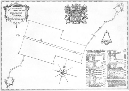 Figure 3. 1699 Theodore Bland survey of Williamsburg.
3
stretched east from the College of William & Mary to the new Capitol building, with
half-acre lots oriented to the new town grid fronting along Duke of Gloucester Street.
Land for the new town was acquired through purchases via the town's Trustees from
the various individuals whose property fell within the newly surveyed town limits. Among
the properties acquired included a portion of John Page's property, which at this point
was owned by Page's granddaughter, Elizabeth Page. John Page had died in 1692,
seven years before Williamsburg was established. Upon his death, he left his Middle
Plantation estate to his eldest son Francis. Francis, however, died within three months
of his father, and intern left the estate to his own daughter Elizabeth. Elizabeth died
only a few years later in 1702, at which point the property was inherited by her husband
(and first cousin), also named John Page (Metz et al.1998:87-88). The property
purchased from the Page family included present-day Duke of Gloucester Street,
Nicholson Street, and part of Francis Street, and would have included present-day
Block 9 (Metz et al.1998:31-34).
Figure 3. 1699 Theodore Bland survey of Williamsburg.
3
stretched east from the College of William & Mary to the new Capitol building, with
half-acre lots oriented to the new town grid fronting along Duke of Gloucester Street.
Land for the new town was acquired through purchases via the town's Trustees from
the various individuals whose property fell within the newly surveyed town limits. Among
the properties acquired included a portion of John Page's property, which at this point
was owned by Page's granddaughter, Elizabeth Page. John Page had died in 1692,
seven years before Williamsburg was established. Upon his death, he left his Middle
Plantation estate to his eldest son Francis. Francis, however, died within three months
of his father, and intern left the estate to his own daughter Elizabeth. Elizabeth died
only a few years later in 1702, at which point the property was inherited by her husband
(and first cousin), also named John Page (Metz et al.1998:87-88). The property
purchased from the Page family included present-day Duke of Gloucester Street,
Nicholson Street, and part of Francis Street, and would have included present-day
Block 9 (Metz et al.1998:31-34).
James Shields (ca. 1699-1707)
Bounded by Duke of Gloucester Street to the north, Francis Street to the south, Botetourt Street to the west, and the Capitol Square to the east, Block 9 was subdivided into eight half-acre lots (Colonial Lots 20-27) upon the establishment of the town. In June 1699, in an effort to enhance the town's appearance, and to encourage its growth, the Assembly passed, "An Act Directing the Building the Capitoll and the City of Williamsburg" which included various building requirements. Among the provisions set forth was a stipulation that purchasers along Duke of Gloucester Street had to build on each lot within twenty-four months of purchase, or the lot would revert back to the Trustees of the city. These requirements were modified in 1705 with regards to size and substance of buildings to be built, in addition to instituting provisions that encouraged the purchasing of multiple lots (Hellier 1989:12-14).
Indirect evidence suggests that prior to 1707 lots 22, 23, 24 and 25 were originally conveyed to James Shields, a local tailor and tavern keeper. Shields's ownership is indicated by several subsequent deeds transferring the properties to other owners. Soon after his purchase, Shields erected a dwelling house on lot 24, fronting on Duke of Gloucester Street. Shield's neighbor to the east was William Robertson, to whom lots 26 and 27 were conveyed in 1707 as well. Robertson constructed a dwelling in the southeastern corner of lot 26 fronting along Francis Street. To the west of Shields, the ownership of lots 20 and 21 in 1707 is not known, although they were eventually conveyed to Richard Bland at an unknown date prior to 1716. Bland had also acquired two lots on the north side of Duke of Gloucester Street (Block 17, Lots 53 and 54) that were conveyed to him from the trustees of the city in 1708. Bland lived at Jordan's Point in Charles City County, but was a frequent visitor to Williamsburg where he also had a townhouse, and a store that he managed for William Byrd II of Westover. The locations of his store and townhouse are unknown, but they may have been located on either of his lots on the northern or southern side of Duke of Gloucester Street (Brown 1986:1-2).
William Byrd II (1707-1740)
On May 12, 1707 James Shields conveyed Lot 24 to William Byrd II for £120 sterling, "with one good dwelling-house tereon built." There exists no record of a purchase by Byrd of Lots 22 and 23, but his ownership of these two additional lots is indicated by a later deed that describes the conveyance of three lots "which formerly belonged to the late Colonell William Bird" located on the south side of Duke of Gloucester Street opposite the Raleigh Tavern. Lots 22, 23, and 24 are situated most directly opposite the Raleigh Tavern. Although only the conveyance for Lot 24 is known, all three lots were likely purchased around the same time. Shields also owned Lot 25 to the east, which he sold to Jean Marot in January 1707/8, who operated a tavern on the lot. William Byrd II and Jean Marot were likely well acquainted previous to their circumstance as neighbors, as Marot had once served as secretary to William's father, William Byrd I (Brown et al. 1990:45).
Following William Byrd II's acquisition of Lots 22, 23, and 24 in 1707, there exists little evidence regarding their disposition and use. It is possible that Byrd may have rented one or more of the lots to Jean Pasteur, a native of Switzerland, who came to Virginia in 1700 and worked in Williamsburg as a wigmaker. In writing to Thomas Jones in July 1728, Byrd wrote, "I have sent You a note on my Tenant Pasteur for that Summ being £2.12.6…" (Jones Papers, Library of Congress cited in Stephenson 1956) . The correspondence clearly identifies Pasteur as Byrd's tenant, however, on which property Pasteur was renting from Byrd is not specified. It remains possible that he may have rented one or more of Byrd's lots on Duke of Gloucester Street.1
If Pasteur was renting from Byrd on Block 9, he most likely moved off the lot in 1728. In that year, Pasteur purchased from John White a small shop on a portion of lot 55 on the north side of Duke of Gloucester Street where he most likely operated his wig making business (Stephenson 1956). Other than the reference to Pasteur as Byrd's tenant, there exist no other known references to any of Byrd's three lots on Block 9.
James Crosby (1740-ca. 1750)
In the second quarter of the eighteenth century, Williamsburg increasingly became a commercial center. As the city grew, various merchants and craftsmen established a number of successful businesses at locations throughout the city. Certain enterprises were also known to cluster together within a particular part of the city to take advantage of, as well as, compete for specific clientele. By mid-century, one of the areas to experience the most substantial growth was the east end Duke of Gloucester Street, near the Capitol. This area would come to be known as "The Exchange," and was the location of several taverns and coffeehouses that provided food, drink, lodging and entertainment for the people coming to the capital on business. Complimenting the brisk tavern businesses within "The Exchange" were merchants and craftsmen, who were also seeking the attention of visitors to the capital. Wigmakers, barbers, tailors, and an assortment merchants, all sought to establish their businesses "in the most 5 public part of the city." Many of these individuals established their shops along the eastern end of Duke of Gloucester Street on what are known today as Blocks 9 and 17 (Reps 1972:179).2
The limited documentary evidence suggests that sometime in the 1740s, James Crosby, a merchant from Scotland, became the next owner of lots 22, 23, and 24. Unfortunately, however, there exists no known date of when Crosby first acquired the lots. It is unknown if Crosby purchased the lots from William Byrd II, who died in 1744, or if he purchased the lots from Byrd's heirs. One reference hints that Crosby may have been occupying the lots as early as 1740, as the Carter Burwell papers indicate that James Bray sold bricks and lumber to a "Mr. Crosby, mercht," in that year. A second reference to Crosby's ownership was found in an advertisement for Alexander Finnie's wigmaking shop in the Virginia Gazette in 1745:
Just imported in the Ship Restoration, Capt. John Wilcox, from London, by the Subscriber, next Door to Mr. Crosbie's, Merchant, in Williamsburg, A Choice Parcel of Hairs, and other Materials, for making Wigs, prepa'd by the best Hands in London…(Virginia Gazette, Parks, ed., July 4, 1745).Although four additional advertisements were placed in the Virginia Gazette regarding Finnie's wigmaking shop between September 1745 and September 1746, none provide any additional details regarding the location of the shop, or the identity of Finnie's neighbors.
The first clear association between Crosby and Lots 22, 23, and 24 is not documented until 1750, when Crosby was identified as the owner of three city lots located opposite the Raleigh Tavern that were sold to Alexander Archibald Buchanan and Company:
In addition to establishing Crosby as the owner of Lots 22, 23, and 24 prior to 1750, the deed also provides several important clues regarding the previous ownership of the lots and the state of their development at mid-century. Most significantly, the deed describes the three lots as "formerly belonged to the late Colonel William Bird." As previously discussed, although only a conveyance of Lot 24 to Byrd in 1707 is known, 6 it has been hypothesized that Lots 22 and 23 were also purchased by Byrd in 1707 or shortly thereafter. The mention of Byrd as the former owner of all three lots previous to 1750 is evidence in support of this argument.THIS INDENTURE made the Twenty Sixth Day of February one thousand and Seven hundred and forty Nine fifty Years BETWEEN James Crosby Merchant in Glasgow in North Britain of the one part and Andrew Archd Buchanan's & Company Merchants of Glasgow of the other part WITNESSETH that the said James Crosby for and in consideration of a certain Sum of Money, the receipt thereof is hereby Acknowledged doth give grant enfeoff and confirm unto the said Andrew Archd Buchanan's & Company…forever Three Lots of Land containing half an Acre in each Lot (upon one of which Lots there is built a Dwelling House & Kitchen upon the Middle Lott is a Storehouse and upon the other Lott there is a Ware house & Stable all lying Contiguous in the City of Williamsburgh on the South side of the Main Street opposite the Rawley [Raleigh] Tavern which said Lots are marked in the Plan of the said City by the Nos [not given] which formerly belonged to the late Colonell William Bird of Charles City County) TO HAVE AND TO HOLD …forever….
[Recorded York County Court June 18, 1750]
(York County Records, Deeds, Book V, pp. 393-394)
The deed also lists the locations of several structures on the property, including a dwelling house and kitchen on one lot (probably the dwelling built by James Shields circa 1707 on Lot 24), a storehouse on the middle lot (Lot 23), and a warehouse and stable of the other lot (probably Lot 22). By considering the deed and Finnie's advertisement together, two scenarios have been developed for the location of Finnie's shop. In the first scenario, if Crosby occupied the dwelling house on Lot 24, and a warehouse was standing on Lot 22, the store on Lot 23 could have been rented to Finnie. Alternatively, if Crosby lived on Lot 24, and had his own store on Lot 23, he may have either converted the warehouse on Lot 22 into a store, or replaced the structure entirely which he intern rented to Finnie in 1745 and 1746. Without additional documentary information, however, the precise location of Finnie's wigmaker shop may never be known. By the end of the decade, and previous to Crosby's sale of the lots, Alexander Finnie had stopped working as a wigmaker. In 1749 he purchased the Raleigh Tavern and across Duke of Gloucester Street and became a tavern keeper there.
Alexander Archibald Buchanan and Company (1750-ca. 1759)
On June 18, 1750, the same day as James Crosby's conveyance of lots 22, 23, 24 to Alexander Archibald Buchanan and Company was recorded in the York County Court, it was also recorded that Alexander Archibald Buchanan £ Company had appointed John Hyndman as their attorney to dispose of the three lots obtained from Crosby. On July 3, 1752 Hyndman placed the following advertisement in the Virginia Gazette suggesting he had also recently occupied the lots.
To be Let, and entered immediately, THE Houses and lots opposite the Raleigh Tavern, lately possessed by the Subscriber, From whom the Terms by be known.Lot 24 was eventually sold to Dr. Kenneth McKenzie in 1753, who died only two years later. However, McKenzie's widow, Joanna, continued to live on the lot until her death in 1767. There exist no known documents relating to McKenzie's purchase of Lot 24, although the purchase of the property is recorded in several subsequent court documents. Additionally, there exists no record of Hyndman's sale of either Lot 22 or Lot 23, to the McKenzie's or anyone else (Brown 1986:11). It is unknown if Alexander Archibald Buchanan and Company retained the two lots during this period, or if they were sold along with Lot 24.
John Hyndman (Virginia Gazette, Hunter, ed., July 3, 1752)
John Carter (ca. 1760-1769)
Documentary sources indicate that John Carter, a local merchant, was living on Lot 23 by 1760. In June of that year, Joanna McKenzie, then the owner of Lot 24, listed Carter as her neighbor to her west (Stephenson 1958:7). In addition, an advertisement 7 published in the Virginia Gazette in 1772 announced the opening of Jane Vobe's "Tavern opposite to the Raleigh, at the Sign of The King's Arms, being the House lately occupied by Mr. John Carter." At the time, the King's Arms was located on Lot 23.
Although John Carter is not directly associated with lot 23 until 1760, it is possible that he was living on the lot as early as 1755. The earlier date is suggested by a series of advertisements in the Virginia Gazette indicate that John Carter was in business as a merchant in Williamsburg in that year, but unfortunately, they do not give the location of his shop. If Carter was living on Lot 23 at this time, it is equally possible that Carter's store was located on the neighboring property, Lot 22.
In 1765, Carter purchased the eastern portion of Lot 53, on the north side of Duke of Gloucester Street and next to the Raleigh Tavern. After acquiring the property, Carter built a brick building on the property with his brother. John Carter operated his store in the east half of the brick building from 1765 until his death in 1793, while his brother operated an apothecary shop in the west half of the building between 1765 and 1779 (Goodwin 1950). Although he operated his shop on the north side of Duke of Gloucester Street, Carter appears to have continued to live on Lot 23 after 1765. If there had existed a store next to his home on the south side of Duke of Gloucester Street, it was now vacant, or was rented to a tenant. Unfortunately, there still exists no specific documentary evidence regarding the ownership or occupation of Lot 22.
In February of 1769 John Carter placed the following advertisement in the Virginia Gazette announcing his intention of going to England:
The significance of Carter's announcement is the mention of "The Shop near Mr. Charlton's." At the time of the advertisement, Carter's store was located on Lot 53, in the east half of the building that he shared with his brother's apothecary shop. To the west of their shops was James Craig's establishment, "The Golden Ball," and the Raleigh Tavern, now owned by Anthony Hay, was to the east. There is no known "Mr. Charlton" located anywhere near Carter's store in 1769. Most likely, the shop advertised is in reference to a structure located adjacent to Carter's residence on Lot 23, possibly referring to the building in which Carter had previously operated his own shop prior to relocating to Lot 53 in 1765. Thus the mention of "Mr. Charlton" likely refers to Edward Charlton, who is known to have resided on the neighboring lot (Lot 22) by 1772. The fact that "Mr. Charlton" was mentioned in the advertisement suggests that he may have been living at the site as early as 1769.The subscriber, intending for England immediately after the June Court, is under a necessity of desiring all those who are indebted to him to pay off their respective balances by that time, or he must put their accounts into an attorney's hands; and, as he has a large assortment of goods in his store, that he may get rid of them if possible by the last of June, he is determined to sell them very cheap, for ready money only.
JOHN CARTERN.B. The Shop near Mr. Charlton's is to be rented.
(Virginia Gazette, Purdie & Dixon, eds., February 23, 1769)
Anthony Geoghegan and Simon Brazier (1768)
In the spring of 1768, wigmakers Anthony Geoghegan and Simon Brazier announced in the Virginia Gazette the formation of a new partnership to be located opposite the Raleigh Tavern:
Anthony Geoghegan and Simon Brazier, Barbers and Perukemakers, HEREBY acquaint the publick that they have opened shop opposite to the Raleigh Tavern, where they intend carrying on their business in all its different branches, and where Ladies and Gentlemen may be supplied with the most fashionable curls and perukes, and have their hair cut and dressed in the best manner, and agreeable to the latest improvements. Those Ladies and Gentlemen who please favour them with their custom may depend on such usage and attendance as they hope will ensure continuance of their favours(Virginia Gazette, Purdie and Dixon, eds. April 21, 1768).
Previously, Geoghegan had a shop located on the east side of the Capitol in the building on Eastern Street (present-day Waller Street) that would come to be known as Christiana Campbell's Tavern (cited in Fischer n.d.). The partnership between Geoghegan and Brazier, however, was short-lived. In an announcement printed in the Virginia Gazette on November 3, 1768, Geoghegan announced the dissolution of the enterprise with Brazier:
ANTHONY GEOGHEGAN, Perukemaker and Barber, &c. BEGS leave to acquaint the publick that, his partnership with Simon Brazier being now dissolved, he continues to keep shop opposite to the Raleigh tavern, where he intends carrying on the said business, as usual, in all its branches. Those who please to favour him with their custom may depend on his best endeavors to give satisfaction. He likewise begs the favour of those who are indebted to the said partnership not to pay any money to the said Simon Brazier (Virginia Gazette, Purdie and Dixon, November 3, 1768).
Unfortunately, the location of Geoghegan and Brazier's short-lived shop is only generally described in the announcements as "opposite the Raleigh." As previously discussed, Lots 22, 23, and 24 are situated most directly opposite the Raleigh Tavern, and thus are all potential locations for the shop. At the time of the advertisement, the easternmost of these lots was now owned and occupied by Alexander and Mary Purdie, who had purchased the property in 1767 from the estate of Joanna McKenzie. Consequently, it is unlikely that Geoghegan and Brazier's shop was located on that property. The middle lot (Lot 23), was in the possession of John Carter at the time, and contained a large dwelling house in which Carter is believed to have resided, and may have also included a small building in which Carter's store may have been located in prior to 1765. Thus the possibility exists that Geoghegan and Brazier may have been located in Carter's vacant store on Lot 23 in 1768. However, archaeological excavations in 1999 to the rear of the area where the store had stood revealed no evidence to indicate that wigmaking had occurred at that location, leading the supervising archaeologist to conclude at the time that the building was never used as a wigmaking shop in the eighteenth century (Fischer n.d.). Alternatively, the short duration (six months) of their partnership may account for the lack of wigmaking artifacts associated with the shop. If Geoghegan and Brazier did operate a wigmaking shop at the location for only a few months, little or no trash may have had an opportunity to accumulate.
9A more likely location for Geoghegan and Brazier's shop may have been on Lot 22. Although no documentary evidence regarding the ownership or occupation of the lot in 1768 has survived, archaeological excavations carried out in 1966-67 on the west end of the lot unearthed evidence of a small structure with a substantial chimney that may have been part of an oven for baking wig curlers, and a significant quantity of artifacts related to the wigmaking trade at that location (Kirk 1967:25). Upon the building's initial discovery in 1966, it was hypothesized that the building had housed Edward Charlton's wigmaking shop. However, it remains equally plausible that the short-lived wigmaking partnership between Anthony Geoghegan and Simon Brazier "opposite the Raleigh" may have also occupied the small building prior to Edward Charlton's acquisition of the property in 1769 (Fischer n.d.). Because the occupations of Geoghegan and Brazier and Charlton were temporally so close together, and the fact that the debris from their shops would likely be identical since they were all wigmakers, determining to whose shop the wigmaking debris originated from is likely never to be confidently resolved.
Edward and Jane Charlton (ca. 1770-1784)
Edward Charlton, a barber and wigmaker, was the occupant of Lot 22 by 1772, and possibly as early as 1769, as suggested by the evidence from John Carter's advertisements. Edward Charlton originally came to Virginia in 1752, and shortly thereafter entered into a partnership with Richard Gamble, an established wigmaker in Williamsburg. Gamble placed the following advertisement announcing the partnership in the Virginia Gazette on April 30, 1752:
BEING prevented carrying on my Business as usual, by an Arrest for Debt not justly my own. I hereby give Notice, That I have taken into Partnership with me Edward Charlton, late from London, who will carry on the Business, at my Shop, next Door to the Raleigh Tavern, in Williamsburg…. (Virginia Gazette, April 20, 1752)
The partnership ended a few years later with Gamble's death in 1755. Whether or not Charlton continued to work as a wigmaker in Williamsburg, after his partner's death, is unknown. Between 1755 and 1769, no documents exist that record how Edward Charlton was earning a living. By 1769, however, it is clear that Charlton was making wigs in Williamsburg according to entries in his account book which spans the period between 1769 and 1774 (Stephenson 1957).
In 1772, Edward Charlton paid out a large sum of money to merchants in Glasgow, Scotland. The following excerpts dated April 9, 1772 regarding the transaction, was transcribed from the Ledger of George Washington:
It is possible that the transfer of the large sum of money is in reference to Charlton's purchase of Lot 22 (Stephenson 1957:5). Prior to the purchase of the lot, Charlton 10 may have been renting the property, although there exists no direct evidence to support this assertion.Cash Account
To Cash received from Mr Edwd Charlton by his Wife, for Adam Stewarts Bill upon Collin Dunlop Esq. & son & Co of Glasgow, January 7, 1772 for £200 St @ 2- pr Ct Exchg.
_____£240.
Also by 1772, Edward Charlton was married to Jane Hunter Charlton, a well known milliner in Williamsburg. Jane Charlton's millinery shop was located in a rented store on Lot 52 across Duke of Gloucester Street. In 1774, Edward and Jane Charlton hoped to move to England, and advertised that their property was for sale:
THE subscriber intending for ENGLAND, would be glad to dispose of the house he now lives in, with the lot and other improvements thereon; the situation is in the most public part of the city and the house well calculated for any business. To any person inclinable to become a purchaser the payments will be made easy, on giving bond, and good security; or it will be sold on an annuity, as may best suit the parties.
EDWARD CHARLTON. (Virginia Gazette, November 4, 1774)
The advertisement represents the first mention of a house associated with the Charlton property on Lot 22. As previously discussed, however, Charlton may have been on the lot as early as 1769, suggesting that the house was also already in existence at that time as well. Furthermore, there exist no records of Charlton engaging in any construction at this time, suggesting that the house may pre-date the Charlton's acquisition of the lot.
The house was evidently not sold in 1774, and the Charltons were still in Williamsburg the following spring. The house was re-advertised in April of 1775:
THE Subscribers intending to leave the Colony as soon as they can settle their Affairs once more most earnestly entreat the Favour of those that are indebted to them to discharge their Accounts at the ensuing Meeting of the Merchants. The GOODS they have on Hand will be sold cheap for Cash; and as their continuance here is uncertain, it makes such a Notice necessary. The HOUSE they live in, which is situated in the most public Part of the City, as well calculated for any public Business, to be sold on long Credit with Interest from the Date of the Deed, of an Annuity, with approved Security; Either of those, as may best suit the Purchaser will be agreeable to
EDWARD & J. CHARLTON. (Virginia Gazette, April 29, 1775)
In July 1775, James Anderson, a local blacksmith, may have rented Charlton's property. In Charlton's account book, Anderson is credited for £25 "By the rent of the House on the Main Street." The reason for, and the duration of, Anderson's lease is not known. Anderson already owned house a few doors down on Lot 18 at this time (Stephenson 1957:8). If Anderson was renting the Charlton's house in Williamsburg in 1775, it is possible that Edward and Jane did go to England, or where living elsewhere in that year. Interestingly, Jane Charlton's advertisements in the Virginia Gazette for her millinery business ceased after 1775 (Cabell 1988:103). Entries regarding wigmaking and barbering in Edward Charlton's own account book also end in 1774 (Bullock and Tonkin 1957:18). There are no known documents relating to the Charltons for the next two years.
The next reference to Edward Charlton was not until July 31, 1777, when he was recorded as one the men who took the oath of allegiance administered by John Prentis under Patrick Henry, thus suggesting that he was living in Williamsburg at that point 11 (cited in Bullock and Tonkin 1957:70). In May 1778, the Charlton's were once again advertising their property for rent or sale:
TO be rented or sold, the HOUSE and LOT, with the other improvements thereon, belonging tot eh subscriber, situate on the most public part of the main street, in the said city, well calculated for any business, and in good repair. The terms of payment will be made agreeable to any who choose to purchase, on their giving bond with such security as shall be approved of. If more agreeable, it may be had on an annuity for two lives.The following year, Charlton was still in Williamsburg, and he again advertised that he "intended to remove from this state shortly" (Virginia Gazette, September 4, 1779) . Three weeks later, Charlton offered at public sale, "A VARIETY of household and kitchen furniture…" (Virginia Gazette, September 28, 1779). Tax lists for the city in 1783 indicate that Edward Charlton was still in Williamsburg in that year.
EDWARD CHARLTON (Virginia Gazette, May 15, 1778)
In March of 1784 Edward Charlton finally relinquished the property by signing a deed of trust, which turned the house and property on Lot 22 over to the estate of Richard Charlton, who may have been Edward's brother (Stephenson 1957:10-11). It is unknown where Edward and Jane Charlton resided after 1784,3 although some researchers have speculated that Edward and Jane moved in with Jane's sister, Margaret Hunter, who owned a brick building on Lot 52 on the north side of Duke of Gloucester Street.
At the time of the American Revolution, which coincided with Charlton's ownership of Lot 22, a map of Williamsburg and its environs was produced that depicted the layout of the various buildings in the town, as they existed in the early 1780s. Produced by an anonymous cartographer, the Frenchman's Map (1781), as it is known today, depicts a large rectangular-shaped structure fronting on Duke of Gloucester Street on Lot 22 (Figure 4). Interestingly, the map also depicts another structure situated in between the house on Lot 22, and Wetherburn's Tavern on Lot 21. Archaeological excavations carried out in 1966-67 suggest that structure depicted on the map between the Charlton House and Wetherburn's Tavern is actually two separate, albeit very closely situated buildings, that were individually rented as shops by their respective owners. The structure nearest to the Charlton House is the one exposed by the 1966-67 excavations, and was partially reexamined in 2002.
James Slate (1774-ca. 1780)
As mentioned above, archaeological excavations in 1966-67 exposed the foundations
of two small structures dating the to the second half of the eighteenth century
between the Charlton House and Wetherburn's Tavern—one on Lot 22 and one on
Lot 21 (Figure 5). The archaeological evidence, however, is inconsistent with the
some of the documentary evidence. The Frenchman's map, probably dating to 1781,
12
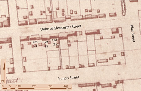 Figure 4. Detail of 1782 Frenchman's Map showing Lots 21, 22, and 23 on Block 9.
 Figure 5. Detail map of 1965-1967 archaeological excavations.
13
depicts only a single structure at this location. Nevertheless, the fact that they are on
located on different lots that were owned by separate owners, and the fact that separate
foundations were found on each lot, indicates that the structures were most likely
unrelated to one another.
Figure 5. Detail map of 1965-1967 archaeological excavations.
13
depicts only a single structure at this location. Nevertheless, the fact that they are on
located on different lots that were owned by separate owners, and the fact that separate
foundations were found on each lot, indicates that the structures were most likely
unrelated to one another.
Documentary evidence suggests that James Martin, a barber, may have occupied the structure on the northeast corner of Lot 21 adjacent to Wetherburn's Tavern from ca. 1755 through 1765. (Brown 1986:12-14). Nearly a decade later, John and William Rowsay's jewelry shop was located in this same structure. An advertisement for their shop identifies its location as "the next Door below Mr. Anderson's Tavern" (Virginia Gazette, Purdie, June 4, 1774). At the time of the advertisement, Mr. Anderson's Tavern was located on Lot 21 in the structure formerly occupied by Henry Wetherburn.
In the adjacent structure to the east, the documentary record indicates that James Slate, a tailor from London, was probably a tenant in the small structure on the northwest corner of Lot 22. In July 1774, Slate placed the following advertisement announcing the opening of his business:
JAMES SLATE, TAILOR from London, begs Leave to inform the Publick that he has just opened Shop the second Door below Mr. Anderson's Tavern, where he carries on his Business in all its Branches and will be much obliged to those who may please to favour him with their Custom(Virginia Gazette, Purdie & Dixon, July 19, 1774).
As already mentioned, Mr. Anderson's Tavern was located on Lot 21, and immediately to the east of the tavern stood a small shop building that was occupied by John and William Rowsay's jewelry shop. Thus Slate's shop, which was located at "the second Door below Mr. Anderson's Tavern," would have been situated in the small shop, to the east of Rowseys and on the west end of Lot 22.
Slate is known to have been in Williamsburg between 1774 and 1781, during which he is listed on the Roll of Members of the Williamsburg Lodge of Masons (William and Mary Quarterly, 1st s., 1:27). It is presumed that his shop remained on Lot 22 throughout his residency in Williamsburg. During the Revolutionary War, Slate was contracted to make uniforms for the Continental Army. On March 4, 1776 he was authorized to produce, "a sett of colours for the Mecklenburg Minute Batt" (Calender of Virginia State Papers, 1890:107) >, and again on April 5, 1776 to produce "H. Shirts and Leggins for Capt. Richardson's Comp'y" (Calendar of Virginia State Papers, 1890:153) . His business was evidently successful enough for him to advertise in June 1776 for "THREE journeymen TAILORS, who understand their business…" (Virginia Gazette, Purdie, June 22, 1776) . In that year, Slate also advertised for a lost or stolen horse (Virginia Gazette Purdie, July 4, 1776). Sometime between 1781 and 1784, Slate moved from Williamsburg to Richmond, most likely in order to take advantage of the relocation of the capital to Richmond. In 1784, Slate is listed in the Richmond city census, confirming that he was no longer living in Williamsburg by that date.
The Charlton Heirs (1785-1795)
When Edward and Jane Charlton had conveyed their house and property on Lot 22 to Richard Charlton's estate, Williamsburg was no longer the center of government 14 and commerce as it had been for most of the first three quarters of the eighteenth century. After the gaining independence from Great Britain, the capital of Virginia was moved further up the James River to Richmond. The effect of the capital's removal was a virtual stagnation of the local economy. When the capital moved to Richmond, so did many of Williamsburg's merchants and tradesperson, among them was James Slate, the tailor that had operated his shop on Lot 22 since 1774.
Richard Charlton's widow, Sarah Charlton, and her children probably moved into the house on Lot 22 sometime between her husband's death in 1779 and 1784 when the property was transferred into the possession of her late husband's estate. In Richard Charlton's will, his children, Thomas, Edward, and Jane were named as heirs, while his wife Sarah, along with James Galt and Robert Prentis were made executors of the estate (Bullock and Tonkin 1957:73-74).
Williamsburg Land Tax records beginning in the year 1785 indicate that Richard Charlton's Estate was charged with "1 lot valued for tax purposes at £5." The value of the lot increased to £7.10 in 1786, to £18 in 1787, and finally to £20 in 1789. Richard Charlton's Estate continued to pay taxes on Lot 22 until 1795 when it was conveyed to William Russell (Stephenson 1957:11).
William Russell (1795-1812) and Catherine Russell (1812-1819)
William Russell was the husband of Jane Charlton's niece, Betsy Farrow. Russell was employed as a clerk, serving from ca. 1786 through 1803 as Clerk of the Eastern State Hospital. In addition, he served as Clerk of the Hustings Court of Williamsburg from 1783 until his death in 1812 (Stephenson 1957).
In 1796, one year after his purchase of Lot 22, William Russell insured the property with the Mutual Assurance Society (Figure 6). The property was described as "My wooden Buildings on the main Street at Williamsburg now occupied by myself situated between the lots of Philip Moody and the lot of Wm Rowsey in the county of York." According to the insurance plat, the property contained a two-story dwelling house of wood 44' by 29' valued at $1000, a one-story office of wood 30' by 26' valued at $150, and a one-story kitchen of wood 22' by 18' valued at $140. Additionally, the plat notes that the distance between the office and the dwelling house to be "within 12 feet." The plat also contains a significant error—the locations of the office and the kitchen are illustrated on the wrong side of the property. Ten years later, in 1806, Russell again insured the property (Figure 7), at which time all the structures were all placed in the correct locations. The values for the structures were listed as $3330 for the dwelling house, the office at $400, and the kitchen at $250 (Stephenson 1957).
Russell owned the property until his death in 1812, at which point the property descended to his daughter Catherine Russell. By 1819, Lot 22 was in the possession of Leonard Henley (Stephenson 1957:12).
The Henley and Servant Families (1819-1928)
Similar to William Russell, Leonard Henley worked as clerk, serving as Clerk of the
County and Superior Courts of James City, the corporation of Williamsburg, William
15
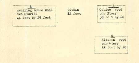 Figure 6. Copy of 1796 Mutual Assurance Society Map of Lot 22.
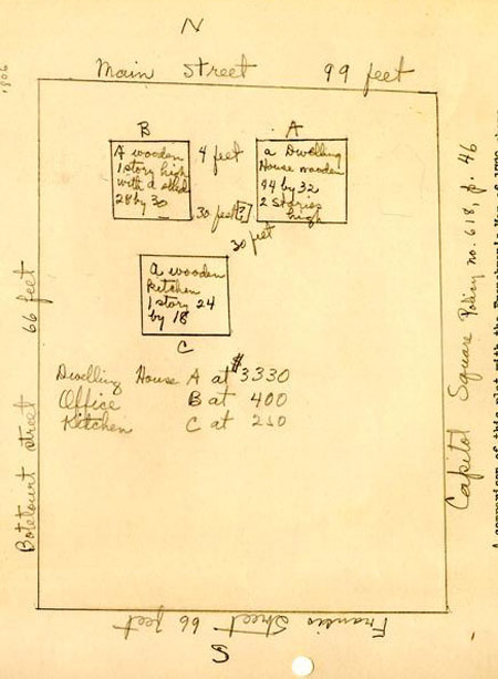 Figure 7. Copy of 1806 Mutual Assurance Society Map of Lot 22.
16
and Mary College, and the Eastern State Hospital. In 1819, Williamsburg Land Tax
Records list Henley with "1 lot valued at $100 via Catherine C. Russell—a certain
house and lot late the residence of said C.C. Russell." The following year, the value of
the property was increased to $1600 according the city land tax list. Evidently, the
substantial increase was for the buildings on the lot (Stephenson 1957), although the
buildings had already been built on the lot for some time.
Figure 7. Copy of 1806 Mutual Assurance Society Map of Lot 22.
16
and Mary College, and the Eastern State Hospital. In 1819, Williamsburg Land Tax
Records list Henley with "1 lot valued at $100 via Catherine C. Russell—a certain
house and lot late the residence of said C.C. Russell." The following year, the value of
the property was increased to $1600 according the city land tax list. Evidently, the
substantial increase was for the buildings on the lot (Stephenson 1957), although the
buildings had already been built on the lot for some time.
In 1823, Henley insured the property with the Mutual Assurance Society (Figure 8). The location of the property is given as, "My buildings on the main street in Williamsburg now occupied by myself situated between the lot of William McCandlish on the East, Francis Powell's lot on the West, and the Streets otherwise in the county of York." According to the insurance plat, only the dwelling house, insured at $2500, and the kitchen, insured at $200, remained standing, suggesting that the office has been pulled down (Stephenson 1957).
Seven years later, in 1830, the value of Henley's structures on Lot 22 were reevaluated and the value of the dwelling house being reduced to $1700, while the value of the kitchen remained at $200. The 1830 plat also illustrates a wooden smokehouse directly north of the kitchen, but assigns no monetary value to it. Henley's neighbors are listed as "Martha Magill on the West, Jacob Sheldon & Co on the East."
Henley died in 1831, at the age of 43 of an unnamed "painful disease," and was survived by his wife, Harriet, and eight small children. Henley's heirs continued to own the property after his death, and reinsured the property in 1839, 1846, 1853, and 1860. The Henley's continued to own and occupy the property until 1880, when the property was ordered to be sold following a lawsuit of the Mutual Assurance Society against the heirs of Leonard Henley. R.L. Henley purchased the property, as trustee for Ella J. Henley and children. However, a default in payment resulted in the sale of the west half of the lot to R.B. Servant in 1886, with the east half of the lot being retained by R.L. Henley. The heirs of Servant conveyed the property to Colonial Williamsburg in 1928.
Considerable architectural changes were wrought upon the Charlton House in the nineteenth century. The most significant was a reduction in the depth or width of the house. The house's depth had been reduced to nearly half of its original dimension according to evidence recovered from an architectural investigation of the house conducted in 1930. Evidently, the house had been cut in two along its east-west axis for the full length of the building, leading the investigators to conclude that the original chimneys of the house were demolished when the size of the house was reduced. The date of the change in the house plan is unknown, although it likely occurred sometime in the first half of the nineteenth century. Other notable architectural changes included the replacement of the original windows, replacement of the front door and transom, a low-sloped roof, and a jigsaw ornamented and spindle columned front porch set on brick piers (Figure 9). By the end of the nineteenth century, the size of the house was expanded with the construction of several small projecting bays and wings supported on brick piers appended to the rear of the house (Figures 10 and 11; Kocher and Dearstyne 1950:1-6).
17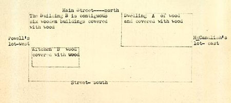 Figure 8. Copy of 1823 Mutual Assurance Society Map of Lot 22.
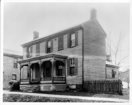 Figure 9. Circa 1928 photograph of the Charlton House, north elevation.
 Figure 10. Circa 1928 photograph of the Charlton House, south elevation.
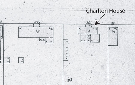 Figure 11. 1904 Sanborn fire insurance map of Lot 22.
Colonial Williamsburg Foundation (1929-present)
During Colonial Williamsburg's restoration of the Charlton House in 1929-30, the many nineteenth-century additions and modifications were removed, and the building was restored to its eighteenth-century dimensions and exterior appearance, with the exception of a serving pantry added to the west side of the house at the request of the then life tenant, Mary Lou Servient (Figure 12; Kocher and Dearstyne 1950:1-6). The addition of the serving pantry was eventually removed, presumably after the tenant vacated the house. The room arrangement on the first floor reflects the house's eighteenth-century layout, based on an examination of the structures foundations, while the second floor to the house was arranged for modern convenience (Bullock 1959). The house is currently operated as a residential rental property.
 Figure 12. Photograph of the reconstructed Charlton House (circa 1930s).
Chapter 2.
Previous Archaeological and Architectural
Investigations
1929-1930 Architectural Investigations
Shortly after acquiring the Charlton House property in 1928, the house was restored under the direction of Perry, Shaw and Hepburn's resident architect, Walter Macomber, and supervised by George Cambell with assistance from A.E. Kendrew, S.P. Moorehead and Milton L. Grigg. The restoration work occurred between October 1929 and March 1930, although a report on the work was not prepared until twenty years later by A. Lawrence Kocher and Howard Dearstyne (1950). According to their report, which was based on the notes and drawings of the original restoration architects, no archaeological excavations were carried out in 1929-30. However, the report does clearly indicate that a significant amount of (non-archaeological) digging was done all around the house, especially to the rear (south elevation). As discussed in the previous section, the depth or width of the Charlton House was reduced by nearly half and several additions were appended to the rear of the structure in the nineteenth century. Therefore, as part of the effort to restore the Charlton House's eighteenth-century dimensions, the nineteenth-century additions were removed, and excavations to locate the original eighteenth-century foundation walls were carried out. Those excavations successfully located the eighteenth-century extent of the Charlton House's foundations, upon which the rear portion of the house was reconstructed (Kocher and Dearstyne 1950).
In the examination of the Charlton House's brick foundations, the architects were able to identify three distinct construction phases in the brickwork—all thought to date to the eighteenth century. The first phase of construction, which was probably delineates the size of the original house, is located in the northwest portion of the reconstructed house. This early building was evidently of relatively modest dimensions, consisting of a single room measuring only 24 x 16 feet with a chimney along its west end. The second phase of construction consisted of a 14-foot-wide addition to the south, probably initially consisting of a lean-to, giving the house its present depth of approximately 28 feet. The subsequent third phase of construction consisted of an addition to the east increasing the house width to 44 feet along Duke of Gloucester Street. As part of the third phase, a second chimney was constructed at the center of the east wall (Kocher and Dearstyne 1950:2; Bullock 1959). Unfortunately, only a relative chronology of the changes in the foundation brickwork was established, and the actual dates for when these alterations and additions were made remains undetermined.
1933 Cross Trenching
Although no archaeological excavations were conducted on Lot 22 around the Charlton
House, archaeological cross trenches were excavated circa 1933 in the northwest
end of Lot 23, abutting against the east elevation of the Charlton House (Figure 13).
22
 Figure 13. 1933 Cross-trenching plan map of Lot 23 (hatching indicates cross-trenched areas).
The excavations were carried out under the supervision of Herbert S. Ragland, and
comprised of narrow trenches one shovel blade width thick, and spaced one shovel
length apart, oriented at a 45-degree angle to the town grid. The trenches were dug
with the objective of locating the remains of brick foundations. If the crews hit a
foundation wall, they then followed along the walls to expose the wall and to locate its
corners and any other walls. On the northwest corner of Lot 23, the goal of the cross
trenching was to find the foundations of a barber shop indicated on 1796 and 1806
insurance plats of the property (Ragland 1933:7).
Figure 13. 1933 Cross-trenching plan map of Lot 23 (hatching indicates cross-trenched areas).
The excavations were carried out under the supervision of Herbert S. Ragland, and
comprised of narrow trenches one shovel blade width thick, and spaced one shovel
length apart, oriented at a 45-degree angle to the town grid. The trenches were dug
with the objective of locating the remains of brick foundations. If the crews hit a
foundation wall, they then followed along the walls to expose the wall and to locate its
corners and any other walls. On the northwest corner of Lot 23, the goal of the cross
trenching was to find the foundations of a barber shop indicated on 1796 and 1806
insurance plats of the property (Ragland 1933:7).
The cross trenching adjacent to the Charlton House ultimately located a rectangular brick foundation bonded with shell tempered mortar measuring 16 x 20 feet in size that enclosed an unpaved basement 5 feet deep. The brickwork included a "great variety of brickwork" suggesting that the building was modified or expanded in several phases. The foundation closely matched the structure described in the aforementioned insurance plats, thus leading Ragland to conclude that they had found the 1796 barber shop (Ragland 1933:7-8). The date of the structure's construction, however, was undetermined.
1966 Archaeological Excavations
During the archaeological excavations of the Wetherburn's Tavern Property (Lot 21) in 1965, excavators exposed a tenement building (Building East A) on the east side of the tavern that appeared to abut another structure to the east on Lot 22. It was decided to explore the archaeological remains of the building to the east the following Figure 13. 1933 Cross-trenching plan map of Lot 23 (hatching indicates cross-trenched areas). 23 summer, leading to the first large-scale archaeological excavation of any part of Lot 22. Glenn Kirk carried out the archaeological excavations of Lot 22 in the summer of 1966, under the supervision of Colonial Williamsburg head archaeologist Ivor Noël Hume. Kirk's investigations were restricted to the northwest portion of Lot 22, in the area to the west of the Charlton House, and extending south to the Charlton Kitchen, thus leaving the vast majority of Lot 22 unexplored (Figures 14 and 15).
The excavations carried out by Kirk revealed the foundations of not just one but two buildings—one overlaying the other. Evidence of the first period building was scarce, consisting of only portions of the west and south walls of the structure (Figure 16). It was assumed that the north and east walls had been eradicated by later construction. Based on the assumption that the first period building and the second period building had approximately the same north wall line, it was calculated that the structure would have been 20'10" deep. The building's maximum determinable width was 15'3". Artifacts from the structure's builder's trench, and an accompanying debris layer suggested a construction date in the second quarter of the eighteenth century (Kirk 1967:14- 16).
The excavations further revealed evidence that the first period building was expanded
by an addition to the rear that was probably set on piers, increasing the
structure's depth by an additional 10'0". The base of a corner chimney was also found
in the northeast corner of the addition, with the fireplace facing the west wall and
southwest corner of the addition. The absence of a chimney in the original structure,
and the inclusion of one within the addition, led Kirk and Noël Hume to speculate that
a change in the use of the building had occurred that required the corner chimney and
 Figure 14. 1966 photo of Charlton House excavations.
24
Figure 14. 1966 photo of Charlton House excavations.
24
 Figure 15. 1966 photo of Charlton House excavations.
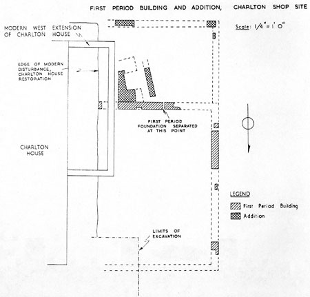 Figure 16. Plan of first-period building archaeological features (Figure 1, G. Kirk 1967).
25
rear addition's construction. No features or additional information regarding the use of
building was uncovered. Based primarily on the early construction date, Kirk suggested
that the first period building might be the warehouse listed in the deed which
marked the transfer of the property from James Crosby to Alexander Archibald
Buchanan & Company in 1749-50 (Kirk 1967:16-19).
Figure 16. Plan of first-period building archaeological features (Figure 1, G. Kirk 1967).
25
rear addition's construction. No features or additional information regarding the use of
building was uncovered. Based primarily on the early construction date, Kirk suggested
that the first period building might be the warehouse listed in the deed which
marked the transfer of the property from James Crosby to Alexander Archibald
Buchanan & Company in 1749-50 (Kirk 1967:16-19).
Kirk determined that the first period building was taken down only shortly before the construction of the second period building as indicated by the lack of demolition debris from the first period structure, and the lack of any soil or artifacts between the occupation layers between the two buildings. It was also hypothesized that the original building may have been incorporated into the second building. The lack of artifacts, however, precluded a reliable determination of a demolition date for the first period structure (Kirk 1967:16-19).
As already mentioned, the second-period building west of the Charlton House on Lot 22 was built directly over the remains of the first period building. The damaged portions of the brick foundation walls on all four sides of the structure were exposed during the 1966 excavations. The total depth of the second period building was 30'0" and its width 26'0", with a large chimney base and wall separating the northern two-thirds of the structure from the southern third (Figure 17). Kirk noted, with regard to the chimney base, "the bottom four (brick courses) were laid in a regular manner while the upper two courses were set in a curved arrangement which might suggest that there could have been some sort of oven instead of a fireplace… [that] might have been used for preparing wigs" (Kirk 1967:22) . The original south wall of the first period building appears to have been reused as a footing for the dividing wall in the second period building. A variation in the brickwork to the south of the dividing wall in the east foundation of the building suggests that the southern third of the structure may have originally been a shed rather than a continuation of the north portion. The footings of a stoop were found positioned off center to the west along the north elevation (front) of the building. The stoop was positioned 5'9" from the building's northwest corner of the building and 11'3" from its northeast corner. The stoop foundation was built primarily of brick bats, measuring 9'0" wide and 4'2" deep. In addition, a brick pier within the interior of the building, probably used to provide support for a wood floor, was also found (Kirk 1967:20-24).
Evidence of the second period building's construction date indicates that the structure was built around 1770, or shortly thereafter. Logically, this would also indicate that the demolition of the first period building probably occurred during this period immediately before the construction of the second period building (Kirk 1967:25). Among the artifacts recovered during the excavation, Kirk noted "the presence of wig curlers in the vicinity of the second building" (Kirk 1967:25) . The recovery of the wig curlers in association with property owned by Edward Charlton, a well-known wigmaker, and the unusual construction of the hearth/oven led Kirk to conclude that his was the site of Edward Charlton's shop (Kirk 1967:25). Through a combination of archaeological data and documentary sources the demolition date for the second period building was determined to be circa 1820 (Figure 18; Kirk 1967:30-31).
In addition to the excavation of the two structures, Kirk's excavations also explored
the reconstructed Charlton smokehouse to the north of the kitchen and near
26
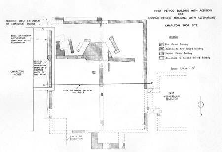 Figure 17. Plan of second-period building archaeological features (Figure 2, G. Kirk 1967).
the west property line, as well as an abandoned well to the east of the smokehouse.
Figure 17. Plan of second-period building archaeological features (Figure 2, G. Kirk 1967).
the west property line, as well as an abandoned well to the east of the smokehouse.
No clear evidence of a colonial smokehouse was found in Kirk's excavations, suggesting that the reconstructed building may be in the wrong location. Investigation of the well determined a terminus post quem date to be 1858, based on a flying eagle penny recovered from the top fill layer of the well, but the date the well was first dug remains undetermined (Kirk 1967:31-34). Finally, Kirk's excavations also recovered evidence of fence lines, yard areas, and portions of four brick drains, three of which were constructed in the nineteenth century and cut through the ruins of the second period building (Kirk 1967:36-39).
1999 Archaeological Excavations
No additional archaeological investigations of Lot 22 took place again for more than
thirty years. In November 1999, archaeological excavations were carried out by archaeologist
Lisa Fischer, under the direction of Marley R. Brown III, Director of
Archaeological Research at Colonial Williamsburg. Archaeological trenches were excavated
behind the east half of the Charlton House and extended south to the Charlton
Dairy on Lot 22, and to the south of the reconstructed King's Arms Tavern Barber
Shop on Lot 23 (Figure 19). These excavations were carried out in preparation for
27
 Figure 18. Profile drawing of the stratigraphy across
the Second Period Building (Figure 3, G. Kirk 1967).
28
Figure 18. Profile drawing of the stratigraphy across
the Second Period Building (Figure 3, G. Kirk 1967).
28
 Figure 19. Location of the archaeological trenches excavated in 1999.
the installation of new utility lines into the buildings. Unfortunately, the results of the
excavations were hindered by extensive modern utility and garden disturbances. The
construction (and demolition) of the nineteenth-century additions to the rear of the
Charlton House further limited the identification of eighteenth century contexts. In
spite of these disturbances, several intact eighteenth-century soil layers and features
were encountered and excavated (Fischer n.d.).
Figure 19. Location of the archaeological trenches excavated in 1999.
the installation of new utility lines into the buildings. Unfortunately, the results of the
excavations were hindered by extensive modern utility and garden disturbances. The
construction (and demolition) of the nineteenth-century additions to the rear of the
Charlton House further limited the identification of eighteenth century contexts. In
spite of these disturbances, several intact eighteenth-century soil layers and features
were encountered and excavated (Fischer n.d.).
The most significant result of the 1999 excavations was the scarcity of wigmaking related artifacts from any of the excavated contexts. This scarceness was particularly notable in view of the fact that the current interpretation of the King's Arms Tavern Barber Shop as an eighteenth-century wigmaker's shop. Previous excavations of wigmaker's shops had resulted in large quantities of wigmaking artifacts, thus it was hypothesized that if the King's Arms Tavern Barber Shop had been in fact a wigmaking shop, a much larger quantity of wigmaking related artifacts would have been recovered. As a result, due to the lack of artifacts, Fischer called into question the accuracy 29 of the shop's interpretation. The lack of archaeological evidence for wigmaking at the shop was further reinforced through a re-examination of the documentary evidence that had previously been cited as evidence for wigmaking at the shop. Ultimately the re-examination of the documentary record proved equally unconvincing with regard to the shop's interpretation as a wigmaker's shop (Fischer n.d.).
Summary
The previous research regarding Lot 22 has been almost exclusively been limited to the portion of the property fronting along Duke of Gloucester Street. Thus far no investigations have been carried out along the southern portion of the lot. Similarly, investigation of the Charlton House has been limited to a single architectural investigation carried out during the building's restoration in 1930, which included the non-archaeological excavation of the area around the house to locate eighteenth-century foundations. While the architects at the time were able to recover information for the building's reconstruction, the report on their investigations notes their inexperience at this early date in the restoration of Williamsburg: "This was one of the first buildings to be restored and it is possible that the techniques of investigation and discovery of evidence lagged somewhat at this time" (Kocher and Dearstyne 1950:3). No archaeological investigations specifically oriented to recovering information regarding the house have been attempted prior to 2002, although previous limited archaeological investigations of the property (Ragland 1933; Kirk 1966; Fischer n.d.) have recovered substantial information on the smaller shops, offices, and outbuildings that flanked the Charlton House.
30Chapter 3.
Research Design/Methods
In anticipation of the Charlton House's waterproofing, the Department of Archaeological Research conducted an archaeological investigation of the areas around the exterior of the house to be impacted by the waterproofing excavations. As part of the investigation, trenches measuring approximately two meters wide were hand excavated along the structure's north, south and west elevations. To the east of the Charlton House, the narrow alley between the house and the reconstructed King's Arms Barber Shop was not excavated due to significant previous ground disturbances at that location during the reconstruction of the King's Arms Tavern Barber Shop (Figure 20).
Both horizontal and vertical controls were employed over the excavations around the Charlton House. Horizontal control was achieved via a Cartesian grid, placed at one-meter intervals across the site. Each grid square was identified by the north and east coordinates of the northwest corner of each grid square. For record keeping purposes, each separate soil layer or distinctive feature within the excavation area was assigned its own unique context number by which it could be identified. In order to maintain vertical control over the site, each soil layer or feature was stratigraphically excavated, using shovels and trowels, following the natural contours and boundaries of the layers and features. Differentiation between the different layers and features was recognized by changes in the soil type, color, and texture. Equally important was the recordation of the stratigraphic relationships between the different soils and features. To accomplish this, a Harris matrix illustrating the stratigraphic relationships of each context was compiled in the field.
The excavation of each trench was continued until undisturbed subsoil was reached. All pre-restoration soils were passed through one-quarter-inch hardwire mesh screens to recover any artifacts. In the field, each soil layer or feature was mapped, photographed, and described in detail on standardized Department of Archaeological Research Context Record Sheets. All the field records were subsequently imputed into Re:Discovery, the collections management computer database used by the D.A.R.
All of the recovered artifacts and faunal remains were bagged in the field by context and sent to the laboratory for processing and analysis. At the lab, the artifacts were washed, identified, and inventoried according to provenience. The artifacts were inventoried using standard descriptive typology with all the obvious functional and morphological characteristics noted and entered into Re:Discovery. Based on the artifacts, each context was assigned a terminus post quem (TPQ), using the artifact with the most recent first manufacturing date. The TPQ date represents the date after which the context was deposited.
Faunal materials were also analyzed using standardized zooarchaeological laboratory procedures developed by D.A.R.'s Zooarchaeology Laboratory. Analysis of the faunal remains began with sorting the faunal fragments into "identifiable" and "unidentifiable" categories. By working with the comparative collection, the "identifiable"
32
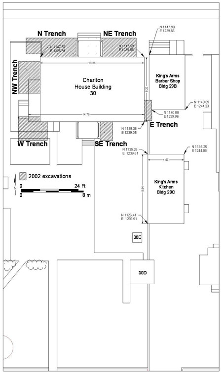 Figure 20. Location of the archaeological trenches excavated in 2002.
bone fragments were identified to the lowest taxonomic level possible, bone element, symmetry (side), location, weight, fusion state, tooth type and wear, and relative age. The data was recorded and entered into the zooarchaeological lab's customized database computer program.
Figure 20. Location of the archaeological trenches excavated in 2002.
bone fragments were identified to the lowest taxonomic level possible, bone element, symmetry (side), location, weight, fusion state, tooth type and wear, and relative age. The data was recorded and entered into the zooarchaeological lab's customized database computer program.
The quantification of the faunal material and an estimation of the dietary importance of various species can be determined using several different specialized techniques which have been developed by zooarchaeologists. The methods used in this analysis include Number of Identified Specimens (NISP) and Biomass estimates. NISP involves a simple count of the total number of elements. Although commonly used; this method is not without its shortcomings. Most notably is the failure of NISP counts to account for element interdependence, differential preservation, difficulty of identification of certain elements, and differences in recovery methods (Grayson 1984). The most important alternative to the NISP method is the "minimum number or individuals" (MNI) method, which provides an estimation of the smallest number of live animals that could have accounted for the recovered bone. Grayson (1984), however, has shown that the 33 MNI method is also seriously flawed. Particularly for small samples, MNI tends to over-inflate the importance less common species and thus provides a skewed picture of their true dietary significance. With these limitations in mind, combined with the small sample sizes of the faunal material from the site, no MNI count was calculated for the Charlton House assemblages.
The second method used for estimating dietary importance with the Charlton House assemblage is the "skeletal mass allometry" or "biomass" method (Reitz and Cordier 1983). This method relies on meat weight figures based on the weight of the bone itself, and rests on the basic principle of allometry-that any two dimensions of an animal grow in a relatively predictable exponential curve, and thus one can construct an equation that relates the two.
Once the artifact and faunal analyses were completed, the respective assemblages and their accompanying documentation were prepared for log-term curation. All of the field documentation, artifacts, and artifact information are currently stored at the D.A.R. Laboratory.
34Chapter 4.
Research Results
In spite of extensive ground disturbances, which occurred as a result of nineteenth-century remodeling, the renovation of the house in the 1930s, the installation of modern utility lines into the house, and previous archaeological excavations; the 2002 archaeological investigation of the house proved to be very productive with regard to understanding the property and the surrounding landscape as it developed from the seventeenth through the late nineteenth centuries. Highlighting some of the most significant discoveries include the identification of an unusually large ditch feature that is believed to have served as a seventeenth-century boundary or drainage ditch; a line of very large postholes which are believed to have supported the wall of a large earthfast barn or warehouse during William Byrd II's ownership of the lot in the first half of the eighteenth century; the corner of a narrow brick foundation for a small structure constructed around the middle of the eighteenth century; the brick foundation and demolition debris from a late eighteenth-century tailor's shop that stood to the west of the Charlton House; and the heavily disturbed fragments of a brick paved sidewalk along Duke of Gloucester Street in front of the Charlton House. In addition, numerous cultural layers and features relating to all phases of the property's occupation were uncovered all around the house in the course of the archaeological excavations.
Middle Plantation-Period Features
In comparison with the extensive historical research and numerous excavated archaeological sites from eighteenth-century Williamsburg, only scant traces of the seventeenth-century community of Middle Plantation are known. Amongst the few notable Middle Plantation-period sites recently studied are the John Page Site (Metz et al. 1998), the Nassau Street Ordinary (Levy 2000), the College Landing site (Edwards 1987), and Rich Neck Plantation (McFaden et al. 1999). In addition, a small number of isolated Middle Plantation-period archaeological features have also been encountered throughout Colonial Williamsburg's Historic Area in the course of investigations of later eighteenth-century sites such as the Shields Tavern site (Brown et al. 1990:37), the Peyton Randolph site (Edwards et al. 1988:116) and the Nicholas-Tyler site (Klingelhofer 1980:2). The archaeological excavations at the Charlton House in 2002 identified one such isolated feature, a large boundary or drainage ditch.
Boundary/Drainage Ditch (M1)
The Middle Plantation-period ditch feature found at the Charlton House was cut directly into the sterile subsoil and was oriented along a linear NE to SW axis through the project area (Figure 21). The ditch was located at the lowest stratigraphic level, sealed under a relatively thick layer of intact early eighteenth-century sheet refuse. Two separate sections of the ditch feature were found in the course of the excavations, one lying to the west of the extant Charlton House, and the second to the north of the
36
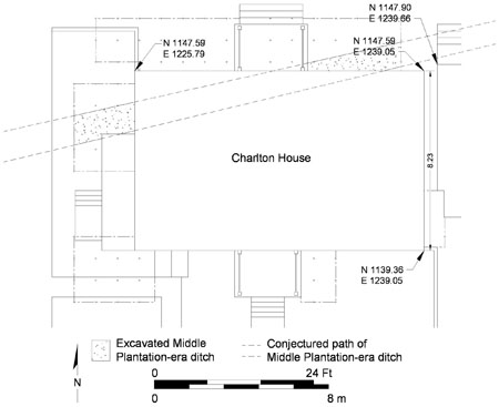 Figure 21. Plan of the Middle Plantation boundary/drainage ditch feature.
house. Although discontinuous, the two sections were oriented along the same alignment and were clearly part of the same feature with the intermediate section having been destroyed in the mid-eighteenth century as a result of the excavation of the Charlton House's basement. The fact that the basement excavation cut through the ditch clearly indicates that the ditch pre-dates the construction of the house and was no longer in use by that date. Equally significant in determining the age of the feature was the fact that the ditch was not oriented along the north-south/east-west town grid to which nearly all of Williamsburg's eighteenth-century structures, roads, fence lines, and other man-made landscape features are aligned. The combination of each of these factors-intruding only subsoil, irregular orientation, and being sealed under a layer of early eighteenth-century plowzone-strongly suggests that the ditch dates to the Middle Plantation period rather than to the Williamsburg period (see Figure 22 for the ditch in relation to other known Middle Plantation features).
Figure 21. Plan of the Middle Plantation boundary/drainage ditch feature.
house. Although discontinuous, the two sections were oriented along the same alignment and were clearly part of the same feature with the intermediate section having been destroyed in the mid-eighteenth century as a result of the excavation of the Charlton House's basement. The fact that the basement excavation cut through the ditch clearly indicates that the ditch pre-dates the construction of the house and was no longer in use by that date. Equally significant in determining the age of the feature was the fact that the ditch was not oriented along the north-south/east-west town grid to which nearly all of Williamsburg's eighteenth-century structures, roads, fence lines, and other man-made landscape features are aligned. The combination of each of these factors-intruding only subsoil, irregular orientation, and being sealed under a layer of early eighteenth-century plowzone-strongly suggests that the ditch dates to the Middle Plantation period rather than to the Williamsburg period (see Figure 22 for the ditch in relation to other known Middle Plantation features).
The exposed portion of the ditch extended approximately 15.4 meters (51 feet), including the portion destroyed by the basement excavation, and continued out of the archaeological trenches to the northeast and the southwest, thus prohibiting a determination of the feature's full length. All portions of the ditch feature that were exposed in 2002 were fully excavated; however only at its southwest end was the full width of the feature evident, measuring 1.2 meters (4 feet) wide. The northeastern end of the ditch existed only partially intact on account of the disturbance from the excavation of the Charlton House basement, thus barring a measurement of the ditch's width at its north
37
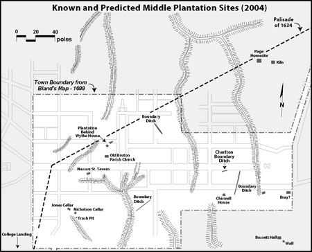 Figure 22. Known Middle Plantation-period archaeological features.
eastern end. Both sections of the ditch were excavated to subsoil, and both contained only a single homogeneous layer of brown to dark brown silt loam fill (Munsell color 10YR4/4). Artifacts recovered from the ditch fill consisted of only a single wrought nail fragment and three wrought iron strap fragments. Two brickbats and a number of small brick fragments were also recovered from the fill, but were not retained. Interestingly, all the artifacts, as well as the brick fragments, were recovered from the southwestern section of the ditch, while no artifacts or brick was recovered from the northeast section. The scarcity of artifacts associated with the ditch is consistent with similar Middle Plantation-period ditch features excavated at the Shields Tavern and Peyton Randolph sites that similarly contained few artifacts.
Figure 22. Known Middle Plantation-period archaeological features.
eastern end. Both sections of the ditch were excavated to subsoil, and both contained only a single homogeneous layer of brown to dark brown silt loam fill (Munsell color 10YR4/4). Artifacts recovered from the ditch fill consisted of only a single wrought nail fragment and three wrought iron strap fragments. Two brickbats and a number of small brick fragments were also recovered from the fill, but were not retained. Interestingly, all the artifacts, as well as the brick fragments, were recovered from the southwestern section of the ditch, while no artifacts or brick was recovered from the northeast section. The scarcity of artifacts associated with the ditch is consistent with similar Middle Plantation-period ditch features excavated at the Shields Tavern and Peyton Randolph sites that similarly contained few artifacts.
The excavation of the ditch fill revealed a distinctive difference in the depth to which each end of the ditch intruded into the dense clay subsoil. The depth of the southwestern end of the ditch measured only 0.2 meters (0.65 feet) deep, while the northeastern end measured 0.7 meters (2.3 feet) deep. However, the difference in the relative elevation of the ditch's bottom measured only 10 cm (0.33 feet) from end to end for a slope of 65 mm per meter (.0064 feet per foot), with the northeast end being lower than the southwestern end. Although the slope of the ditch was slight, the fact that someone took the trouble to excavate the ditch so deep through the clay subsoil at one end and not the other suggests that the gentle slope was intentionally engineered.
In comparison with the Middle Plantation-period ditches found at the Peyton Randolph site, Shields Tavern, or the Nicholas-Tyler site, none were observed to 38 have any discernible slope. Generally, these features have been interpreted as boundary lines delineating property divisions. Similar ditch features are also well-known from other seventeenth-century sites outside of Williamsburg, including Martin's Hundred (Noël Hume 2001), Kingsmill (Kelso 1984), and Governor's Land (Outlaw 1990). In most of these examples, the ditches were also interpreted as property boundary markers or as internal property divisions.
In contrast, excavations at the John Page site revealed a sloped ditch that has been hypothesized to have been used for irrigation purposes relating to a small industrial complex for brick and tile manufacturing. The slope of the Page irrigation ditch descended four feet over the trench's 300-foot length (slope = 0.0133/1.0 feet), apparently in order to lead water from a distant spring in to the site (Metz et al. 1998:41-42). Assuming the slope of the ditch at the Charlton House remained at a constant, the ditch would descend a total of two feet over the same 300-foot length. Although not as dramatic as the Page ditch, the fact that any slope was evident in the Charlton House ditch likewise suggests that the ditch may have been designed to transport or direct water. The direction of the water transport, however, either to carry water to or away from the site, remains unknown. Given the similarities, it is an intriguing possibility that the Charlton ditch similarly relates to an as-yet-undiscovered industrial complex similar to the one found at the Page Site. As Middle Plantation grew more prominent in the late seventeenth century, it would be expected that various industrial and trade related sites would have been established in the vicinity to support Middle Plantation's small yet growing population.
A more conclusive determination of the ditch's function would require additional excavation (extending out of waterproofing project area) to determine the ends of the ditch, and to further measure its slope. Unfortunately, expansion of the project area to further delineate the ditch's length in 2002 was not feasible. While the function of the ditch as either a boundary or irrigation feature remains ambiguous, its significance is derived from the fact that it represents one of only a handful of features that can be reliably attributed to the poorly understood pre-Williamsburg period (pre-1699). In addition, the fact that ditches are among the most common seventeenth-century features discovered in Williamsburg suggests that they were significant elements on the Middle Plantation landscape. The growing database of Middle Plantation archaeological evidence is beginning to illustrate how in addition to the construction of structures, the residents of Middle Plantation were deliberately manipulating their environment via the excavation of these ditches for a variety of purposes in order to transform the area's wilderness into an environment suitable for settlement that was consistent with the needs and pre-conceptions of the colonists.
Shields, Byrd, and Crosby-Period Features
After the founding of Williamsburg in 1699, half-acre lots were laid out within the newly surveyed town that could be purchased or granted from the trustees of the city. Documentary evidence suggests that Lot 22 was originally conveyed from the trustees of the city to James Shields, a local tailor and tavern keeper. Shortly thereafter, Shields conveyed the lot (along with Lots 23 and 24) to William Byrd II, who owned the three lots for most of the first half of the eighteenth century. By 1749/50 James Cosby was 39 the owner of Lot 22, but the date of his acquisition has not been determined thus far. Given the small size of the project area, and the lack of documentary evidence of any substantial occupation of the property during this time period, the archaeological evidence regarding the early eighteenth-century development of the lot was surprisingly abundant. The evidence included a distinct layer of early sheet refuse, a fence line, and a large post-in-ground structure.
Early Sheet Refuse Layer (M2)
Sheet refuse, or a sheet midden as it is sometimes known, is an aggregate feature formed in part by the daily discard behavior of a site's occupants. The discarding of household refuse around a structure, or within a structure's yard, was a common and convenient method of disposing household refuse when below-ground features such as privies, wells, cisterns, or cellars were not available or were inconveniently located for receiving the everyday trash produced by a household. Accordingly, deposits of sheet refuse can be valuable sources of information about the material culture of daily life of a particular site's occupants (Versaggi 2000:45-47).
During the Charlton House excavations, an early layer of sheet refuse was found which represented the earliest evidence of the property's occupation during the Williamsburg period (post-1699). The sheet refuse layer consisted of a stratum of olive brown silt loam (Munsell color 2.5Y4/3) that ranged in thickness from 10 to 36 cm (0.33 to 1.18 feet). The variation in the depth of the layer was as a result of twentieth-century utility lines displacing the upper portions of the layer. Intact portions of the layer were encountered along the north and west elevations of the house, but not along the southern elevation. The identification of this layer to the west of the Charlton House was surprising given the fact that this area had been previously excavated by Glenn Kirk in 1966. However, an examination of the field documentation revealed that the 1966 excavations were not always carried out all the way down to sterile subsoil. This turned out to be the case to the west of the Charlton House, where the excavators in 1966 stopped their excavations on the top surface of a layer they termed "Brown Subsoil" (Kirk 1967), which is evidently analogous to the early sheet refuse layer (M2) identified in 2002. The fact that they did not continue their excavations any further is also why they did not locate the earlier Middle Plantation-period ditch, which was buried beneath the early sheet refuse layer and ran diagonally through their project area.
As described above, along the south elevation of the house, no evidence of the early sheet refuse layer was identified. Most likely, all evidence of the layer was obliterated by the construction of the nineteenth-century additions to the house and the twentieth-century reconstruction excavations. Archaeological excavations carried out by Lisa Fischer in 1999 similarly did not find any evidence of this early sheet refuse layer at the southeastern corner of the Charlton House, although to the west of the lot, behind the reconstructed Kings Arms Tavern Barber Shop on Lot 23, a layer of dark yellowish brown sandy loam containing early eighteenth-century glass and ceramics was found with a TPQ of 1700 (Fischer n.d.). The early date for the layer indicates that it is contemporary with the early sheet refuse layers found in 2002 around the Charlton House.
40The early sheet refuse layer sealed the Middle Plantation-period drainage/irrigation ditch, as well as the sterile subsoil, to the north and west of the house. The layer contained a scatter of artifacts mixed with a small number of brick fragments and charcoal. The artifacts were typically found closer to the top of the layer while the bottom 5 to 10 cm of the layer directly above subsoil was nearly devoid of any artifacts. A total of 486 artifacts were recovered from the layer, consisting of a wide variety of late seventeenth and early eighteenth-century household refuse such as ceramics, glass, animal bone, personal items, as well as architectural debris such as nails and window glass (Table 1). Household refuse accounted for 79% of the artifact total from the layer, while architectural debris accounted for the remaining 21% of the artifacts. Where the debris came from, however, remains a mystery. Lot 22 is not known to have had any domestic occupation at this early date. One possibility is that the debris originated from one of the adjacent developed properties. The most likely point of origin is Lot 24, which had been developed as early as 1707.
Among the ceramics recovered from the layer, delftware and coarse earthenwares, ware types typically associated with food production and storage, made up the majority of the ceramic fragments. Stoneware fragments were also recovered, but in a substantially smaller quantity, although there did exist a great diversity in the number different stoneware ware types recovered including English, German, and American manufactured wares. The majority of the ceramic finds recovered were typically produced in the late seventeenth and early eighteenth centuries, although a small number of fragments of later ware types were also recovered (Philadelphia coarse earthenware and English Bristol stoneware). These fragments, however, are believed to not have been part of the original accumulation of the layer, and instead are believed to be intrusive artifacts, which were unintentionally introduced into the layer at a later date.
Of all the different artifacts, vessel glass was the most abundant artifact type recovered, accounting for nearly a quarter of the entire assemblage (Figure 23). Although primarily consisting of wine bottle glass, small quantities of table, container, and pharmaceutical glass were also recovered. Animal bone was also found in the layer, and accounted for 23% of the total assemblage. The bones undoubtedly represent the refuse from early eighteenth-century meals consumed on or very near Lot 22. A small number of personal items were also found, including a small clear leaded glass jewelry stone. Tobacco pipes accounted for the rest of the small quantity of personal items. Lastly, architectural debris consisting of mostly nails, a small number of window glass fragments, and a single slate fragment possibly used as roofing material, were all also recovered from the early refuse layer. Brickbats and brick fragments were also recovered but not retained.
The early sheet refuse layer artifact assemblage includes a wide variety of items manufactured in the late seventeenth and early eighteenth centuries. The most recent non-intrusive artifact from the assemblage was a piece of English dip-molded wine bottle glass, a technique of wine bottle glass manufacturing which has a terminus post quem of 1730. The artifacts from the layer all suggest that the sheet refuse layer had accumulated in the early eighteenth century, probably ever since the earlier drainage/irrigation ditch had silted in and was no longer in use, and continued to accumulate into the second quarter of the eighteenth century.
41| Total | Percent | |
|---|---|---|
| Tin Glazed | ||
| Delftware | 31 | 6.4 |
| Coarsewares | ||
| Red Sandy | 33 | 6.8 |
| Yorktown | 3 | 0.6 |
| Philadelphia | 1 | 0.2 |
| Stonewares | ||
| White Salt Glazed (dipped) | 1 | 0.2 |
| White Salt Glazed | 4 | 0.8 |
| Frechen | 1 | 0.2 |
| Fulham | 1 | 0.2 |
| Burslem | 2 | 0.4 |
| Yorktown-type | 1 | 0.2 |
| Westerwald | 2 | 0.4 |
| Nottingham | 1 | 0.2 |
| Other | 4 | 0.8 |
| Glass | ||
| Wine Bottle | 120 | 24.7 |
| Pharmaceutical | 3 | 0.6 |
| Container | 7 | 1.4 |
| Table | 4 | 0.8 |
| Tobacco Pipes | 37 | 7.6 |
| Architectural | ||
| Nails | 80 | 16.5 |
| Window Glass | 20 | 4.1 |
| Slate | 1 | 0.2 |
| Fuanal | 112 | 23.0 |
| Oyster Shell | 8 | 1.6 |
| Other | 9 | 1.9 |
| Total | 486 | 100.0 |
Early Fence Line (M3)
Utilized to define property boundaries and internal yard divisions (i.e., gardens, animal pens, etc.), fence lines on urban sites are important features for understanding the eighteenth-century cultural landscape. At the Charlton House, a single such fence line was found during the excavations to the north of the present house, oriented east-west, and parallel to Duke of Gloucester Street (Figure 24). The location and orientation of the fence line suggests that the fence delineated the northern margin of Lot 22.
The fence line consisted of a series of six postholes in a single line. Five of the postholes were approximately spaced at 2.6 meter (8.5 foot) intervals between one another. The sixth posthole identified within the line may have represented the location of a gatepost, since it did not conform to the regular spacing of the other five posts. In actuality, the postholes were located outside the limits of the project area, but were
42
 Figure 23. Artifacts from the early eighteenth-century sheet refuse layers.
visible in the north wall profiles of the archaeological trenches excavated across the north elevation of the Charlton House. Further complicating the investigation of the postholes was the fact that the posthole features remained only partially intact, as later eighteenth-century features had cut through many of the postholes, leaving only small sections of each of the postholes intact. Nevertheless, from what did remain of their profiles, it was clear that each of the postholes had been excavated through the early sheet refuse layer and into the sterile subsoil, thus post-dating the fenceline after the accumulation of the layer in the first quarter of the eighteenth century. Neither the end nor the corner posts of the fence line were determined, thus it has been assumed that the fence line continued to both the east and the west beyond the limits of the archaeological trenches.
Figure 23. Artifacts from the early eighteenth-century sheet refuse layers.
visible in the north wall profiles of the archaeological trenches excavated across the north elevation of the Charlton House. Further complicating the investigation of the postholes was the fact that the posthole features remained only partially intact, as later eighteenth-century features had cut through many of the postholes, leaving only small sections of each of the postholes intact. Nevertheless, from what did remain of their profiles, it was clear that each of the postholes had been excavated through the early sheet refuse layer and into the sterile subsoil, thus post-dating the fenceline after the accumulation of the layer in the first quarter of the eighteenth century. Neither the end nor the corner posts of the fence line were determined, thus it has been assumed that the fence line continued to both the east and the west beyond the limits of the archaeological trenches.
The sizes of postholes varied individually in width from 50 cm (1.64 feet) to 65 cm (2.1 feet), although they were all consistently excavated to a depth of 40 cm (1.3 feet) below the top surface of the early sheet refuse layer. Postmolds were evident in only the two easternmost postholes out of the six. The postmolds and measured 12 cm (0.4 feet) in diameter and had flat bottoms that corresponded with the bottom of their respective posthole. A small quantity of nail fragments, wine bottle glass, and animal bone was recovered from the posthole fills. The artifacts were of the same variety as those recovered from the layer of early sheet refuse, although none of artifacts could be attributed to a particular date.
43 Figure 24. Profile drawing of the Early Fence Line postholes (M3).
Earthfast Structure (M4)
Possibly the most exciting discovery of the 2002 excavations at the Charlton House was the identification of a previously unknown earthfast structure that dated to the first half of the eighteenth century. The discovery of the building is noteworthy not only because it is one of only a small handful of earthfast structures known within eighteenth-century Williamsburg, but also because its location directly on Duke of Gloucester Street (Willie Graham, personal communication).
Earthfast buildings have a long tradition in Virginia, dating to the earliest days of the colony at Jamestown. Recent research on the origins of the phenomenon suggests that the Chesapeake's earthfast buildings were local adaptations of a longstanding building tradition brought over from England (Carson et al. 1981; Deetz 2002). Briefly described, an earthfast structure is a timber framed structure that is built directly on the ground without the benefit of a brick or stone foundation. As part of the construction of an earthfast building, postholes are dug into the ground along the perimeter of the building into which the main vertical timbers of a structure's frame are seated. The postholes are then backfilled around the wooden posts to hold them in place.
Although the settlers at Jamestown did eventually build a number of brick buildings, countless archaeological excavations across the region have shown that as the colony expanded beyond Jamestown, the vast majority of structures built in the first century of the Virginia colony were earthfast (e.g., Kelso 1984; Noël Hume 2001). On the region's many plantations, earthfast buildings were used as dwellings, outbuildings, tobacco barns, warehouses, and stables, or for any other purpose that an individual might require. In addition to their multi-purposefulness, archaeological excavations over the last thirty years have shown that earthfast buildings were used as dwellings by nearly all segments of society from the very poor to the very rich (Carson et al. 1981). Not until the third quarter of the seventeenth century did the construction of brick dwellings emerge. Brick houses were built by the colony's elite to express their social rank and economic prosperity (Brown 1998:103). By the early eighteenth century, Georgian brick houses had almost completely replaced earthfast dwellings among the colony's elite, although earthfast houses remained common among the middling, poor and enslaved, who composed the vast majority of the colony's population. Nevertheless, even among the elite, earthfast buildings remained as a practical building option for plantation outbuildings, warehouses and stables.
In contrast to the prevalence of earthfast buildings in Williamsburg's surrounding rural countryside, few earthfast buildings are known from within the city limits. Their absence has traditionally been attributed to a distinction between urban and rural building preferences. While earthfast buildings were an acceptable form on the farm, city buildings were thought to have been constructed of brick, or with a minimum of a brick foundation. Until recently, archaeological research had seemingly supported this belief as very few earthfast buildings had been discovered in eighteenth-century Williamsburg. However, the lack of archaeological examples may just as likely be attributed to recovery biases related to excavation technique, as much as an actual lack of earthfast examples. From the 1930s to the 1950s archaeological cross trenches which were singularly focused on locating brick foundations were dug diagonally across much of 45 Colonial Williamsburg's Historic Area. Although the cross trenching method proved effective for locating the masonry ruins of brick buildings, ephemeral soil stain features related to earthfast buildings were not typically recorded, or even noticed during the cross-trenching campaigns.
Beginning in the 1950s, open area excavation blocks became standard practice at Colonial Williamsburg. At the same time, archaeologists in the greater Chesapeake were growing increasingly aware of the pervasiveness of earthfast buildings, and the archaeological remnants of these buildings. However, the focus of the bulk of the archaeological work at Colonial Williamsburg since the 1950s has been restricted to known eighteenth-century brick structures, thus selecting against the possibility of discovering earthfast buildings that may have stood among the brick ones. Recently, this situation changed somewhat with the large open-area excavations at the Douglass Theater site in the late 1990s, and at the James Wray site in 2002-03. In the course of both excavations, large earthfast buildings were discovered, although their functions varied considerably from one another. At the Douglass Theater site, located at the east end of town near the Capitol, the earthfast building found there was an elaborate two-story tall theater building dating to the period of 1760-80, complete with a stage area, seating area, and support rooms (Lisa Fischer, personal communication). At the other end of town, at the James Wray site, a series of eighteenth-century earthfast buildings were used for a variety of industrial associated functions including: a saw pit shelter, a large barn, brick drying shelter, and as storage buildings or workshops (Harwood et al. 2003:1-13). The results from both of these excavations, combined with the evidence from the Charlton House excavations suggests that earthfast buildings may have had a much larger role in the development of Williamsburg than has long been supposed. They were used for both public and private buildings, as well as, for both large and small buildings.
Beginning in the 1950s, open area excavation blocks became standard practice at Colonial Williamsburg. At the same time, archaeologists in the greater Chesapeake were growing increasingly aware of the pervasiveness of earthfast buildings, and the archaeological remnants of these buildings. However, the focus of the bulk of the archaeological work at Colonial Williamsburg since the 1950s has been restricted to known eighteenth-century brick structures, thus selecting against the possibility of discovering earthfast buildings that may have stood among the brick ones. Beginning in the late 1990s, however, large excavation blocks were excavated in areas within Colonial Williamsburg's Historic Area that were not in direct association with extant brick buildings. In the course of recent excavations at the Douglass Theater site and the James Wray site, large earthfast buildings were discovered. The results from both of these excavations, combined with the evidence from the Charlton House excavations, suggests that earthfast buildings may have a much larger role in the development of Williamsburg than has long been supposed.
The location of the building directly on Duke of Gloucester Street adds a further layer of significance to the structure's discovery. Duke of Gloucester Street was the main street through the colonial capital, and the lots adjoining it were among the most desirable in town. As a result, one might expect that the kinds of structures that occupied these locations would have reflected their privileged geographic position. The 46 archaeological evidence, however, indicates just the opposite. Instead of an expensive or lavishly constructed brick structure, the early eighteenth-century structure on Lot 22 was a rather unimpressive and relatively common earthfast building. The building's location on Duke of Gloucester Street suggests that, just as today, rather than architectural sophistication, location was the most important variable towards evaluating the value of a property. Rather than investing large amounts of capital for the construction of a brick warehouse, an equally suitable earthfast structure was built for a fraction of the cost of a structure seated on brick. Much like the tobacco planter of the seventeenth century, the financier of Lot 22's earthfast building was trying to maximize the return on his investment by limiting his capital expenditures. By selecting a desirable location within the city, the status of the property was assured, and thus much less effort and money were required toward developing the lot without reducing the appeal or status of the property.
The archaeological evidence of the structure consisted of no more than a line of five deep postholes located to the north of the present house. The postholes were oriented east-west and parallel to Duke of Gloucester Street (Figures 25, 26 and 27). The line of posts is believed to represent the northern-most wall of the structure, but no evidence of either gable end or the structure's south wall was found during the excavations. More than likely, construction of the present Chartlon House in the middle of the eighteenth century destroyed the evidence of the post structure's eastern and southern extents, while potential evidence of the structure's west gable end may have survived in the unexplored area to the west of the house.
The structure's posts measured 2.6 meters (8.5 feet) apart on their centers with the presumption that a sixth post would have been located under the present Charlton House porch-an area that was not available for investigation in 2002. The 8.5-foot spacing between posts is consistent with other eighteenth-century examples of earthfast structures. During the seventeenth century, 10-foot spacing had been the most common span between vertical timbers in earthfast structures; however, by the eighteenth century it became necessary to reduce the distance between timbers as 4-foot long clapboards became standardized in the construction of new buildings (Willie Graham, personal communication).
At present, the total distance between the centers of the eastern and western-most posts of the building measures 13 meters (42.5 feet). There was probably at least one additional post to the west (out of the excavation area), because no evidence of a gable-end framing posthole was found to the south of the western-most posthole. If this post had been the structure's corner post, a return post should have been found to its south within the archaeological trench excavated along the west elevation of the Charlton House. The lack of a posthole to the south suggests that an additional post with a return post to its south would be located further to the west within the unexplored area.
Conclusively determining the east end of the structure is based primarily on negative rather than direct evidence. Construction (and reconstruction) of both the Charlton House and the Kings Arms Tavern Barber Shop likely destroyed any evidence of the post-in-ground structure's east gable end. However, because the eastern-most post is located within only a few feet of the Lot 22 property boundary, it is reasonable to
47
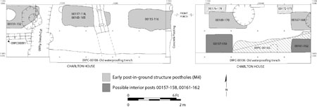 Figure 25. Plan of Early Post-In-Ground Structure postholes (M4).
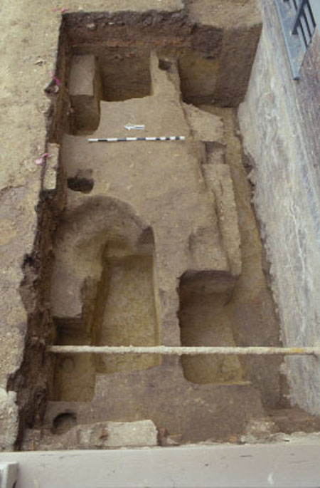 Figure 26. Photograph of Early Post-In-Ground Structure postholes to the east of the front porch.
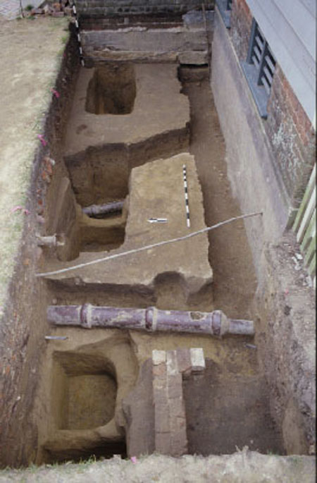 Figure 27. Photograph of Early Post-In-Ground Structure postholes to the west of the front porch.
conclude that the structure did not continue any further to the east, and its east gable end likely paralleled the eastern property boundary. Based on these conclusions, it is reasonable to estimate that the minimum length of the structure would have been at least 15.6 meters (51 feet) along Duke of Gloucester Street. The structure's width, however, still remains unknown.
Figure 27. Photograph of Early Post-In-Ground Structure postholes to the west of the front porch.
conclude that the structure did not continue any further to the east, and its east gable end likely paralleled the eastern property boundary. Based on these conclusions, it is reasonable to estimate that the minimum length of the structure would have been at least 15.6 meters (51 feet) along Duke of Gloucester Street. The structure's width, however, still remains unknown.
The original structural posts for the building cut through the postholes of the earlier fence line, as well as the early sheet refuse layer, thus post-dating both the fence and the layer. The excavation and interpretation of the structure's postholes was somewhat 48 complicated by the installation of a subsequent series of replacement posts into the building, as well as because of two mid-century planting features. Careful excavation of each posthole complex ultimately revealed the sequence of each replacement posthole overlapping each original posthole. The fact that the building stood long enough to warrant the replacement of its structural posts suggests that it had stood for a relatively long period of time. In general, wooden posts set into the ground would last approximately fifteen years before rotting and requiring replacement. Thus, a building whose posts have all been replaced may have stood as long as 30 years before it was ready to collapse.
The structure's original postholes were very large, rectangular in shape, with average dimensions measuring 73 x 64.2 cm (2.4 x 2.1 feet) in plan (Table 2). Each of the postholes was excavated to an average depth of 94 cm (3.08 feet), cutting through both the earlier fence line and refuse layer, and deep into the clay subsoil. The great depth of the structure's postholes is particularly remarkable when compared to other post-in-ground buildings in Williamsburg. Among them, the postholes of the Douglass Theatre, a large and probably multi-storied structure, measured on average only 64 x 57 x 53 cm (Lisa Fischer, personal communication). The Douglass Theater postholes were all smaller and not as deep as those on Lot 22. Based on the relatively large size and depth of the postholes on Lot 22 it is likely that the postholes were also intended to support a very substantial structure, possibly extending as tall as two stories or more above ground. In light of the comparison with the Douglass Theater posts, the structure on Lot 22 could have easily been just as large if not larger than the theater. Colonial Williamsburg architectural historian Willie Graham has further suggested that the large size of the postholes may have been to allow the walls of the structure to be raised as a unit, and to allow them to be jostled into place without the constraints of tight holes. It is unlikely that such jostling would be necessary with fence construction, thus further supporting the association of the postholes with a building rather than a fenceline (Willie Graham, personal communication).
No postmolds were found in association any of the original postholes, although they were clearly evident in the later replacement postholes. In addition, the fill within the original posthole, and the subsequent replacement posthole, was continuous across the two, suggesting that they were both filled at the same time. To account for the apparent absence of the original postmolds and the simultaneous filling of both the original and the replacement postholes, it is hypothesized that at the time the original posts were replaced, the original timbers were re-excavated and removed. In this scenario, once the replacement postholes were excavated, and new timbers were seated within the postholes to carry the load of the building, the original postholes were re-excavated and what remained of the original timbers was removed. After the removal of the original timber, both the original and replacement postholes was backfilled at the same time resulting in a continuous layer of fill across the two features.
Each of the repair postholes overlapped the eastern edge of each of its corresponding original posthole. The horizontal dimensions of the repair postholes were larger than the original posts, but were excavated to depths nearly equal to the originals (see Table 2). Each of the postmolds for the repair posts had flat bottoms and 49
| Posthole # (W-E) | Original Posthole Context | Length (E-W) | Width (N-S) | Depth | TPQ | Replacement Posthole Context | Length (E-W) | Width (N-S) | Depth | TPQ |
|---|---|---|---|---|---|---|---|---|---|---|
| 1 | 09PC-152,-153 | 70 | 60 | 85 | 1720 | 09PC-131,-132 | ** | 75 | 85 | NDA |
| 2 | 09PC-164,-165 | 74 | 50 | 96 | NDA | 09PC-117,-118 | 90 | 75 | 97 | 1730 |
| 3 | 09PC-155,-156 | ** | 69 | 97 | NDA | 09PC-115,-116 | 95 | 72 | 96 | 1720 |
| 4 | 09PC-169,-170 | 75 | 72 | 95 | 1720 | Unexcavated | ||||
| 5 | 09PC-167,-168 | ** | 70 | 97 | NDA | Unexcavated | ||||
| Average | 73 | 64.2 | 94 | 92.5 | 74 | 92.66 |
 Figure 28. Photograph of a posthole profile from the Early Post-In-Ground Structure.
Figure 29. S. Cobbs wine bottle seal.
measured between 20 and 25 cm (0.75 to 0.85 feet) in diameter while extending the full depth of the posthole.
In addition to the fact that the fill was continuous between each set of postholes (original and repair), the same vertical fill pattern was also observed between each set of postholes, with a minor variation in the thickness of each layer (Figure 28). In the bottom of each of the postholes, a thin lens of medium brown silt (Munsell color 7.5YR5/4) had accumulated. The silt was generally thickest within the bottom of the replacement post, possibly indicating that the postholes may have been left open longer while the original posts were being removed prior to the posthole's filling. Deposited over the silt lens was a 12-cm thick layer of brown sandy loam (Munsell color 7.5YR5/4) that contained a small quantity of early eighteenth-century artifacts. On top of that layer, a 35-cm thick layer of sterile orange sandy clay (Munsell color 2.5YR7/6) was deposited, which was followed by a 33-cm thick layer of heavily mottled light yellowish brown silty clay (Munsell color 7.5YR6/6), which also contained eighteenth-century artifacts. The most recent artifacts recovered from any of the postholes were fragments of dip-molded wine bottle glass (TPQ = 1730). In addition, among the many wine bottle glass fragments, an impressed wine bottle seal bearing the name "S. Cobbs" was recovered from the bottom of one of the postholes (Figure 29). The seal belonged to Samuel Cobbs, a tavern keeper and merchant who was in business in Williamsburg by 1719. By 1737, Cobbs moved from town to Amelia County,
51
Virginia, where he died in 1757. A similar seal bearing the name Cobbs was also found during Kirk and Noël Hume's investigations of the northwest corner of Lot 22 (William Pittman, personal communication). In summary, although the name of the individual who had the building constructed has not been recorded, the archaeological evidence suggests that it may have been built as early as 1730, which corresponds with William Byrd II's ownership of the property.
Figure 28. Photograph of a posthole profile from the Early Post-In-Ground Structure.
Figure 29. S. Cobbs wine bottle seal.
measured between 20 and 25 cm (0.75 to 0.85 feet) in diameter while extending the full depth of the posthole.
In addition to the fact that the fill was continuous between each set of postholes (original and repair), the same vertical fill pattern was also observed between each set of postholes, with a minor variation in the thickness of each layer (Figure 28). In the bottom of each of the postholes, a thin lens of medium brown silt (Munsell color 7.5YR5/4) had accumulated. The silt was generally thickest within the bottom of the replacement post, possibly indicating that the postholes may have been left open longer while the original posts were being removed prior to the posthole's filling. Deposited over the silt lens was a 12-cm thick layer of brown sandy loam (Munsell color 7.5YR5/4) that contained a small quantity of early eighteenth-century artifacts. On top of that layer, a 35-cm thick layer of sterile orange sandy clay (Munsell color 2.5YR7/6) was deposited, which was followed by a 33-cm thick layer of heavily mottled light yellowish brown silty clay (Munsell color 7.5YR6/6), which also contained eighteenth-century artifacts. The most recent artifacts recovered from any of the postholes were fragments of dip-molded wine bottle glass (TPQ = 1730). In addition, among the many wine bottle glass fragments, an impressed wine bottle seal bearing the name "S. Cobbs" was recovered from the bottom of one of the postholes (Figure 29). The seal belonged to Samuel Cobbs, a tavern keeper and merchant who was in business in Williamsburg by 1719. By 1737, Cobbs moved from town to Amelia County,
51
Virginia, where he died in 1757. A similar seal bearing the name Cobbs was also found during Kirk and Noël Hume's investigations of the northwest corner of Lot 22 (William Pittman, personal communication). In summary, although the name of the individual who had the building constructed has not been recorded, the archaeological evidence suggests that it may have been built as early as 1730, which corresponds with William Byrd II's ownership of the property.
To the south of the line of structural posts, within what would have been the interior of the building, indirect evidence suggests that the building had an earthen floor rather than a wooden floor. As the loose silt that had accumulated within the seventeenth-century drainage/irrigation ditch (M1) began to settle and compact, a linear depression formed at ground surface corresponding with the alignment of the ditch. In an effort to level the ground surface, and probably corresponding with the construction of the earthfast building, a dense layer of orange clay (09PC-166) was deposited within the depression, resulting in a compact flat surface. Unfortunately, however, no artifacts were recovered from the clay which could have helped to more accurately determine the date of its deposition. The fact that the depression was filled in suggests that the ground was exposed and was not hidden under a wooden floor. If the building did have a wooden floor, the depression would have been concealed and it seems unlikely that anyone would have bothered to fill in an unseen depression.
Additional evidence that the structure had an earthen floor was found across the surface of the early sheet refuse layer and to the south of each of the structural posts. Deposited over the early sheet refuse was a thin lens of orange clay and sand (09PC-171) that contained a small quantity of artifacts including tobacco pipe stems, wine bottle glass, and nails. None of which, however, had a meaningful TPQ date. The fact that the lens was restricted to only the south sides of each of the large structural posts, suggests that the posts formed a barrier preventing the accumulation/deposition of the lens to the north of the wall. Although only a very narrow portion of the lens remained intact, the lens may have represented the remnants of a floor surface within the building.
Additional features in association with the post-building included two large post features that were located only 1 meter (3.28 feet) south of the structure's north wall (see Figure 25) and may have been interior postholes for the building (09PC-157-158, -161-162). The western post was significantly truncated by twentieth-century disturbances which prevented its measurement, however, the eastern post was mostly intact. The feature was slightly larger than either the original or replacement posts of the structure, measuring 103 x 57 cm (3.38 x 1.87 feet), with an interval between the features measuring 3.2 meters (10.5 feet) on center from one another. Neither of the features had any evidence of a postmold, nor did the features exhibit any evidence of having been repaired or replaced. It remains possible that the features were postholes that had their posts excavated and removed, but not replaced. If they are interior postholes, their function, however, still remains a mystery. Among the possibilities is that the posts may have part of an internal partition within the building, or they were used as part of an internal support system upholding the structure, or they may have been part of a repair to the building. Similar interior postholes were also identified within a supposed tobacco barn at the King's Reach site in Calvert County, Maryland 52 (King 1999), which architectural historian Willie Graham has proposed may have been used to brace or support a tobacco press within the building (Willie Graham, personal communication). It remains an intriguing possibility that a similar press was used in Williamsburg.
Corresponding documentary evidence of a structure in the first half of the eighteenth century is not nearly as abundant as the archaeological evidence. Although James Shields, William Byrd II, and James Crosby are all identified as successive owners of the lot prior to 1750, there exists no clear mention of a structure on the property until 1749/50 when Crosby conveyed Lots 22, 23, and 24 to Alexander Archibald Buchanan and Company. In the conveyance, at least two structures are described as situated on the property including a warehouse and stable. Although the stable was more likely positioned on the back part of the lot, it is possible that the warehouse may have been located along the street. The earthfast structure found during the 2002 excavations might be the warehouse described in Crosby's deed. Unfortunately, no conclusive indication of the structures function was recovered to link the archaeological evidence to the documentary record. The archaeological data does however indicate that the construction of the building dates to after 1730 and that it had its vertical timbers replaced at least once, suggesting that the building stood for as long as 20 to 30 years, which corresponds very well with the documentary data that indicates that the structure was standing in 1749/50.
Shields, Byrd, and Crosby-Period Faunal Analysis
A small number of faunal remains were recovered from the early sheet refuse layer (M2); the early fenceline (M3); and the features associated with the earthfast structure (M4). Because of the small number of bones from each of these contexts, the animal bone was combined into a single macro-assemblage representing the 1707-1750 occupation of Lot 22. Even so, the pre-1750 faunal assemblage consisted of only 50 identifiable (28.9%) and 123 unidentifiable bones (70.1%), for a total of 173 bones (Table 3). From this relatively small assemblage of identifiable bone, only three different species were identified, all of which are domestic mammals: domestic cow (Bos taurus), domestic pig (Sus scrofa), and sheep/goat (Ovis aries/Capra hircus).4 The bones were undoubtedly the remains of meals consumed on or directly adjacent to the property, and were mostly likely purchased at a local market provisioned directly from the nearby countryside (Walsh et al. 1997:175).
Beef and veal elements were the most abundant from the assemblage, regardless of how they were quantified, with pig and sheep/goat elements recovered in substantially lesser quantities. Domestic cow was almost universally raised on plantations, although some urban-dwellers kept a cow or two on their lots to provide them with milk, butter, and cheese. Unlike pork, beef did not preserve well, and salt beef was never as important as salt pork (Price and Schweigert 1971; Bowen 1989). Thus it is likely that most of the beef eaten by urban-dwellers was purchased from farmers or at 53
| Weight | Biomass | |||||
|---|---|---|---|---|---|---|
| NISP | Pct. | (g) | Pct. | (kg) | Pct. | |
| Mammals | ||||||
| Class Mammalia (Mammal) | 51 | 29.5 | 25.9 | 3.8 | 0.492 | 4.6 |
| Class Mammalia I (Large Mammal) | 6 | 3.5 | 28.3 | 4.2 | 0.533 | 5.0 |
| Class Mammalia II (Medium Mammal) | 64 | 37.0 | 44.2 | 6.6 | 0.796 | 7.5 |
| Order Artiodactyla I (Sheep, Goat, Deer, or Pig) | 1 | 0.5 | 3.1 | 0.4 | 0.073 | 0.6 |
| Order Artiodactyla II (Sheep, Goat, Deer) | 1 | 0.5 | 4.2 | 0.6 | 0.096 | 0.9 |
| Sus scrofa (Domestic Pig) | 11 | 6.4 | 55.0 | 8.2 | 0.969 | 9.2 |
| Bos taurus (Domestic Cow) | 29 | 16.8 | 428.2 | 64.0 | 6.144 | 58.3 |
| Ovis aries/Capra hircus (Domestic Sheep or Goat) | 4 | 2.3 | 62.5 | 9.3 | 1.087 | 10.3 |
| Mammal | 173 | 100.0 | 668.6 | 100.0 | 10.530 | 100.0 |
| Total Identified | 50 | 28.9 | 562.9 | 84.2 | 19.070 | 81.1 |
| Total Unidentified | 123 | 70.1 | 105.7 | 15.8 | 1.990 | 18.9 |
| Grand Totals | 173 | 100.0 | 668.6 | 100.0 | 10.530 | 100.0 |
Domestic pigs were kept throughout the South and have over the years become almost a symbol of Southern foodways, although recent archaeological evidence suggests that beef was actually much more important (Bowen 1986). Pigs were kept principally on outlaying plantations and farms, and were easy to care for, requiring little watchfulness and an unspecialized diet (Reitz 1979). Because pigs would yield 65-80% of their weight as dressed meat, as apposed to 50-60% for cattle and 45-55% for sheep, raising them was a profitable commercial enterprise (Reitz 1979:78). Virtually all plantation owners kept hogs, and virtually every part of the slaughtered animal was eventually utilized. The animals were typically killed during the late fall or winter, and excess meat was ordinarily smoked, salted, pickled, or potted.
Sheep or goats accounted for the remainder of the assemblage. Sheep were commonly raised on eighteenth-century plantations and farms, although they never became really profitable since they were unable to defend themselves from predators and would not freely reproduce (Gray 1958; Reitz 1979). Goats were occasionally raised, although primarily for their milk rather than their meat (Noël Hume 1978:20). Neither sheep nor goat was a primary food source, and their importance pales in comparison with pigs and cattle.
Unfortunately, the small number of identifiable bones is too small to provide reliable information on the relative dietary importance of the animals represented in the 54 assemblage. In general, however, the assemblage data is consistent with other pre-1750 faunal assemblages from Williamsburg, which consistently demonstrate that large domestic mammals were more important food resources than fish, fowl or wild animals.
Alexander Archibald Buchanan and Company and John Carter-Period Features
Beginning at mid-century, and possibly precipitated by the recent change in ownership of the property, significant changes were wrought upon the development of Lot 22. Probably shortly after James Crosby's sale of Lot 22, the earthfast warehouse was torn down or allowed to fall down. After an initial period when the lot was probably vacant, archaeological evidence of the construction of a small store or workshop located in the northwest corner of the lot was recovered. The building's construction reflected the emergence of the east end of Duke of Gloucester Street as an important commercial center within the city.
Mid-Eighteenth-Century Sheet Refuse Layer (M5)
Directly overlaying the postholes of the early post-in-ground building was a layer of sheet refuse. The fact that the sheet refuse collected over the posthole features indicates that the layer post-dates the construction of the structure. The layer consisted of an 8 to 10 cm (0.33 feet) stratum of mottled brown (Munsell 2.5Y4/3) silty clay loam, and contained a relatively dense concentration of mid-eighteenth-century artifacts (n=2189) that included a variety of ceramics, glass, animal bone, personal items, and architectural debris (Table 4).
Ceramic fragments accounted for 16.7% of the total artifact assemblage (Figure 30). Among the ceramics, delftware and red sandy coarse earthenware accounted for the largest percentage of the ceramic fragments. In addition, fragments of Border ware, North Midland slipware, Buckley ware, North Devon gravel tempered, Yorktown, and Derbyshire coarse earthenwares were all also recovered from the refuse layer. Imported stonewares accounted the most of the remainder of the ceramics and included fragments of white salt-glazed stoneware, Fulham, Westerwald, and Nottingham. A small quantity of Chinese porcelain was also recovered, in addition to a very small number of refined earthenwares, which consisted of only a single fragment of Jackfield, a single fragment of Whieldon, and a single fragment of creamware. The recovery of the creamware, typically not found in Williamsburg until after 1762, is inconsistent with the rest of the ceramics recovered from the layer, which are all typically representative of early to mid-eighteenth-century assemblages. Thus it is possible that the lone creamware fragment is a later intrusion into the layer.
Domestic glass from the layer, which included fragments of wine bottle glass, pharmaceutical glass, container glass, case bottle glass, and table glass, accounted for 30.8% of the total assemblage, the majority of which was wine bottle glass. Architectural debris consisting of nails, window glass, and roofing slate accounted for 21.2% of the layer, while tobacco pipes accounted for 8.2% of the layer. Several of the tobacco pipes had maker's marks with a letter "F" on the left side of the base, and a 55
| Number | Percent | |
|---|---|---|
| Tin Glazed | ||
| Delftware | 129 | 5.9 |
| Coarsewares | ||
| Border | 2 | 0.1 |
| North Midlands Slip | 4 | 0.2 |
| Buckley | 1 | 0.1 |
| North Devon | 3 | 0.1 |
| Red Sandy | 116 | 5.3 |
| Yorktown | 19 | 0.9 |
| Derbyshire | 1 | 0.1 |
| Stonewares | ||
| White Salt Glazed (dipped) | 23 | 1.1 |
| White Ssalt Glazed | 5 | 0.2 |
| Fulham | 16 | 0.7 |
| Westerwald | 10 | 0.5 |
| Nottingham | 20 | 0.9 |
| Other | 1 | 0.1 |
| Refined Earthenwares | ||
| Creamware | 1 | 0.1 |
| Whieldon | 1 | 0.1 |
| Jackfield | 1 | 0.1 |
| Porcelain | ||
| Chinese | 10 | 0.5 |
| Refractory Clay | 2 | 0.1 |
| Glass | ||
| Wine Bottle | 508 | 23.2 |
| Pharmaceutical | 3 | 0.1 |
| Container | 61 | 2.8 |
| Table | 30 | 1.4 |
| Case Bottle | 73 | 3.3 |
| Tobacco Pipes | 180 | 8.2 |
| Architectural | ||
| Nails | 314 | 14.3 |
| Window Glass | 148 | 6.8 |
| Slate | 1 | 0.1 |
| Faunal | 450 | 20.6 |
| Oyster Shell | 28 | 1.3 |
| Other | 28 | 1.3 |
| Total | 2189 | 100.0 |
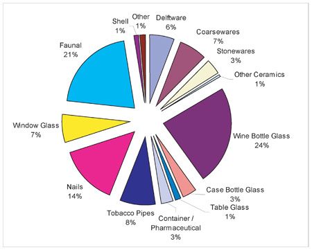 Figure 30. Artifacts from the mid-eighteenth-century sheet refuse layer (M5).
letter "S" on the right side, with a crown surmounting each letter. Unfortunately, that particular mark remains unattributed to a specific pipemaker. Pipes with a second variety of maker's mark was also recovered. The mark consisted of the letter "W" on the left side of the base, and the "M" on the right. The mark most likely represents the mark of one of several different William Manbys, all of whom belonged to the same family of London pipemakers who produced pipes from 1681 to 1770 (Oswald 1975:142). Faunal remains accounted for 20.5% of the sheet refuse layer and comprised the remainder of the recovered material.
Figure 30. Artifacts from the mid-eighteenth-century sheet refuse layer (M5).
letter "S" on the right side, with a crown surmounting each letter. Unfortunately, that particular mark remains unattributed to a specific pipemaker. Pipes with a second variety of maker's mark was also recovered. The mark consisted of the letter "W" on the left side of the base, and the "M" on the right. The mark most likely represents the mark of one of several different William Manbys, all of whom belonged to the same family of London pipemakers who produced pipes from 1681 to 1770 (Oswald 1975:142). Faunal remains accounted for 20.5% of the sheet refuse layer and comprised the remainder of the recovered material.
Determining the age of the layer was established by means of several different complementary techniques, including the above referenced dates from the tobacco pipe maker's marks. The TPQ of the layer was determined to be 1762 based on the single fragment of creamware. This date, however, is questionable due to speculation that the single creamware fragment was intrusive into the layer. The next most recent artifact was a single fragment of Derbyshire coarse earthenware that has a TPQ of 1750, which may be a more realistic date for the accumulation of the layer, as the rest of the artifacts all have much earlier manufacturing dates that consistently date to the late seventeenth and early eighteenth centuries. Following the techniques pioneered by J.C. Harrington (1954) and Lewis Binford (1962), the imported tobacco pipe stems with measurable stem bore diameters were used as an additional method of determining possible deposition date for the refuse layer. The sample consisted 111 pipe stems, which were measured using a set of graduated drill bits that ranged in size from 6/64 inches to 4/64 inches. Interestingly, pipe stems with bore diameters measuring 5/64 inches 57 and 4/64 inches were equal in number, followed by a small number of stems measuring 6/64 inches (Figure 31).
In general, both Harrington and Binford's techniques are based on the premise that through time, pipe stem bore diameters decreased in size. Harrington developed a histogram assembling different sized pipe stem bore diameters into temporal groupings (Figure 32). Using Harrington's method, the distribution of measurable pipe stems from the sheet refuse layer does not match any single time period. Instead the distribution appears to span almost the entire eighteenth century, 1710-1800. Although it is unlikely that the sheet refuse was continually accumulating for an entire century, the flat distribution does suggest that accumulation of the layer centered around 1750. Alternatively, Lewis Binford developed a straight-line regression formula using the measured diameters of pipe stems to determine a mean date for a particular sample of pipe stems. By applying Binford's formula to the pipe stem sample from the sheet refuse layer, the calculated mean date is 1758.13, which approximately correlates with the Harrington date.
Although the dates are variable, by considering all the different dating techniques together, it may be possible to determine a reasonable estimate of the layer's accumulation. Initially, the TPQ for the layer was determined as 1762, based on the recovery of a single fragment of creamware. The late date of the artifact in comparison to the dates of all other artifacts from the layer, however, suggests that it may be an intrusion, and thus would be misrepresentative of the layer's accumulation. The next most recent TPQ is 1750, based on a fragment of Derbyshire coarse earthenware, a date which is more characteristic of the rest of the assemblage. Similarly, Harrington's pipestem histogram technique also indicates a circa 1750 date for the accumulation of the layer, and Binford's formula produces a mean date of 1758. Although varying slightly, each of the dating estimates places the layer's age at, or shortly after, mid-century.
Planting Features
Two large and deep planting features, both of which date to mid-century, were also found along the northern boundary of Lot 22 (Figure 33). The eastern planting feature
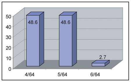 Figure 31. Pipestems from mid-eighteenth-century sheet refuse layer (M5).
58
Figure 31. Pipestems from mid-eighteenth-century sheet refuse layer (M5).
58
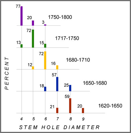 Figure 32. Harrington histogram (from Harrington 1954).
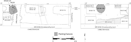 Figure 33. Plan of planting features.
(09PC-120-121) measured 75 x 85 cm (2.46 x 2.79 feet) across the top, although a twentieth-century utility pipe had disturbed much of this feature. The depth of the feature measured 115 cm (3.77 feet), and cut through the mid-eighteenth-century sheet refuse layer (M5) and a posthole (09PC-131-132, -152) from the earlier post-in-ground structure. The substantial width and the depth of the planting hole indicate that it held a fairly large plant at one time, possibly a small tree or large bush. The fact that the planting feature was aligned along the same orientation as the earlier posthole features, and the fact that the planting feature intruded a posthole made it very difficult for the excavators to discern the planting feature's fill from the posthole fill. A relatively high number of artifacts (n=186) were recovered from the planting feature fill,
59
although their recovery was not particularly surprising given the fact that the feature cut through the artifact-rich layer of mid-eighteenth-century refuse. Similar to the refuse layer, a TPQ of 1730 was attributed the planting feature based on the recovery of dip-molded wine bottle glass, although the feature clearly post-dates the accumulation of the sheet refuse which has been attributed to circa 1750.
Figure 33. Plan of planting features.
(09PC-120-121) measured 75 x 85 cm (2.46 x 2.79 feet) across the top, although a twentieth-century utility pipe had disturbed much of this feature. The depth of the feature measured 115 cm (3.77 feet), and cut through the mid-eighteenth-century sheet refuse layer (M5) and a posthole (09PC-131-132, -152) from the earlier post-in-ground structure. The substantial width and the depth of the planting hole indicate that it held a fairly large plant at one time, possibly a small tree or large bush. The fact that the planting feature was aligned along the same orientation as the earlier posthole features, and the fact that the planting feature intruded a posthole made it very difficult for the excavators to discern the planting feature's fill from the posthole fill. A relatively high number of artifacts (n=186) were recovered from the planting feature fill,
59
although their recovery was not particularly surprising given the fact that the feature cut through the artifact-rich layer of mid-eighteenth-century refuse. Similar to the refuse layer, a TPQ of 1730 was attributed the planting feature based on the recovery of dip-molded wine bottle glass, although the feature clearly post-dates the accumulation of the sheet refuse which has been attributed to circa 1750.
The western planting feature (09PC-148-149) also cut through the mid-eighteenth-century sheet refuse layer (M5), as well as another one of the earthfast structure's postholes (09PC-169-170). The feature measured 105 x 90 cm (3.44 x 2.95 feet) across its top and had tapered sides sloping to the middle. The depth of the feature measured 96 cm (3.15 feet) deep. Similar to the eastern planting feature, a relatively high number (n=184) of artifacts were recovered from the planting fill. The TPQ for the feature was also 1730 based on fragments of dip-molded wine bottle glass. However, once again, the planting feature clearly post-dated the mid-century layer of the sheet refuse.
Alexander Archibald Buchanan & Company and John Carter-Period Faunal Analysis
Once again, several different contemporary contexts were combined into a single macro-assemblage for the purposes of the faunal analysis. In this instance, the faunal remains recovered from the three planting features were combined with contemporary with the sheet refuse layer into a single macro-assemblage that accumulated between 1750 and 1769. The assemblage consisted of a total of 492 bones, of which only 63 were identifiable (12.8%), leaving 429 as unidentified (87.2%).
Domestic mammals-cow (Bos taurus), pig (Sus scrofa), and sheep/goat (Ovis aries/Capra hircus)-accounted for all the identified mammals, and once again for the majority of the total assemblage (Table 5). Their relative abundance, once again, reflects the increasing reliance of Williamsburg's residents upon domestic animals for food. As previously mentioned, the meat from these animals was likely purchased at a local market, rather than raising and butchering the animals on site (Walsh et al. 1997:175).
In addition to the large number mammal bones, nearly two dozen bird bones were also recovered. Unfortunately, however, only two were identifiable to species, both of which were chicken (Gallus gallus). According to diaries and traveler's accounts, chicken was, with beef and pork, among the most common meats of the colonial and post-colonial period. Almost every household, even in towns and cities, probably kept at least a few chickens (Noël Hume 1978:22), since they were easy to keep and furnished eggs as well as meat.
Fish bones rounded out the assemblage, including two different species of fish: sheepshead (Archosargus probatocephalus) and black drum (Pogonias cromis). Only a single sheepshead element was recovered. Sheepshead were abundant in the colonial Chesapeake, and were often mentioned in descriptions of the area (Murdy et al. 1997). Sheepshead can be found in the lower Chesapeake during the summer, and typically congregate near jetties, wharves, pilings, and shipwrecks. A single bone from a black drum was also recovered. Black drum are large ocean-going fish, an average 60
| Weight | Biomass | |||||
|---|---|---|---|---|---|---|
| NISP | Pct. | (g) | Pct. | (kg) | Pct. | |
| Fish | ||||||
| Class Osteichthyes (Bony Fish) | 5 | 1.0 | 0.4 | 0.0 | 0.014 | 0.0 |
| Archosargus probatocephalus (Sheepshead) | 1 | 0.2 | 1.0 | 0.0 | 0.030 | 0.1 |
| Pogonias cromis (Black Drum) | 1 | 0.2 | 5.8 | 0.4 | 0.118 | 0.5 |
| Birds | ||||||
| Class Aves (Bird) | 17 | 3.4 | 5.7 | 0.4 | 0.100 | 0.4 |
| Class Aves/Mammalia III (Bird/Small Mammal) | 4 | 0.8 | 0.6 | 0.0 | 0.013 | 0.0 |
| Gallus gallus (Chicken) | 2 | 0.4 | 5.3 | 0.3 | 0.093 | 0.4 |
| Mammals | ||||||
| Class Mammalia (Mammal) | 167 | 33.9 | 51.8 | 3.7 | 0.918 | 4.3 |
| Class Mammalia I (Large Mammal) | 127 | 25.8 | 634.7 | 26.2 | 5.318 | 25.3 |
| Class Mammalia II (Medium Mammal) | 106 | 21.5 | 109.5 | 7.8 | 1.801 | 8.5 |
| Class Mammalia III (Small Mammal) | 1 | 0.2 | 0.0 | 0.0 | 0.002 | 0.0 |
| Order Artiodactyla I (Sheep, Goat, Deer, or Pig) | 2 | 0.4 | 4.8 | 0.0 | 0.108 | 0.5 |
| Sus scrofa (Domestic Pig) | 12 | 2.4 | 51.1 | 3.6 | 0.907 | 4.3 |
| Bos taurus (Domestic Cow) | 21 | 4.2 | 547.9 | 39.4 | 7.671 | 36.5 |
| Bos taurus (Domestic Cow/Calf) | 13 | 2.6 | 124.0 | 8.9 | 2.014 | 9.5 |
| Ovis aries/Capra hircus (Domestic Sheep or Goat) | 13 | 2.6 | 116.6 | 8.3 | 1.906 | 9.0 |
| Fish | 7 | 1.4 | 7.2 | 0.4 | 0.162 | 0.6 |
| Bird | 23 | 4.6 | 11.6 | 0.7 | 0.206 | 0.8 |
| Mammal | 462 | 93.6 | 1640.4 | 97.9 | 20.645 | 97.9 |
| Total Identified | 63 | 12.8 | 851.7 | 61.3 | 12.739 | 60.6 |
| Total Unidentified | 429 | 86.4 | 537.5 | 38.7 | 8.274 | 39.4 |
| Grand Totals | 492 | 100.0 | 1389.2 | 100.0 | 21.013 | 100.0 |
Early Brick Foundation
During the 1966 excavations of Lot 22 the heavily disturbed remnants of a narrow brick foundation were identified in the northwest corner of the lot.5 At the time, only portions of the west and south brick foundation walls of the structure were found, 61 while the north and east walls were assumed to been eradicated by the construction of a later building built on the same location. Artifacts from the foundation's builder's trench, and an accompanying debris layer, suggested a construction date in the second quarter of the eighteenth century (Kirk 1967:14-16). Unexpectedly, during the waterproofing excavations of the Charlton House in 2002, a previously undiscovered portion of the same early brick foundation was unearthed (Figure 34), consisting of the northeast corner of the structure's brick foundation (09PC-91). The northeast corner of the foundation had escaped notice in 1966, because it was preserved under a baulk left in place around a tree that had stood at the northwest corner of the Charlton House in 1966. At the time, it was taken for granted that nothing of the foundation remained under the tree. The tree has since been removed, thus allowing for the archaeological investigation of the area, which ultimately resulted in the discovery of the foundation.
All that remained intact of the foundation was the bottom course of bricks. Evidently, the planting hole for the tree, which had prevented the exposure of the foundation in 1966, displaced the upper courses of the foundation and all the overlaying strata. The north wall was two bricks wide, with the bricks laid as stretchers lengthwise in the wall (Figure 35). The foundation's east wall was one brick length thick with the bricks laid as headers along the wall. A shell-based mortar, typical of eighteenth-century masonry, was used to bond the bricks together. The sizes of the bricks measured on average 77 8 x 4 x 2 inches (20 x 10 x 5 cm). In comparison, the bricks from the structure's east and original south wall measured 73 8 x 3½ x 2 inches (18.75 x 9 x 5 cm) and 7¼ x 3½ x 1 7/8 inches (18.5 x 9 x 4.75 cm) (Kirk 1967:49).
In 1966 the exterior dimensions of the structure were estimated at 6.35 m (20'10") deep (north-south) and at least 4.65 m (15'3") wide (east-west) with a 3.05 m (10') shed addition to the rear. These measurements were based on the assumption that the location of the building's north wall corresponded with the north wall of a later building on the same location, and that the structure's east wall was destroyed by the construction of the present Charlton House. However, with the identification of the building's northeast corner a more precise measurement of the building's dimensions can now be determined. The corner of the foundation was not found in line with the north wall of the later building as previously assumed, but instead excavators discovered an addition 90 cm (3 feet) further to the north. Nor had the construction of the Charlton House completely destroyed the east wall, instead the wall stood 72 cm (2.4 feet) to the west of the Charlton House. In light of this new evidence, the revised dimensions of the first period structure measured 7.16 m (23'6") deep (north-south), and 4.95 m (16'3") wide (east-west), plus the 3.05 m (10.0') shed addition to the rear.
The archaeological evidence from 2002 also suggests a slightly later construction date for the building than had previously been concluded. In 1966, the date of the building's construction had been estimated at 1740. However, during the 2002 excavations, the evidence of the structure's northeast corner was clearly built over the mid-eighteenth-century sheet refuse layer (M5), which has been dated to circa 1750, thus dating the construction of the building after 1750. Unfortunately, no evidence of the structure's builder's trench was found in order to more specifically determine the building's age.
62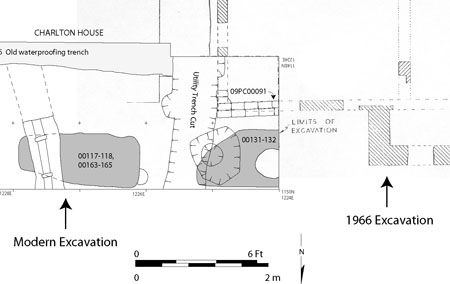 Figure 34. Plan of Early Brick Foundation.
 Figure 35. Photograph of northeast corner of the Early Brick Foundation.
Neither the 1966 nor the 2002 excavations recovered any evidence to indicate the function of the building. Similarly, there exists no documentary evidence to suggest what purpose this structure may have served. However, the small size of the building and its prominent location along Duke of Gloucester Street, both suggests that the building was probably used a small shop occupied by either a merchant or crafts/trades person. The small structure stood only for a short while, as it was replaced with a new building on the same location in the late 1760s.
Charlton House Features
Edward Charlton, a local wigmaker, probably purchased Lot 22 in the late 1760s, at which time, or possibly right before its purchase, the present-day Charlton House was constructed. It is unknown if Charlton financed the construction of the house, or if a house was already standing when he purchased the property. Edward Charlton eventually deeded the property to the estate of Richard Charlton, whose widow and children lived on the property from 1784 until 1795. Unfortunately, the archaeological evidence of the house's construction was minimal. The best preserved archaeological evidence relating to Edward and Jane Charlton's occupation included the remnants of a brick-paved sidewalk. The stratigraphic position of the sidewalk suggests that shortly after the construction of the house, the sidewalk was laid across the north end of the lot and parallel to Duke of Gloucester Street. The sidewalk would have provided a more hospitable path for pedestrians away from traffic in the street and within closer proximity of the shops.
Charlton House Construction Features
In spite of the thorough excavations around three sides of the Charlton House in 2002, the archaeological evidence of its construction was minimal, primarily due to the extensive redesign of the rear of the house in the nineteenth century which destroyed all traces of the original portions of the house's southern elevation. Similarly, the restoration of the house in 1929-30, and a later attempt to waterproof the house's foundation, combined to obliterate nearly all evidence of construction-related features around the north and west elevations of the house. Consequently, the surviving evidence pertaining to the construction of the Charlton House is limited to a thin lens of mottled clay construction debris (09PC-145), and a heavily disturbed portion of its builder's trench (09PC-138-139). The only additional physical evidence regarding the construction of the house was a variation in the brickwork of the basement walls noted during a previous architectural evaluation that identified three distinct phases of construction for the house's basement. As a result of this lack of evidence, our ability to expand upon the existing documentary and architectural inferences was significantly hampered by the scarcity of intact archaeological evidence.
Both the lens of construction debris, and the builder's trench, were located along the north elevation of the house and to the east of the reconstructed front porch. The construction debris measured only 3 cm thick and consisted of yellowish brown clay (10YR5/4) mottled with pockets of dark brown clay (10YR3/3). Although thin, the layer contained artifacts (n=199) and numerous brick fragments (Table 6). A TPQ of 1740 for the layer was determined based on the recovery of fragments of molded white salt glazed stoneware and Whieldon-type refined earthenwares, although the stratigraphic position of the layer indicates that the layer post-dates the circa 1750 sheet refuse layer and planting features.
The second construction related feature was a heavily disturbed section of builder's trench (09PC-138-139) along the eastern end of the Charlton House's north elevation. Previous waterproofing of the house's foundations displaced the portion of the builder's trench directly against the house, leaving only a narrow remnant of the feature 64
| Construction Debris Lens | Builder's Trench | Total | Percent | |
|---|---|---|---|---|
| Tin Glazed | ||||
| Delftware | - | 2 | 2 | 0.5 |
| Coarsewares | ||||
| Red Sandy | 1 | 3 | 4 | 1.0 |
| Stonewares | ||||
| White Salt Glazed | - | 1 | 1 | 0.3 |
| Fulham | - | 1 | 1 | 0.3 |
| Other | 1 | - | 1 | 0.3 |
| Refined Earthenwares | ||||
| Whieldon | 1 | - | 1 | 0.3 |
| Porcelain | ||||
| Chinese | - | 2 | 2 | 0.5 |
| Refractory Clay | - | - | - | - |
| Glass | - | - | - | - |
| Wine Bottle | 18 | 9 | 27 | 7.1 |
| Pharmaceutical | 1 | 1 | 0.3 | |
| Container | 1 | 11 | 12 | 3.2 |
| Tobacco Pipes | 5 | 3 | 8 | 2.1 |
| Architectural | ||||
| Nails | 23 | 23 | 46 | 12.1 |
| Window Glass | 73 | 84 | 157 | 41.4 |
| Slate | - | - | - | - |
| Faunal | 51 | 49 | 100 | 26.4 |
| Oyster Shell | 3 | 4 | 7 | 1.9 |
| Other | 3 | 6 | 9 | 2.4 |
| Total | 180 | 199 | 379 | 100.0 |
As indicated above, however, no intact archaeological features were found corresponding with either the first phase of brickwork at the west end of the north elevation, or the second phase along the rear of the house. As a result, no comparison of construction-related features from the different phases of the Charlton House's construction was possible.
The layer of construction debris, as well as the supposed builder's trench, contained artifacts and brick fragments. Particularly remarkable about the artifacts from each of these features was the high frequency of architectural debris recovered in proportion to the frequency of domestic refuse. Architectural debris from both features, consisting of nails and window glass, accounted for over fifty percent of all the artifacts recovered from each feature, while non-architectural debris such as ceramics, glass, and faunal remains, typically associated with domestic refuse, accounted for most of the remainder of each feature's artifact total. In comparison, the two earlier layers of sheet refuse overwhelmingly consisted primarily of household refuse, with only a minimal quantity of architectural debris (Figure 36). The dramatic increase in frequency of architectural debris versus domestic debris between the construction-related features and the earlier occupation layers likely reflects the activities that took place on the site while the features were forming and the layers accumulating. Logically, architectural debris most likely would have accumulated primarily during periods of construction and renovation, while domestic artifacts most likely would have accumulated as the result of the disposal of household refuse during an earlier occupation of the property. Accordingly, the accumulation of the layer of construction debris and the filling of the possible builder's trench feature, both of which contain high proportions of architecturally related material, likely correspond with the construction of the Charlton House.
Analysis of artifacts from the two construction-related features, and their relative stratigraphic positions, indicates a construction date somewhat earlier than suggested by the documentary research. Although all artifacts from the features are typical of
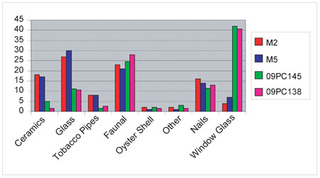 Figure 36. Comparison of artifacts from the Charlton House construction-related features and the sheet refuse layers.
66
those recovered from pre-1750 contexts, both features overlay the circa 1750 layer of sheet refuse. Consequently, the construction of the Charlton House must also post-date the layer of sheet refuse. How much after 1750, however, is unclear. While the earliest documentary evidence of the existence of the Charlton House is from 1769, the archaeological evidence suggests a construction date as early as the mid-1750s. Most likely, the construction of the house probably occurred sometime between the two dates, probably sometime during the 1760s, possibly coinciding with Edward Charlton's purchase of the property.
Figure 36. Comparison of artifacts from the Charlton House construction-related features and the sheet refuse layers.
66
those recovered from pre-1750 contexts, both features overlay the circa 1750 layer of sheet refuse. Consequently, the construction of the Charlton House must also post-date the layer of sheet refuse. How much after 1750, however, is unclear. While the earliest documentary evidence of the existence of the Charlton House is from 1769, the archaeological evidence suggests a construction date as early as the mid-1750s. Most likely, the construction of the house probably occurred sometime between the two dates, probably sometime during the 1760s, possibly coinciding with Edward Charlton's purchase of the property.
Brick Sidewalk
Shortly after the construction of the Charlton House, improvements to the approach to the building were made. In particular, a brick-paved sidewalk (M7) stretched across the north end of Lot 22, in front of the Charlton House and the adjacent wigmaking/tailor shop. The addition of a sidewalk represented a significant alteration and improvement to the lot, making the ground surface cleaner and less treacherous for pedestrians and potential shoppers walking past the lot or into the area's many shops and businesses.
The sidewalk bricks were seated on a bed of ash and sand (M8) spread across the north end of Lot 22 in front of the house and shop. The layer consisted of overlapping lenses of dark gray ash (7.5YR4/1) and olive yellow sand (2.5Y6/6) that were deposited directly over the construction-related features of the Charlton House. The lack of any intervening stratigraphy suggests that the sidewalk was installed shortly after the construction of the house was completed. The bed of ash and sand was likely deposited in order to provide an even surface to lay the paving bricks for the sidewalk onto. Among the numerous artifacts recovered from the layer were several fragments of creamware (TPQ = 1762), indicating the sidewalk was not laid down until after 1762, a date that is consistent with the evidence of the Charlton House's construction, although a more precise date may be ca. 1770 which takes into account the relevant historical data.
The best-preserved portion of the sidewalk was found to the east of the reconstructed front porch (Figure 37), and continued to the north and east beyond the boundaries of the archaeological trenches. No evidence of mortar adhering to any of the bricks was found, indicating that the bricks were dry-laid directly on the bed of ash and sand. The bricks within the sidewalk were laid in no discernible pattern and consisted entirely of either half or three-quarter brickbats. No whole bricks were found to have been used anywhere within the sidewalk. Unfortunately, to the west of the porch, nothing more than a layer of jumbled and crushed brick remained of the original sidewalk. The brick rubble also extended to the north and west beyond the excavation trenches.
Charlton Period Occupation Layers
The eighteenth-century occupation of the Charlton House was evidenced by three distinct layers of artifact-rich sheet refuse recovered from along the north elevation of the house (Figure 38). The accumulation of the layers likely resulted from the disposal
67
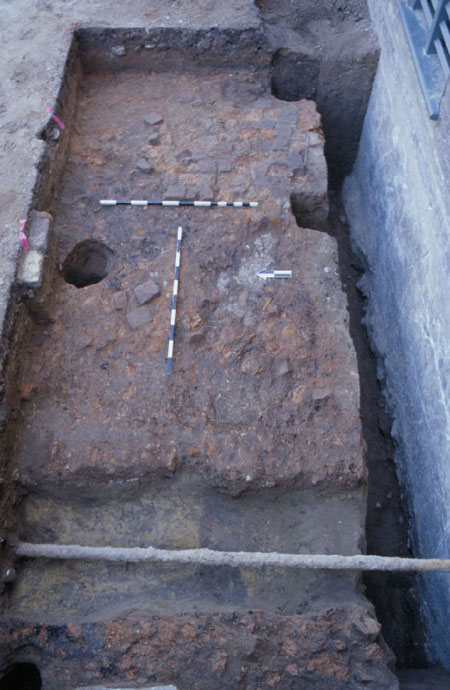 Figure 37. Photograph of the intact brick sidewalk to the east of the reconstructed front porch.
 Figure 38. Sheet refuse layers to the north of the Charlton House.
68
of household refuse and debris. As the everyday trash was being removed from the house, it was being taken out either the front or back door of the house and was dumped into the yard or street. However, as previously discussed, extensive twentieth-century disturbance to the rear of the house destroyed any evidence of the eighteenth-century sheet refuse there, leaving only the sheet refuse layers which accumulated in front of the house.
Figure 38. Sheet refuse layers to the north of the Charlton House.
68
of household refuse and debris. As the everyday trash was being removed from the house, it was being taken out either the front or back door of the house and was dumped into the yard or street. However, as previously discussed, extensive twentieth-century disturbance to the rear of the house destroyed any evidence of the eighteenth-century sheet refuse there, leaving only the sheet refuse layers which accumulated in front of the house.
The recovery of the sheet refuse layers from either side of the front porch suggests that there was no significant preference to which side of the porch the refuse was being deposited. Artifacts from each of the layers had TPQ's of no later than 1783, thus linking their accumulation with the occupation of house by the Charlton family-first by Edward and Jane Charlton, and followed by Richard Charlton's widow, Sarah, and her children.
The first layer consisted of a stratum of olive gray (2.5Y4/2) sand (09PC-130) that sealed the remains of the brick sidewalk. The fact that the sidewalk post-dated 1762 indicates that the accumulation of the sheet refuse had to come after 1762 as well. The layer measured only 5 to 8 cm thick and contained a large quantity of eighteenth-century artifacts (n=1047). Deposited directly over the sand was a 1 to 10 cm thick lens of dark yellowish brown (10YR4/6) sand, ash and burned material (09PC-128), which contained large chunks of charcoal, as well as a variety of eighteenth-century artifacts (n=124). The presence of the charcoal and ash suggests that the layer may have been formed partially as a result of the cleaning out of one of the large fireplaces within the Charlton House. The fact that none of the artifacts from the layer showed any evidence of having been burned further suggests that the ash and charcoal probably came from a contained fire, such as a fireplace or stove, rather than from a house fire which would have resulted in the burning of other materials in addition to wood. The third layer of debris was a very thin (<1 cm) lens of crushed brick (09PC-125). The layer included a small number of eighteenth-century artifacts (n=79), but unlike the first and second layers, the lens was found only to the east of the front porch.
Sealing the three layers of sheet refuse was a densely compacted clay cap (M9) that spread across the front of the entire north elevation of the Charlton House. Although the installation of a twentieth-century sewer line partially disturbed the western extent of the clay cap, there was no evidence that the clay extended beyond the northwest corner of the house. In other words, the clay was limited to only in front of the Charlton House, and was not present in front of the neighboring shop located on the northwest corner of the lot. To the east, the clay layer extended beyond the limits of the archaeological trench, leaving the eastern extent of the clay undetermined. The clay was yellowish brown (10YR5/8) in color, and varied in thickness from 2 to 40 cm, with the thickest section along the west side of the front porch, and drastically tapering to the west. Meanwhile, to the east of the front porch, the clay cap remained a consistent 20 cm thick. A total of 788 artifacts were recovered from the clay, consisting of a variety of eighteenth-century ceramics, glass, tobacco pipes, animal bone, and architectural debris. Although the TPQ for the layer was only 1720, the fact that clay was deposited over several third-quarter eighteenth-century contexts indicates 69 that the clay was also probably deposited either in the third or forth quarter of the eighteenth century.
Unlike the thin layers of sheet refuse found underneath the clay that had accumulated slowly over time, the dense homogenous nature of the clay cap indicates that the clay was probably deposited in a single short event. The deposition of the clay across the front of the house may have been an attempt to modify the landscape in front of the house. Although a brick sidewalk had previously stretched across the front of the house, it was evidently no longer in use as household debris, and debris from the street had been allowed to accumulate over the brick paving, which was covered by the clay cap. Accordingly, several possible hypotheses for why the clay cap was deposited are considered. The least likely scenario is that the clay may have been laid down to cover the unsightly mess of the ground surface around the house. It is unlikely that the residents of the house would have expended the time, energy and money to cover over the debris. If the accumulation of the debris was truly a problem for the residents, a simple sweeping would have sufficed to improve the appearance of the yard in front of the house. A more likely scenario is that the clay was deposited in order to build up the ground surface around the house. From a strictly utilitarian perspective, the clay may have been added for drainage purposes. By sloping the clay away from the house the goal may have been to drain or direct the water dripping off the roof of the house away from the building, rather than to allow it to pool around it the foundations, which over time would seep into the basement. An intriguing third alternative explanation is that the owners/occupants of the house were deliberately building up the ground surface around the house in order to give the appearance that the house had been built atop a small hill or knoll. When originally constructed, the Charlton House was built at the same elevation as the street and neighboring structures. However, by adding the clay along the front of the house, the illusion that the house was constructed atop of a small hill would be achieved, possibly serving as a symbolic metaphor for the elevated status of the house's occupants, or their own perceptions of what their status was among their neighbors. The symbolic expression of status through landscape manipulation was not uncommon in the eighteenth century, nor is it today. The use of vistas, formal gardens, and exotic plants, among other features, were commonly used among the eighteenth-century elite to express or convey their status (Yentsch 1994:113-129). As a wigmaker, Edward Charlton was not among Williamsburg's wealthy elite; however, as a skilled and successful craftsman, Charlton might have believed that they had realized a level of social and economic success beyond the achievements of his neighbors. It is interesting to consider the possibility that Charlton deliberately attempted to convey his elevated status by cosmetically altering the appearance of his property with features commonly associated with the homes of Williamsburg's rich and powerful.
Charlton Period Artifacts and Faunal Analysis
In addition to Edward Charlton's income from his wigmaking business, the family was no doubt further financially supported with income from Jane Charlton's millinery business. The benefits of their combined income probably afforded them a lifestyle better than most of Williamsburg's residents. The Charlton's economic success can be measured 70 on several levels, including the fact that they owned prominent city property, or because they were publicly regarded as successful business people, as well as, by their attempt to imitate the landscapes of the Williamsburg's elite society. Accordingly, the analysis of the artifacts associated with the Charltons would provide for an insight into the material life of a successful merchant/tradesperson in Williamsburg.
In total, 4231 artifacts were recovered from the various contexts associated with the late eighteenth-century occupation of the house by the Charlton family (Table 7).6 Household refuse accounted for 53% of the total assemblage, while architectural debris accounted for 47% (Figure 39). The higher percentage of domestic debris from the layer is consistent with the attribution of the layer having been formed primarily as the result of household refuse disposal, as opposed to construction debris.
The domestic refuse from the Charlton-period included of a wide variety of ceramics, glass, animal bone, personal items and small finds. Among the ceramics, which account for 11% of the total assemblage, delftware was the most common, followed by white salt glazed stoneware and Chinese porcelain. Other ceramic ware types included red sandy coarse earthenware, locally manufactured coarse earthenwares, Iberian coarseware, North Midlands slipware, North Devon coarse earthenware, English Fulham stoneware, Astbury-type stoneware, Nottingham stoneware, Staffordshire brown stoneware, Westerwald, creamware, pearlware, Whieldon-type ware, and English soft-paste porcelain. Interestingly, the ceramic assemblage included not only those ceramics used for food storage and preparation (i.e., coarse earthenware bowls and pots, etc), but also those used for food service (i.e., molded white salt glaze stoneware plates, etc.). In other words, the ceramics in the assemblage includes those one would expect to find associated not only in a kitchen, but also within a dining room. Unfortunately, the analysis of the Charlton-period ceramics has been limited to only a sherd-level of analysis, as at the time of this writing the cross-mending and a minimum vessel count of the ceramics have yet to be completed. As a result, there can be no discussion or comparisons of individual vessels or vessel forms present in the assemblage.
The ceramic assemblage consists of a number of ceramic ware types with long production ranges that extend through most of the eighteenth century. In addition, the recovery of primarily "older" ware types such as white salt glazed stoneware may be due to the increased care with which "newer" wares (i.e., creamware and pearlware) were being treated. It is possible that the older and out of fashion ceramics may have been considered disposable and thus were more casually handled, and as a result, they were subjected to a greater frequency of breakage, and their inclusion into the archaeological record. If so, this would suggest that the ceramics recovered from the sheet refuse layers do not necessarily reflect the ware types that were actually favored in the kitchen and dining room of the Charlton House. Instead, it may be argued that the ceramics recovered from the sheet refuse represent what the Charlton's disregarded as valuable or worth taking care of.
71| Clay Cap | Brick Lens | Burn Lens | Sand | Sidewalk | Ash & Sand | Totals | Percent | |
|---|---|---|---|---|---|---|---|---|
| Tin Glazed | ||||||||
| Delftware | 44 | 1 | 4 | 22 | 27 | 74 | 172 | 4.0 |
| Coarsewares | ||||||||
| North Midlands Slip | 2 | - | - | 2 | 2 | 6 | 12 | 0.3 |
| North Devon | - | - | - | - | 1 | 5 | 6 | 0.2 |
| Red Sandy | 2 | - | - | - | 2 | 22 | 26 | 0.6 |
| Black-Glazed Redware | 2 | - | 7 | 2 | - | - | 11 | 0.3 |
| Iberian | 1 | - | - | - | - | 1 | 2 | 0.1 |
| Colono | 1 | - | - | - | - | - | 1 | 0.1 |
| Buckley | - | - | - | 1 | - | - | 1 | 0.1 |
| Other | - | - | - | 2 | - | 2 | 4 | 0.1 |
| Stonewares | ||||||||
| Astbury | - | - | - | - | - | 1 | 1 | 0.1 |
| Staffordshire Brown | - | - | - | - | - | 1 | 1 | 0.1 |
| White Salt Glazed (dipped) | 1 | - | - | - | - | 9 | 10 | 0.2 |
| White Salt Glazed | 34 | 5 | 4 | 5 | 13 | 27 | 88 | 2.1 |
| Fulham | 1 | - | - | - | 1 | 10 | 12 | 0.3 |
| Westerwald | 2 | 4 | - | 6 | 4 | 2 | 18 | 0.4 |
| Notthingham | 2 | - | 1 | 1 | 2 | 2 | 8 | 0.2 |
| English | 4 | - | - | - | 1 | - | 5 | 0.1 |
| Porcelain | ||||||||
| English Soft-Paste | - | - | - | - | 7 | 2 | 9 | 2.1 |
| 72 | ||||||||
| Refined Earthenware | ||||||||
| Creamware | - | - | - | - | - | 3 | 3 | 0.1 |
| Refractory Clay | 3 | - | - | - | 1 | 9 | 13 | 0.3 |
| Glass | ||||||||
| Wine Bottle | 88 | - | 7 | 63 | 75 | 204 | 437 | 10.2 |
| Container | 62 | 2 | 4 | 22 | 23 | 83 | 196 | 4.6 |
| Table | 1 | - | - | - | 1 | 3 | 5 | 0.1 |
| Case Bottle | 14 | - | - | 12 | 12 | 15 | 53 | 1.3 |
| Tobacco Pipes | 16 | 3 | 1 | 47 | 8 | 46 | 121 | 2.9 |
| Architectural | ||||||||
| Nails | 102 | 7 | 33 | 139 | 92 | 288 | 661 | 15.6 |
| Window Glass | 157 | 33 | 25 | 499 | 191 | 396 | 1301 | 30.8 |
| Window Leads | 3 | 3 | 6 | 0.1 | ||||
| Faunal | 213 | 20 | 28 | 190 | 117 | 281 | 848 | 20.1 |
| Oyster Shell | 11 | 1 | 5 | 2 | 3 | 37 | 59 | 1.4 |
| Other | 18 | 2 | 4 | 25 | 21 | 24 | 94 | 2.2 |
| Total | 788 | 79 | 124 | 1047 | 607 | 1586 | 4231 | 100.0 |
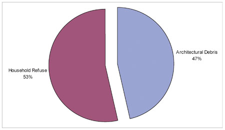 Figure 39. Comparison of household refuse and construction-related artifacts from the Charlton occupation layers.
Interestingly, a small quantity of non-domestic ceramic clay crucible fragments was also recovered from the sheet refuse layers (n=15), accounting for less than 1% of the total artifact assemblage, and less than 5% of the total number of ceramics. Crucible fragments were found not only across the front of the Charlton House, but also from the occupation layers of the neighboring wigmaking/tailor shop. In general, crucibles are most commonly found on sites associated with apothecaries, farriers, or metalworkers. Similar crucible fragments were also during the excavations of Richard Charlton's coffeehouse (owned by Edward's brother) on the north side of Duke of Gloucester Street. At the Coffeehouse site the crucible fragments were found in association with a small brick furnace. Instrumental Neutron Activation Analysis (INAA) of the residue found adhering to the bottom of the Coffeehouse crucibles included traces of copper, gold and silver. The small scale of the furnace, and the identification of metals commonly used in colonial coinage, led the archaeologists excavating the site to propose that assaying may have been conducted on the property-i.e., the analysis of a metal alloys to ascertain their ingredients and their proportions. In particular, assayers in eighteenth-century Williamsburg would have tested coins to authenticate their metallic content, and hence their value (Garden et al. 2001). Although no assaying furnace has been located on Lot 22, it remains an interesting possibility that assaying may have also existed on the property as well.
Fragments of tobacco pipes were also common among the household artifacts. The tobacco pipes with measurable bore diameters were also used to date the accumulation of the layers. A mean date was calculated for tobacco pipe stems with measurable bore diameters using Lewis Binford's straight-line regression formula. Although based on an admittedly small sample size (n=90), the calculated date for the pipe stems was 1773.62. A Harrington histogram of the distribution of the tobacco pipe stems bore diameters was also produced (Figure 40) which exhibited a distribution that most closely corresponds to the Harrington histogram time period of 1750-1800. In general, the tobacco pipe stem mean date and date range are both consistent with
74
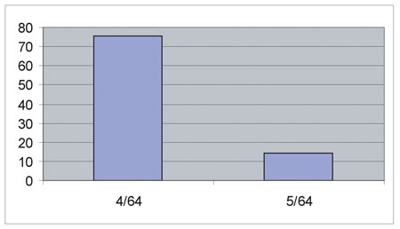 Figure 40. Tobacco pipe stems from the Charlton occupation layers.
the association of the layer with the Charlton family in the second half of the eighteenth century.
The household refuse also included various different glass fragments representing a variety different vessel types and forms. Glass from the Charlton-period contexts accounted for 16% of the total assemblage, and included fragments of wine bottle glass, container glass, case bottle glass, and table glass. Similar to the ceramics, glass vessels associated with both storage (wine, case, and container glass) and dining (table glass) were found mixed together across the front of the house also suggesting a mixed deposit of kitchen and table refuse.
Figure 40. Tobacco pipe stems from the Charlton occupation layers.
the association of the layer with the Charlton family in the second half of the eighteenth century.
The household refuse also included various different glass fragments representing a variety different vessel types and forms. Glass from the Charlton-period contexts accounted for 16% of the total assemblage, and included fragments of wine bottle glass, container glass, case bottle glass, and table glass. Similar to the ceramics, glass vessels associated with both storage (wine, case, and container glass) and dining (table glass) were found mixed together across the front of the house also suggesting a mixed deposit of kitchen and table refuse.
A small quantity of personal items and small finds were also recovered accounting for less than 3% of the total assemblage. Personal items included a child's marble, a glass jewelry stone, fan parts, and a bone hatpin. Other small finds included gunflints, numerous upholstery tacks, and a table knife. Artifacts probably spilling over from the refuse of the neighboring wigmaking and tailoring businesses were also recovered including straight pins, buckles, and a bone button blank.
Also included as household refuse was animal bone and oyster shell. The bone and shell recovered from the Charlton-period contests represented the remains of the meals consumed by the Charlton family in the late eighteenth century (Table 8). In comparison to the other artifact categories, the bones and shells combined to comprise 20% of the total assemblage. The Charlton-period faunal assemblage contained some 1036 bones, 129 identifiable (12.5%) and 907 unidentifiable (87.5%). At least twelve different species were identified: one fish, one amphibian, four birds, and six mammals. Four domestic species were identified: chicken, pig, cow and sheep/goat. Other species included one commensal animal (a rat) and two species of wild animals.
Sturgeon (Acipenser spp.) was the only fish species identified from the deposit. Sturgeon is a bottom dwelling andromenous fish which spawns in fresh or brackish water in the spring. A mature Sturgeon may be more than six feet long and weight over one hundred fifty pounds (Lippson and Lippson 1984). The sturgeon remains 75
| NISP | Weight | Biomass | ||||
|---|---|---|---|---|---|---|
| No. | Pct. | (g) | Pct. | (kg) | Pct. | |
| Fish | ||||||
| Class Osteichthyes (Bony Fish) | 7 | 06. | 0.6 | 0.0 | 0.021 | 0.0 |
| Acipenser spp. (Sturgeon) | 10 | 0.9 | 6.2 | 0.4 | 0.150 | 0.6 |
| Amphibians and Reptiles | ||||||
| Order Testudines (Turtle) | 3 | 0.2 | 2.0 | 0.1 | 0.050 | 0.2 |
| Birds | ||||||
| Class Aves (Bird) | 31 | 2.9 | 6.7 | 0.4 | 0.117 | 0.5 |
| Class Aves/Mammalia III (Bird/Small Mammal) | 26 | 2.5 | 5.7 | 0.4 | 0.100 | 0.4 |
| Duck spp. (Duck) | 5 | 0.4 | 3.8 | 0.2 | 0.069 | 0.3 |
| Family Phasianidae (Grouse, Partridge or Pheasant) | 1 | 0.1 | 1.8 | 0.1 | 0.035 | 0.1 |
| Meleagris gallopavo (Turkey) | 2 | 0.1 | 1.7 | 0.1 | 0.033 | 0.1 |
| Gallus gallus (Chicken) | 4 | 0.3 | 2.7 | 0.1 | 0.050 | 0.2 |
| Mammals | ||||||
| Class Mammalia (Mammal) | 409 | 39.4 | 114.6 | 8.0 | 1.876 | 8.5 |
| Class Mammalia I (Large Mammal) | 137 | 13.2 | 309.7 | 21.8 | 4.590 | 20.9 |
| Class Mammalia II (Medium Mammal) | 281 | 27.1 | 247.8 | 17.4 | 3.756 | 17.1 |
| Class Mammalia III (Small Mammal) | 9 | 0.8 | 3.8 | 0.2 | 0.087 | 0.3 |
| Sylvilagus spp. (Cottontail) | 1 | 0.1 | 0.3 | 0.0 | 0.009 | 0.0 |
| Rattus spp. (Old World Rat) | 1 | 0.1 | 0.0 | 0.0 | 0.002 | 0.0 |
| Order Artiodactyla I (Sheep, Goat, Deer, or Pig) | 4 | 0.3 | 16.3 | 1.1 | 0.324 | 1.4 |
| Order Artiodactyla II (Sheep, Goat or Deer) | 3 | 0.2 | 10.6 | 0.7 | 0.220 | 1.0 |
| Sus scrofa (Domestic Pig) | 53 | 5.1 | 120.0 | 8.4 | 1.956 | 8.9 |
| cf. Sus scrofa (Domestic Pig) | 3 | 0.2 | 3.9 | 0.2 | 0.090 | 0.4 |
| Odocoileus virginianus (White-tailed Deer) | 4 | 0.3 | 21.4 | 1.5 | 0.414 | 1.8 |
| Bos taurus (Domestic Cow) | 29 | 2.8 | 478.4 | 33.7 | 6.789 | 31.0 |
| cf. Bos taurus (Domestic Cow) | 1 | 0.1 | 5.1 | 0.3 | 0.114 | 0.5 |
| Bos taurus (Domestic Cow/Calf) | 6 | 0.5 | 32.6 | 2.3 | 0.605 | 2.7 |
| Ovis aries/Capra hircus (Domestic Sheep or Goat) | 6 | 0.5 | 21.5 | 1.5 | 0.416 | 1.9 |
| Fish | 17 | 1.5 | 6.8 | 0.4 | 0.171 | 0.6 |
| Amphibian and Reptile | 3 | 0.2 | 2.0 | 0.1 | 0.050 | 0.2 |
| Bird | 69 | 6.3 | 22.4 | 1.3 | 0.404 | 1.6 |
| Mammal | 947 | 90.7 | 1386.0 | 97.1 | 21.248 | 96.4 |
| Total Identified | 129 | 11.7 | 7014 | 49.9 | 10.782 | 49.3 |
| Total Unidentified | 907 | 88.3 | 715.9 | 50.1 | 11.091 | 50.7 |
| Grand Totals | 1036 | 100.0 | 1417.3 | 100.0 | 21.873 | 100.0 |
Three turtle bones were recovered from the Charlton period layers and features, but a species-level of identification was not possible. The most common species found in the area are the snapping turtle (Chelhydra serpentina) and the box turtle (Terrepene carolina). The snapping turtle is a large turtle, and prefers shallow water with soft mud bottoms, but also enters brackish tide pools (Ernst and Barbour 1972). On the other hand, box turtles favor open woodlands, pastures, and marshy meadows.
Birds species represented in the assemblage included duck (Duck spp.), chicken (Gallus gallus), turkey (Meleagris gallopavo) and a game bird whose species could not be accurately determined (Family Phasianidae). Duck was the most common, followed by chicken, and turkey and the game bird.
Wild mammals identified from the assemblage include Eastern cottontail (Sylvilagus spp.), rat (Rattus spp.), and white-tailed deer (Odocoileus virginianus). Rabbits were easily hunted and were prepared by roasting or in stews. While-tailed deer, represented by only four elements, was a common food source during the colonial period. However, as the colony expanded, and deer were over-hunted, their populations declined significantly by the late eighteenth century from their seventeenth-century numbers. Nevertheless, deer remained an important part of the colonial diet. The rat was not likely part of the colonial diet, but rather was a commensal species that lived in the vicinity, possibly under the Charlton porch.
Pig, cow, and sheep/goat made up the domestic mammals, and were most likely the remains of meals, the vast majority of which was purchased at the local market. Pig and cow were by far the most abundant species represented in the assemblage. Pig remains accounted for 43.4% of the NISP, followed by cow which accounted for 27.9%. In terms of biomass, the values are reversed. Cow accounts for 34.2% of the total biomass from the assemblage, while pig accounts for only 9.3%.
Finally, the architectural debris that accounted for 47% of the sheet refuse artifacts from the layer consisted of nails, window glass, and a small number of window leads. The nails accounted for 18% of the total assemblage, window glass accounted for 29%, and window leads for less than 1%.
Edward Charlton Wigmaker Shop/James Slate's Tailor Shop
The original store or workshop that stood on the northwest corner of Lot 22 was torn down and replaced with a larger building probably around the same time as the present Charlton House was constructed, thus leaving only a narrow 1.25 m (4.1 foot) wide alleyway between the two structures. The archaeological and historical research suggests that this new building may have originally been used by Edward Charlton for his wigmaking shop, and subsequently by James Slate for his tailor shop. Late eighteenth-century insurance maps of the property indicate that the building was converted into an office by the turn of the century.
77Shop Foundation7
In 2002, only a portion of the east wall (09PC-60) of the shop was exposed, although Glenn Kirk's 1966 excavations exposed the foundations of nearly the entire building (Figure 41). As previously discussed, the building measured 9.15 m (30'0") deep and 7.93 m (26'0") wide, with the front two-thirds of the building separated from the rear portion by a large chimney and partition wall located 5.95 m (19'6") south of the front wall. A portion of the south foundation wall of the original shop was preserved and reused as a footing for a partition in the new building. A variation in the brickwork in the east wall to the south of the dividing wall further suggests that the southern third of the structure may have originally been a shed rather than a continuation of the north portion. Additionally, the footings of a front stoop were found positioned off center along the north elevation of the building, and a brick pier used to support a wood floor was found within the interior of the building (Kirk 1967:19-24).
 Figure 41. Charlton/Slate shoop foundations (Figure 2, G. Kirk 1967)
As a result of his excavations Kirk determined that the second-period building's construction occurred around 1770 (Kirk 1967:25). He also found "no intervening stratigraphy representing either the destruction of the first period building or an accumulation which could have been deposited after the destruction of the first building and before the construction of [the second building]." As a result Kirk further concluded, "the destruction of the first period, therefore, would appear to have been quickly followed by the construction of the [second building]" (Kirk 1967:19) .
The extant foundation examined in 2002 consisted of three courses of brick, one brick thick, and laid in English bond (alternating courses of stretchers and headers; Figure 42). Although only the east wall of the structure was exposed, the limited excavations confirmed many of Kirk's earlier conclusions regarding the building. In particular, the foundation bricks were laid directly over the Early Sheet Refuse Layer (M2), with no evidence of a builder's trench in which to seat the foundation, and with no evidence of any destruction rubble from the earlier structure, thus reaffirming Kirk's assessment that the construction of the building occurred shortly after the demolition of the first. In addition, the lack of a builder's trench suggests that the building's foundations were seated directly on the ground surface.
Shop Occupation Layers
Corresponding to the brick foundation, Kirk's excavations also identified several debris layers that were determined to have accumulated during the occupation of the shop which have been useful for interpreting the occupation and use of the building. A layer of rubble and trash (ER1143N, ER1145R)8 was enclosed within the interior of the building's foundations and was sealed by a layer of plaster associated with a late-eighteenth-century renovation of the structure (ER1143K, ER1154H, ER1145Q, ER1154C; see Figure 18). Kirk observed that the foundation enclosed the entire area of the rubble and trash, and there was no indication that an opening had been created through which the artifacts could have been thrown in. Cracks in the floor were also discounted as a portal through which the artifacts could have made their way into the interior of the foundation because of the large size of many of the artifacts. Instead,
78
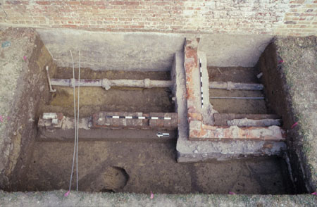 Figure 42. Photograph of the east foundation wall of the Charlton/Slate shop.
79
Kirk proposed that at some point the floor or a portion had to have been removed or was opened to allow the objects to be deposited. Kirk further supported his hypothesis on the basis of the layer's late eighteenth-century artifacts recovered from the layer, most of which were not manufactured until well after the construction of the building (Kirk 1967:27-30).
Figure 42. Photograph of the east foundation wall of the Charlton/Slate shop.
79
Kirk proposed that at some point the floor or a portion had to have been removed or was opened to allow the objects to be deposited. Kirk further supported his hypothesis on the basis of the layer's late eighteenth-century artifacts recovered from the layer, most of which were not manufactured until well after the construction of the building (Kirk 1967:27-30).
Intact portions of the rubble and trash layer (M6) were also excavated in 2002 and were similarly found abutting the interior of the late shop's foundation, confirming that the accumulation had to post-date the construction of the shop. In addition, the layer was also sealed by a continuation of the same layer of plaster (09PC-62) that Kirk observed, thus confirming that the rubble and trash layer had accumulated during the life of the building. The excavated rubble and trash layer measured approximately 10 cm thick and consisted of a very dark grayish brown (2.5Y3/1) silt loam and contained a large number of artifacts (n=485). Among the artifacts were sherds of late eighteenth-century ceramics such as creamware and shell-edged pearlware-similar to examples that were recovered during the 1966 excavations (Kirk 1967:29). A TPQ for the rubble and trash excavated in 2002 was 1780. Other artifacts that were recovered included fragments of wine bottle glass, table glass, container glass, tobacco pipes, nails, window glass, animal bone, in addition to small items such as buttons, clothes buckles, and straight pins, among others (Table 9). Once again, determining how the rubble and trash layer got under the floorboards of the building remains unclear, although Kirk's hypothesis that the floor was temporarily removed is certainly a plausible scenario.
Along the exterior of the shop's foundation, between the shop and the Charlton House, portions of two additional layers of refuse that correspond with the occupation of the shop were also identified. Abutting the exterior of the east foundation wall, and deposited directly over Early Sheet Refuse Layer (M2), was a 3 cm thin layer of light yellowish brown (10YR6/4) sand (09PC-67). Directly over the sand was an equally thin layer of mottled brown (7.5YR4/3 and 7.5YR5/2) clay (09PC-61; see Table 9). A handful of eighteenth-century artifacts were recovered from the two layers (n=94). The fact that both layers abut the foundation indicates that the layers formed around the foundation. Unfortunately, only a narrow length of each layer along the store foundation remained intact. The installation of a sewer line for the Charlton House in the nineteenth century displaced most of both layers between the two structures. Because it is impossible to discern the historical extents of either layer, it is impossible to determine why they were deposited, or how they were formed.
Two additional debris layers related to the occupation of the shop were also found to the north of the structure. These included a layer of mottled sand and debris (09PC-90) that was sealed by a layer of ash and charcoal (09PC-89). The TPQ's of the layers were 1775 and 1783 respectively. Both layers contained a fairly substantial quantity of late eighteenth-century artifacts (n=402) and probably represent sheet refuse deposited as the result of the daily discard of refuse by the occupants of the shop (see Table 9). Although neither layer was found in direct association with the shop ruins, both were located very close to the shop's north wall. Significantly, the artifacts recovered from both of these layers were dated to the same time period as 80
| Rubble & Trash | East of Shop | North of Shop | Total | Percent | |
|---|---|---|---|---|---|
| Tin Glazed | |||||
| Delftware | 2 | - | 18 | 20 | 2.0 |
| Coarse Earthenware | |||||
| N. Midlands Slip | - | - | 2 | 2 | 0.2 |
| Black Glazed Redware | - | - | 1 | 1 | 0.1 |
| Red Sandy | - | 3 | 2 | 5 | 0.5 |
| Stonewares | |||||
| American | 1 | - | - | 1 | 0.1 |
| White Salt Glazed | - | 2 | 5 | 7 | 0.7 |
| Fulham | - | 1 | 1 | 2 | 0.2 |
| Other | - | - | 1 | 1 | 0.1 |
| Porcelain | |||||
| Chinese | 2 | - | 5 | 7 | 0.7 |
| Other | 1 | - | - | 1 | 0.1 |
| Refined Earthenware | |||||
| Whieldon | - | - | 1 | 1 | 0.1 |
| Creamware | 5 | - | 14 | 19 | 1.9 |
| Pearlware | 9 | - | 1 | 10 | 1.0 |
| Other | 1 | - | 2 | 3 | 0.3 |
| Refractory Clay | 1 | - | 2 | 3 | 0.3 |
| Glass | |||||
| Wine Bottle | 20 | 4 | 34 | 58 | 5.9 |
| Container | 26 | 1 | 10 | 37 | 3.8 |
| Table | 14 | - | - | 14 | 1.4 |
| Case Bottle | 4 | - | 5 | 9 | 0.9 |
| Tobacco Pipes | 10 | 12 | 12 | 34 | 3.5 |
| Architectural | |||||
| Nails | 90 | 29 | 159 | 278 | 28.3 |
| Window Glass | 200 | 6 | 80 | 286 | 29.2 |
| Slate | 3 | - | - | 3 | 0.3 |
| Faunal | 11 | - | - | 11 | 1.1 |
| Oyster Shell | 11 | - | - | 11 | 12.5 |
| Other | 23 | 1 | 23 | 47 | 4.8 |
| Total | 485 | 94 | 402 | 981 | 100.0 |
| NISP | Weight | Biomass | ||||
|---|---|---|---|---|---|---|
| No. | Pct. | (g) | Pct. | (kg) | Pct. | |
| Fish | ||||||
| Class Osteichthyes (Bony Fish) | 2 | 1.5 | 0.0 | 0.0 | 0.001 | 0.0 |
| Family Sciaendae (Croaker or Drum) | 1 | 0.7 | 1.0 | 0.2 | 0.028 | 0.4 |
| Birds | ||||||
| Class Aves (Birds) | 8 | 6.1 | 2.1 | 0.5 | 0.040 | 0.5 |
| Class Aves/Mammalia III (Bird/Small Mammal) | 7 | 5.3 | 0.6 | 0.1 | 0.013 | 0.1 |
| Duck spp. (Duck) | 1 | 0.7 | 0.3 | 0.0 | 0.007 | 0.1 |
| Gallus gallus (Chicken) | 1 | 0.7 | 0.1 | 0.0 | 0.003 | 0.0 |
| Mammals | ||||||
| Class Mammalia (Mammal) | 61 | 46.9 | 19.6 | 4.8 | 0.383 | 5.5 |
| Class Mammalia I (Large Mammal) | 12 | 9.2 | 52.3 | 12.8 | 0.926 | 13.5 |
| Class Mammalia II (Medium Mammal) | 14 | 10.7 | 13.1 | 3.2 | 0.268 | 3.9 |
| Ondatra zibethica (Muskrat) | 1 | 0.7 | 0.3 | 0.0 | 0.009 | 0.1 |
| Rattus spp. (Old World Rat) | 1 | 0.7 | 0.2 | 0.0 | 0.006 | 0.0 |
| Order Artiodactyla I (Sheep, Goat, Deer, or Pig) | 1 | 0.7 | 0.4 | 0.1 | 0.012 | 0.1 |
| Sus scrofa (Domestic Pig) | 13 | 10.0 | 75.5 | 18.5 | 1.289 | 18.8 |
| Ovis aries/Capra hircus (Domestic Sheep or Goat) | 3 | 2.3 | 44.2 | 10.8 | 0.796 | 11.6 |
| Fish | 3 | 2.2 | 1.0 | 0.2 | 0.029 | 0.4 |
| Bird | 17 | 12.8 | 3.1 | 0.6 | 0.063 | 0.7 |
| Mammal | 110 | 84.2 | 403.9 | 98.7 | 6.762 | 98.3 |
| Total Identified | 26 | 20.0 | 320.3 | 78.5 | 5.223 | 76.2 |
| Total Unidentified | 104 | 80.0 | 87.8 | 21.5 | 1.631 | 23.8 |
| Grand Totals | 130 | 100.0 | 408.1 | 100.0 | 6.854 | 100.0 |
Only a very small number (n=130) of animal bones were recovered from the various shop occupation layers. Of these, only 26 could be identified to species, leaving 104 bones as unidentifiable (Table 10). Among the species recovered from these contexts include: fish (croaker or drum), duck, muskrat, rat, pig, cow, and sheep goat. With the exception of the rat, the rest of the bones were undoubtedly the refuse from past meals. Domestic mammals bones were by far the most common elements recovered. Pig bones (n=13) were most common, making up half of the total number of identifiable bones, and 18.8% of the total biomass. Although only four cow bones were recovered, they represented 44.8% of the total biomass. Finally, three sheep/goat bones were recovered, representing 11.6% of the total biomass. In an attempt to discern who may have occupied the structure, and what the function of the structure may have been, archaeologist Glenn Kirk noted, "the presence 82 of wig curlers in the vicinity of the second building" (Kirk 1967:25) . The recovery of the wig curlers in association with property owned by Edward Charlton, a well-known wigmaker, lead Kirk to conclude that this was the site of Edward Charlton's wigmaking shop.9 Kirk further argued that the irregularly-sized chimney in the structure might have been a specialized type of chimney designed specifically for the baking of wigs. In 2002, no wig curlers were found in the excavated layer of rubble and trash, nor were any wig curlers or any other wigmaking related artifacts found in any of the occupation layers to the east or north of the store ruins, although eighteen wig curlers were recovered from contexts around the neighboring Charlton House, sixteen of which were recovered from contexts dating to the Charlton period.
Edward Charlton is a logical candidate to have occupied the store, an assertion that is supported by the location of his residence next door and by the recovery of wig curlers from across the site. Unfortunately, there are no known documentary references to the location of Charlton's shop corresponding to this period.10 Further complicating the matter, recent documentary research has also determined that between 1774 and 1780, James Slate, a tailor, maintained his shop as "the second Door below Mr. Anderson's Tavern." Known today as Wetherburn's Tavern, "Mr Anderson's Tavern" is located on the adjacent lot to the west (Lot 21). To the east of the tavern, John and William Rowsay's jewelry shop stood on the northeast corner of Lot 21 "below Mr. Anderson's Tavern," thus making the building on the northwest corner of Lot 22 "the second Door below" the tavern, and therefore the likely location of Slate's shop. In addition to the documentary evidence, artifacts commonly associated with the tailoring trade were also recovered from the rubble and trash layer including a lead bale seal probably used for a bundle of wool, clothes buttons, copper alloy and iron alloy buckles, and straight pins (Figure 43). The 1966 excavations also recovered similar objects, including a thimble, scissors, and straights pins from the layer of rubble and trash, along with additional buttons, straight pins, buckles, etc. which were recovered from the destruction layers of the shop and other later and disturbed contexts as well.
By carefully considering all the archaeological and documentary evidence together, it is possible to piece together the early history of the small shop on the northwest corner of Lot 22 that includes both Edward Charlton and James Slate as occupants. The building was most likely constructed around the time of the construction of the present-day Charlton House, and came into the possession of Edward Charlton in the late 1760s. As previously discussed, an account book of Edward Charlton's documents his transactions as a wigmaker in Williamsburg between 1769 and 1774. During this period, Charlton probably used the small building next to his house as his shop until around 1774, the year in which entries in the account book end. Although there is
83
 Figure 43. Tailor-related artifacts.
no specific documentary references to the location of Charlton's shop during this period, the recovery of the wig curlers from around the building ruins suggest that it may have been located within the building. After 1774, the year in which the account book ends, and Charlton began to advertise the availability of his house for rent, and states his intension to return to his native England. That same year, James Slate began to advertise the opening of his tailor shop on Lot 22. Not surprisingly, tailoring-related items were common among the collection of artifacts recovered from the rubble and trash layer (TPQ = 1780), which is contemporary with the end of Slate's tenure in Williamsburg.
In summary, from the above-described archaeological and documentary evidence, Edward Charlton was operating his wigmaking shop in the building possibly as early as 1769, and continued at that location until 1774. After Charlton closed his shop, he rented the empty storefront to James Slate, who opened his tailoring business in the building, and occupied it until the end of the decade when he relocated to Richmond.
Figure 43. Tailor-related artifacts.
no specific documentary references to the location of Charlton's shop during this period, the recovery of the wig curlers from around the building ruins suggest that it may have been located within the building. After 1774, the year in which the account book ends, and Charlton began to advertise the availability of his house for rent, and states his intension to return to his native England. That same year, James Slate began to advertise the opening of his tailor shop on Lot 22. Not surprisingly, tailoring-related items were common among the collection of artifacts recovered from the rubble and trash layer (TPQ = 1780), which is contemporary with the end of Slate's tenure in Williamsburg.
In summary, from the above-described archaeological and documentary evidence, Edward Charlton was operating his wigmaking shop in the building possibly as early as 1769, and continued at that location until 1774. After Charlton closed his shop, he rented the empty storefront to James Slate, who opened his tailoring business in the building, and occupied it until the end of the decade when he relocated to Richmond.
Russell Family Features
William Russell, a local clerk, purchased the house and property on Lot 22 from Edward Charlton's heirs in 1795. Upon his death in 1812, his daughter, Catherine Russell inherited the property and held title to it until 1819. The only archaeological evidence to Russell family's twenty-four year occupation was a layer of debris from the renovation of Charlton/Slate storefront adjacent to the main house. The debris was primarily plaster, and was concentrated within the interior of building's foundations. Complimenting the archaeological evidence is a 1796 insurance plat of the property (Figure 44) which identifies a one-story office of wood measuring 30' by 26' and
84
 Figure 44. Copy of 1796 Mutual Assurance Society map of Lot 22.
valued at $150 adjacent to the main house. The dimensions of the office given on the plat correspond exactly with the dimensions of the archaeological ruins of the building identified as Charlton/Slate storefront.11 The evidence from the plat, combined with the archaeological evidence indicates that after Russell purchased the property, he converted the former shop into an office.
Figure 44. Copy of 1796 Mutual Assurance Society map of Lot 22.
valued at $150 adjacent to the main house. The dimensions of the office given on the plat correspond exactly with the dimensions of the archaeological ruins of the building identified as Charlton/Slate storefront.11 The evidence from the plat, combined with the archaeological evidence indicates that after Russell purchased the property, he converted the former shop into an office.
Shop Renovation
William Russell's makeover of the Charlton/Slate workshop into an office was evidenced by a layer of plaster (09PC-62) deposited immediately over the rubble and trash layer (M6) associated with James Slate's occupation of the structure. The layer was found across the interior of the building in the 1966 excavations (ER1143K, ER1145H, ER1145Q, ER1154C), as well as, within the narrow excavations carried out in 2002 (Figure 45). A small number of artifacts were recovered from the layer in 2002, including a single creamware fragment, wine bottle glass, animal bone, oyster shell, nails and window glass. The TPQ of the plaster layer was 1775, determined from a cylindrical dip-molded wine bottle base, although Kirk's excavations recovered a Liberty head (with cap) one-cent piece of the design issued in 1795 and 1796, thus linking the deposit with Russell's acquisition of the property. Unfortunately, there exists no archaeological or historical evidence as to how Russell used the office or on the type of business that might have been conducted in the building (Kirk 1967:30).
Henley and Servant Family Features
Williamsburg Land Tax Records in 1819 list Leonard Henley with "1 lot valued at $100 via Catherine C. Russell-a certain house and lot late the residence of said C.C. Russell" (Stephenson 1957)
, a reference undoubtedly denoting Lot 22. Henley died in
85
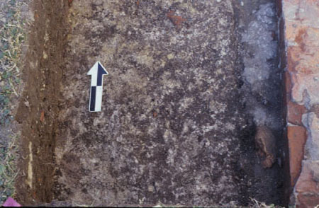 Figure 45. Crushed plaster layer within the interior of the Charlton/Slate shop.
1831, but his heirs continued to own the property, or parts thereof, through the nineteenth century. The Servant family acquired a portion of the property in 1886, and eventually conveyed the property to Colonial Williamsburg in 1928.
Figure 45. Crushed plaster layer within the interior of the Charlton/Slate shop.
1831, but his heirs continued to own the property, or parts thereof, through the nineteenth century. The Servant family acquired a portion of the property in 1886, and eventually conveyed the property to Colonial Williamsburg in 1928.
Similar to the lot's previous owners, Henley insured the property in 1823 (Figure 46), although the plat depicts only the dwelling house and a kitchen, suggesting that William Russell's office was no longer standing by that date. Extensive demolition debris associated with the dismantling of the aforementioned shop/office was among the best preserved nineteenth-century archaeological evidence found in 2002. In contrast, features associated with the nineteenth-century occupation of the dwelling house were scarcely recovered from anywhere around the house. The combination of the house's nineteenth-century remodeling, including the construction of several additions, and the extensive earthmoving during the restoration of the house by Colonial Williamsburg in the 1930s, appears to have obliterated most of the archaeological evidence of the house's nineteenth-century occupation. As a result, the only evidence of the house's nineteenth-century occupation was limited to the remnants of thin mid-century refuse layers, and two small brick piers along the house's southern elevation.
Shop/Office Demolition
The archaeological evidence of the demolition of the shop/office suggests that the demise of the building occurred circa 1820, possibly corresponding with the purchase of the property by Leonard Henley from Catherine Russell. As mentioned above, the building was definitely no longer standing by 1823 according to an insurance plat made in that year which makes no mention of the building. Russell may have torn the nearly fifty-year-old building down, in order to make the property appear more attractive for sale, or perhaps Henley tore the building down after he purchased the property from Russell as part of a series of improvements to the property that would continue through the nineteenth century. In either instance, the dates of the artifacts recovered from the building's demolition layers clearly situate its demise at the time of the property transfer.
86 Figure 46. Copy of 1823 Mutual Assurance Society map of Lot 22.
Debris layers associated with the building's demolition were found and excavated in both 1966 (ER1143H, ER1145N) and 2002 (M10). The layer consisted of a dark brown (10YR3/3) silty clay loam mixed primarily with architectural debris including brick fragments, window glass, and nails, as well as, with a variety of early nineteenth-century domestic artifacts (Table 11). A total of 1670 artifacts were recovered from the demolition layers in 2002, only two of which had TPQs that post-dated 1820-a wire nail and a small fragment of Latent's patent glass, both of which were likely intrusive artifacts which worked their way into the loose jumble of debris from the shop. Similarly, Kirk reported that the artifacts recovered from his excavations in 1966 all dated to the period of 1810-1820 as well (Kirk 1967:30). The domestic artifacts included ceramics, mostly refined earthenwares, wine bottle glass, table glass, tobacco pipes, and animal bone, among others. While the bricks, nails and window glass were certainly deposited as a result of the shop/office's demolition, the early nineteenth-century date of the artifacts, along with the lack of a known domestic occupation of the shop/office suggests that the domestic refuse was likely associated with materials disposed of or left behind by Catherine Russell as she left the property.
Nineteenth-Century Refuse Layers
In addition to early nineteenth-century household refuse mixed in with the demolition debris from the office/shop, several thin layers of nineteenth-century refuse post-dating 1850 were also recovered from along the north and south elevations of the main house. The artifacts consisted of a typical assortment of late eighteenth- and nineteenth-century ceramic, bottle glass, nails, window glass, and animal bone. Along the south elevation, and to the east of the reconstructed rear porch, a nearly 10 cm thick stratum of very dark grayish brown (2.5Y3/2) sandy clay loam with brick rubble (09PC-12) was found and excavated. The layer had accumulated directly over subsoil, and filled in a 30 cm deep erosion gully that was oriented northwest-southeast and cut through the subsoil (Figure 47). The absence of any intervening stratigraphy between the layer and subsoil, along with the fact that the erosion gully was filled with the same post-1850 debris, indicates that not only that the debris accumulated within the gully in the nineteenth century, but also that subsoil must have been exposed at the 87
| Number | Percent | |
|---|---|---|
| Tin Glazed | ||
| Delftware | 21 | 1.3 |
| Coarsewares | ||
| North Midlands Slip | 3 | 0.2 |
| North Devon | 1 | 0.1 |
| Black-Glazed Redware | 1 | 0.1 |
| Colono | 4 | 0.2 |
| Staff. Mottled | 1 | 0.1 |
| Yorktown-type | 1 | 0.1 |
| Other | 5 | 0.3 |
| Stonewares | ||
| Astbury | 2 | 0.1 |
| White Salt Glazed | 13 | 0.8 |
| Fulham | 1 | 0.1 |
| Westerwald | 4 | 0.2 |
| American Blue and Gray | 1 | 0.1 |
| Other | 2 | 0.1 |
| Porcelain | ||
| Porcellaneous | 1 | 0.1 |
| Chinese | 17 | 0.1 |
| Refined Earthenware | ||
| Whieldon | 1 | 0.1 |
| Creamware | 82 | 4.9 |
| Pearlware | 98 | 5.9 |
| Whiteware | 4 | 0.2 |
| Refractory Clay | 1 | 0.1 |
| Glass | ||
| Wine Bottle | 83 | 5.0 |
| Container | 45 | 2.7 |
| Table | 4 | 0.2 |
| Case Bottle | 15 | 0.9 |
| Tobacco Pipes | 21 | 1.3 |
| Architectural | ||
| Nails | 408 | 24.4 |
| Window Glass | 505 | 30.2 |
| Window Leads | 1 | 0.1 |
| Faunal | 234 | 14.0 |
| Oyster Shell | 42 | 2.5 |
| Other | 47 | 2.8 |
| Total | 1670 | 100.0 |
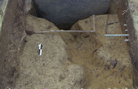 Figure 47. Erosion gully to the south of the Charlton House.
time in order for the erosion gully to have formed in the first place. In order to account for the formation of the erosion gully, and its subsequent filling in the nineteenth century, the bare subsoil must have been exposed-a scenario that most likely as a result of excavations around the house during its remodeling which reduced the depth of the house to nearly half of it's original depth. Although no documentary evidence remains to pin-point the year in which these architectural alterations were made, the formation and filling of erosion gullies through the area's subsoil at mid-century suggests that the architectural changes to the house may have been made around that time.
Figure 47. Erosion gully to the south of the Charlton House.
time in order for the erosion gully to have formed in the first place. In order to account for the formation of the erosion gully, and its subsequent filling in the nineteenth century, the bare subsoil must have been exposed-a scenario that most likely as a result of excavations around the house during its remodeling which reduced the depth of the house to nearly half of it's original depth. Although no documentary evidence remains to pin-point the year in which these architectural alterations were made, the formation and filling of erosion gullies through the area's subsoil at mid-century suggests that the architectural changes to the house may have been made around that time.
Around the front of the main house, along its north elevation, three thin overlapping post-1850 layers were also identified (Figure 48). Sealing the demolition debris from the adjacent shop/office was a lens of brownish yellow (10YR6/6) sandy clay (09PC-80) that ranged in thickness from 2 to 12 cm. The layer was thickest next to the house, and thinned out to the north. Directly overtop of the sandy clay was a 3 cm thin layer of marl (09PC-79) which was often used to surface or pave pathways around structures. The identification of the marl lens along the front of the house suggests that a crude marl path may have once encircled the house, possibly in order to help in covering the debris from the demolition of the adjacent structure. Finally, on top of the marl lens, a dark grayish brown (2.5Y3/2) layer of silty clay (09PC-78) had accumulated. Each of the three layers contained small amounts of architectural and domestic debris, although most of the artifacts were recovered from the layer of silty clay over the marl path. Similar to the layer of debris recovered from along the house's southern elevation, the artifacts consisted of various late eighteenth- and nineteenth-century ceramics, bottle glass, nails, window glass, and animal bone.
A total of 237 animal bones were recovered from contexts relating to the shop demolition and the nineteenth-century refuse disposal. Of these bones, 38 (16%) were identifiable to species, and 199 (84%) were not (Table 12). The species identified include freshwater catfish, black drum, duck, squirrel, pig, cow, and sheep/goat. Similar
89
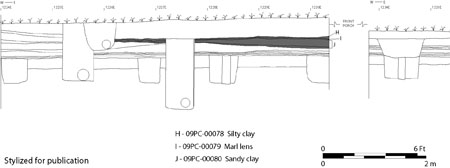 Figure 48. Post-1850 layers north of the Charlton House.
| NISP | Weight | Biomass | ||||
|---|---|---|---|---|---|---|
| No. | Pct. | (g) | Pct. | (kg) | Pct. | |
| Fish | ||||||
| Class Osteichthyes (Bony Fish) | 9 | 3.8 | 0.5 | 0.2 | 0.018 | 0.4 |
| Pogonias cromis (Black Drum) | 1 | 0.4 | 1.5 | 0.6 | 0.039 | 0.8 |
| Family Ictaluridae (Freshwater Catfish) | 1 | 0.4 | 0.3 | 0.1 | 0.016 | 0.3 |
| Birds | ||||||
| Class Aves (Bird) | 16 | 6.7 | 2.4 | 0.9 | 0.045 | 1.0 |
| Class Aves/Mammalia III | 13 | 5.4 | 2.3 | 0.9 | 0.044 | 0.9 |
| Duck spp. (Duck) | 3 | 1.2 | 1.5 | 0.6 | 0.030 | 0.6 |
| Gallus gallus (Chicken) | 7 | 2.9 | 3.7 | 1.5 | 0.067 | 1.5 |
| Mammals | ||||||
| Class Mammalia (Mammal) | 92 | 38.8 | 37.9 | 15.6 | 0.693 | 15.5 |
| Class Mammalia (Large Mammal) | 33 | 13.9 | 50.4 | 20.7 | 0.896 | 20.0 |
| Class Mammalia II (Medium Mammal) | 33 | 13.9 | 34.7 | 14.3 | 0.640 | 14.3 |
| Class Mammalia III (Small Mammal) | 2 | 0.8 | 0.3 | 0.1 | 0.009 | 0.2 |
| Sciurus spp. (Squirrel) | 1 | 0.4 | 0.4 | 0.1 | 0.012 | 0.2 |
| Order Artiodactyla II (Sheep, Goat, or Deer) | 1 | 0.4 | 1.5 | 0.6 | 0.038 | 0.8 |
| Sus scrofa (Domestic Pig) | 20 | 8.4 | 56.1 | 23.1 | 0.986 | 22.1 |
| cf. Sus scrofa (Domestic Pig) | 1 | 0.4 | 2.1 | 0.8 | 0..051 | 1.1 |
| Bos taurus (Domestic Cow) | 2 | 0.8 | 41.6 | 17.1 | 0.754 | 16.9 |
| Ovis aries/Capra hircus (Domestic Sheep or Goat) | 2 | 0.8 | 5.5 | 2.2 | 0.122 | 2.7 |
| Fish | 11 | 4.6 | 2.3 | 0.9 | 0.073 | 1.5 |
| Bird | 39 | 16.2 | 9.9 | 3.9 | 0.186 | 4.0 |
| Mammal | 187 | 78.6 | 230.5 | 94.6 | 4.201 | 93.8 |
| Total Identified | 38 | 16.0 | 112.7 | 46.4 | 2.077 | 46.6 |
| Total Unidentified | 199 | 84.0 | 130.0 | 53.6 | 2.383 | 53.4 |
| Grand Totals | 237 | 100.0 | 242.7 | 100.0 | 4.460 | 100.0 |
Nineteenth-Century Brick Piers
Although the main house had first been reduced in its depth at or before the mid-nineteenth-century, by 1900 the house had been expanded with the addition of several small projecting bays and wings supported on brick piers appended to the rear of the house (Figure 49; Kocher and Dearstyne 1950:1-6). Two small brick piers associated with those additions were found to the south of the house and west of the reconstructed rear porch (Figure 50). Both brick piers were constructed directly on the circa-1850 layer of sandy clay loam with brick rubble that filled the erosion gully and sealed subsoil to the south of the house. The facts that the piers were constructed on top of the layer indicates their construction must post-date 1850, thus giving a very rough approximation of the date after which the additions may have been added. The location of the brick piers to the east of the current reconstructed rear porch suggests that they likely were part of the support system of either the large southeastern addition, or they may have been part of the stair tower located in the center of the house's southern elevation. The remnants of at least three additional piers were found to the east of the reconstructed rear porch during the 1999 archaeological excavations (Fischer n.d.).
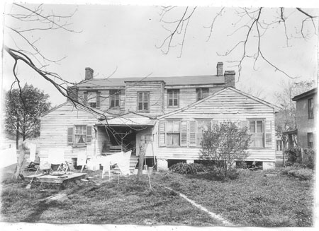 Figure 49. Circa 1928 photograph of the south elevation of the Charlton House.
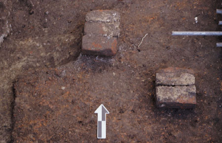 Figure 50. Nineteenth-Century brick piers south of the Charlton House.
Colonial Williamsburg Restoration Features
Colonial Williamsburg restored the Charlton House in 1929-30, at which point the nineteenth-century additions and modifications were removed, and the building was returned to its eighteenth-century dimensions and exterior appearance. The major exception was the addition of a serving pantry added to the west side of the house at the request of the then life tenant, Mary Lou Servient (Kocher and Dearstyne 1950: 1-6). After Ms. Servient vacated the house, the serving pantry was removed and its foundations demolished, although the portions of the foundations located below grade were left in place. Interestingly, the archaeological excavations revealed that the location west foundation wall of the pantry had coincided with the location of the footings of the east wall eighteenth-century shop/office. As a result, during the construction of the pantry, rather than removing the eighteenth-century footings, they were preserved in situ by incorporating them into the modern pantry foundation. Intact portions of the twentieth-century pantry foundations with the eighteenth-century footings were found in place during the 2002 excavations (Figure 51). Finally, in addition to the architectural restoration of the house, the grounds around the house were also renewed once the reconstruction of the house was completed. The most pervasive evidence of this renewal was the extensive fill that was encountered all around the present-day Charlton House. The depth of the fill varied from location to location. Along the north and south elevations of the house, the fill was relatively shallow measuring only a few centimeters. However, to the west of the house and extending over the remains of the shop/office the fill sometimes extended over 60 cm below modern grade. Finally, evidence that the house had been previously "waterproofed" was found all around the house. At a hereto-unknown date (presumably after the 1930 restoration), a wide trench was excavated along the foundation in order to allow for the application of cement to exterior of the foundation which was an attempt to keep water out of the house's basement. Unfortunately, a consequence of this previous attempt to "waterproof" the house, was the extensive disturbance to the house's original builder's trench, and all other evidence pertaining to the construction of the house.
92 Figure 51. Twentieth-century pantry foundation (foreground).
Chapter 5.
Conclusions and Suggestions for Future Research
Conclusions
The archaeological excavations around the Charlton House in 2002 proved to be exceptionally successful, providing significant information about the property that was previously unknown. The limited excavations not only uncovered evidence regarding the construction and occupation of the eighteenth-century Charlton House, but also evidence of a relatively intense occupation of the property prior to the Charlton House's construction. Highlights from the excavations included the identification of an unusually large ditch feature that is believed to have served as a seventeenth-century boundary marker, property line, or drainage ditch prior to the formation of Williamsburg in 1699. The feature represents one of only a small handful of features that can be reliably attributed to the pre-Williamsburg period, and thus is an important clue toward a more complete understanding of the area's seventeenth-century landscape. The excavations also revealed a line of very large postholes that likely supported the wall of a previously unknown earthfast barn or warehouse that was built in the first half of the eighteenth century. Like the ditch feature, the discovery of the earthfast building is also somewhat of a rare find in Williamsburg. Although earthfast buildings were common across much of the seventeenth- and eighteenth-century Chesapeake, few have been found in urban settings. The discovery of the post structure at the Charlton site suggests that the architectural history of Williamsburg was more diverse than has long been assumed. Post-dating the barn/warehouse structure, the northeast corner of a narrow brick foundation for a small structure constructed around the middle of the eighteenth century was also uncovered. Although the structure was known from previous archaeological excavations, this new evidence led to the refinement of our understanding the dimensions of the building. The excavations also revealed additional evidence of another building, one that the documentary and archaeological evidence both indicate was used as a workshop or store first by wigmaker Edward Charlton, and later by a local tailor, James Slate. William Russell, near the end of the eighteenth century, then converted the same building into an office. Finally, limited evidence of the construction of the Charlton House was also found, including a small intact portion of the house's builder's trench. Overlaying the house's construction-related features were several occupation layers dating to the late eighteenth and nineteenth centuries, as well as, the heavily disturbed fragments of a brick paved sidewalk paralleling Duke of Gloucester Street in front of the Charlton House.
Overall, the results of the Charlton House excavations proved to be very exciting, and successfully exemplified how limited stratigraphic archaeological excavations can supply a great deal of valuable new information about the occupation and use of a particular property and the overall development of Williamsburg as well. The discovery of each of the different soil layers, features, building foundations, and the numerous 94 artifacts has greatly enhanced our understanding not only of the house and property, but also about the lives the people who where living and working there.
Suggestions for Further Research
Possibly the most significant discovery of the project was not the identification of a particular feature or artifact, but rather it was the determination of the completeness and relative preservation of the archaeological record in the ground around the house. Although the house and lot have been subject to extensive renovations, repairs, landscaping, and previous archaeological excavation, the 2002 excavations demonstrated that a great deal of information regarding the occupation and development of the property remains preserved in the ground. Among the most surprising discoveries was the identification of previously unknown seventeenth and early eighteenth-century features that pre-dated the construction of the house-even within areas that were thought to have been already thoroughly excavated. As the project progressed, we quickly learned that the fact that these features had not been previously discovered and recorded was not the consequence of substandard fieldwork of our predecessors, but rather as testament to them as stewards of the archaeological record, and their commitment to the preservation of archaeological resources. Case in point, the research design of the archaeological excavations carried out in 1966 were strictly focused on the recovery of information about the succession of eighteenth-century shops and tenements located between the Charlton House and Wetherburn's Tavern for possible reconstruction. Once the desired information about the construction, occupation, and demolition of these structures had been obtained, the excavations were broken off, with full knowledge that additional earlier and potentially exciting deposits still awaited discovery. But rather than needlessly disturbing these unthreatened resources, the archaeologist's test units were backfilled, and the deposits were left for future archaeologists to excavate and study with the hope that in the future more sophisticated techniques of excavation and analysis would enhance their recovery and interpretation. As a result, their deliberate conservation allowed for our discovery. Discoveries that have in turn demonstrated the potential for additional archaeological exploration of the property.
Among the most interesting potential avenues of future research is the area between the Charlton House and Duke of Gloucester Street. The trench along the north elevation of the house encountered very deep intact stratigraphy that spanned from the seventeenth through the nineteenth centuries. Most archaeological research within Colonial Williamsburg's Historic Area has been focused within the interiors of Williamsburg's city lots, with very little archaeological research has been carried out with regard to the roads and fence lines that paralleled and defined them. In addition, Middle Plantation-era features that predate the layout of the town in 1699, may also lie outside of the city lots buried under Williamsburg's eighteenth-century streets and alleyways. The identification of the Middle Plantation-era drainage/irrigation ditch extending diagonally under the Charlton House and under Duke of Gloucester Street and is once such example.12 As already suggested, the study of Middle Plantation-era 95 related features is another exciting potential avenue of future research at the Charlton House property. Once again, the Middle Plantation-era drainage/irrigation ditch most likely continues southwest away from the house, thus strongly suggesting that additional Middle Plantation-era features may also be found to the west and southwest of the house. Finally, all the archaeological excavations on the property has been clustered almost exclusively, around the main house and outbuildings along Duke of Gloucester Street, the remainder of Lot 22 extending south from the house to Francis Street is completely unexplored, with the exception of cross-trenching in the 1930s. Nevertheless, there can be no telling of what unknown, buildings, garden features, boundary ditches, may await discovery elsewhere on the property.
96Footnotes
Bibliography
- 1962
- "A New Method of Calculating Dates from Kaolin Pipe Stem Fragments." Southeastern Archaeological Conference Newsletter 9(1).
- 1998
- "Masonry Architecture in 17th-Century Virginia" Northeast Historical Archaeology, 27:85-120.
- 1986
- Block 9 in the Eighteenth Century: The Social and Architectural Context of the Sheilds Tavern Property. Colonial Williamsburg Archaeological Reports. Colonial Williamsburg Foundation, Williamsburg, Virginia.
- 1990
- Archaeological Investigations of the Shields Tavern Site, Williamsburg, Virginia. Department of Archaeological Research, Colonial Williamsburg Foundation, Williamsburg, Virginia.
- 1959
- "The Charlton House." Manuscript on file at the John D. Rockefeller, Jr. Library, Colonial Williamsburg Foundation, Williamsburg, Virginia.
- 1957
- "Wigmaking in Colonial America." Manuscript on file at the John D. Rockefeller, Jr. Library, Colonial Williamsburg Foundation, Williamsburg, Virginia.
- 1988
- "Women Merchants and Milliners in Eighteenth Century Williamsburg." Manuscript on file at the John D. Rockefeller, Jr. Library, Colonial Williamsburg Foundation, Williamsburg, Virginia.
- 1890
- Volume VIII. Krause Reprint Edition 1968.
- 1981
- "Impermanent Architecture in the Southern American Colonies." Winterthur Portfolio 16(2):135-196.
- 1971
- The Wigmaker in Eighteenth-Century Williamsburg: An Account of his Barbering, Hair-Dressing & Peruke-Making Services, & Some Remarks on Wigs of Various Styles. Williamsburg Craft Series. Colonial Williamsburg Foundation, Williamsburg, Virginia.
- 2002
- Architecture of Early Virginia: An Analysis of the Origins of the Earth Fast Tradition. M.A. thesis, School of Archaeological Studies, University of Leicester, U.K. 98
- 1987
- Archaeology at Port Anne: A Report on Site CL7, An Early 17th-Century Colonial Site. Colonial Williamsburg Archaeological Reports. Colonial Williamsburg Foundation, Williamsburg, Virginia.
- 1988
- A View from the Top: Archaeological Investigations of Peyton Randolph's Urban Plantation. Colonial Williamsburg Archaeological Reports. Colonial Williamsburg Foundation, Williamsburg, Virginia
- n.d.a.
- "Summary of the 1999 Excavations Behind the Charlton House and the King's Arms Tavern Barber Shop." Manuscript on file at the Department of Archaeological Research, Colonial Williamsburg Foundation, Williamsburg, Virginia.
- n.d.b.
- "Memo: A Reinterpretation of the King's Arms Tavern Barber Shop." Manuscript on file at the Department of Archaeological Research, Colonial Williamsburg Foundation, Williamsburg, Virginia.
- 2002
- Personal communication. Department of Archaeological Research, Colonial Williamsburg Foundation.
- 2001
- "The Richard Charlton Coffeehouse: A Story of Archaeology, History, and Hot Drinks in Eighteenth-Century Williamsburg, Virginia." Draft report on file, Department of Archaeological Research, Colonial Williamsburg Foundation, Williamsburg, Virginia.
- 1950
- "John Carter's Store Historical Report, Block 17 Building 7A Lot 53" Manuscript on file at the John D. Rockefeller, Jr. Library, Colonial Williamsburg Foundation, Williamsburg, Virginia.
- 2002
- Personal communication. Department of Architectural Research, Colonial Williamsburg Foundation.
- 1958
- History of Agriculture in the Southern United States to 1860. Carnegie Institution of Washington Publication No. 430. Carnegie Institution, Washington, DC.
- 1984
- Quantitative Zooarcaheology: Topics in the Analysis of Archaeological Faunas. Academic Press, Orlando.
- 1954
- "Dating Stem Fragments of Seventeenth and Eighteenth Century Clay Tobacco Pipes." Quarterly Bulletin of the Archaeological Society of Virginia, 9(1):9-13. 99
- 2003
- "Archaeological Excavations at the James Wray Site." Colonial Williamsburg Interpreter, Winter 2003 23(4):1-13.
- 1989
- "Private Land Development in Williamsburg, 1699-1748: Building A Community." M.A. thesis, American Studies, College of William and Mary.
- 1984
- Kingsmill Plantations, 1619-1800: Archaeology of Country Life in Colonial Virginia. New York: Academic Press.
- 1999
- "18CV85: File Report." Manuscript on file at Jefferson Patterson Park & Museum Library, St. Leonard's, Maryland.
- 1967
- "Charlton House Archaeological Report Block 9 Building 30 Lot 22." Manuscript on file at the John D. Rockefeller, Jr. Library, Colonial Williamsburg Foundation, Williamsburg, Virginia.
- 1980
- Nicholas-Tyler House Block 4 Area. A Report of Excavations Conducted December, 1978. Manuscript on file at the John D. Rockefeller, Jr. Library, Colonial Williamsburg Foundation, Williamsburg, Virginia.
- 1950
- "Charlton House Architectural Report, Block 9 Building 30 Lot 22." Manuscript on file at the John D. Rockefeller, Jr. Library, Colonial Williamsburg Foundation, Williamsburg, Virginia.
- 2000
- Nassau Street Site Summer 1999 Excavations. Colonial Williamsburg Archaeological Reports. Williamsburg, Virginia.
- 1984
- Life in the Chesapeake Bay. The Johns Hopkins University Press, Baltimore.
- 1998
- "Upon the Palisado" and Other Stories of Place from Bruton Heights. Colonial Williamsburg Research Publications. Colonial Williamsburg Foundation, Williamsburg, Virginia.
- 1997
- James City County: Keystone of the Commonwealth. The Donning Company Publishers. Virginia Beach, Virginia.
- 1999
- Interim Report: The Archaeology of Rich Neck Plantation. Colonial Williamsburg Archaeological Reports. 100 Williamsburg, Virginia.
- 2000
- "Telling Time for Archaeologists." Northeast Historical Archaeology, 29:1-22.
- 1997
- Fishes of the Chesapeake Bay. Smithsonian Institution Press, Washington, D.C.
- 1978
- Food. Colonial Williamsburg Archaeological Series No.9. The Colonial Williamsburg Foundation, Williamsburg.
- 2001
- The Archaeology of Martin's Hundred. University of Pennsylvania Museum of Archaeology and Anthropology, Philadelphia and the Colonial Williamsburg Foundation, Williamsburg.
- 1975
- Clay Pipes for the Archaeologist. British Archaeological Reports 14. Oxford.
- 1990
- Governor's Land: Archaeology of Early Seventeenth-Century Virginia Settlements. Charlottesville: University of Virginia Press.
- 2002
- Personal communication. Department of Archaeological Research, Colonial Williamsburg Foundation.
- 1995
- "Landladies and Woman Tenants in Williamsburg and Yorktown: 1700-1770." In Common People and Their Material World: Free Men and Women in the Chesapeake, 1700-1830, edited by David Harvey and Gregory Brown. Colonial Williamsburg Foundation Publications, Williamsburg, Virginia.
- 1979
- Spanish and British Subsistence Strategies at St. Augustine, Florida and Frederica, Georgia Between 1565 and 1783. Ph.D. dissertation, University of Florida, Gainesville.
- 1983
- "Use of Allometry in Zooarchaeological Analysis." In Animals and Archaeology: 2. Shell Middens, Fishes and Birds, edited by Caroline Grigson and Julia Clutton-Brock, pp. 237-252. B.A.R. International Series 183, London.
- 1972
- Tidewater Towns: City Planning in Colonial Virginia and Maryland. The Colonial Williamsburg Foundation. Williamsburg, Virginia. 101
- 1933
- "King's Arms Tavern and Barber Shop Archaeological Report, Block 9 Building 29A & B Lot 23." Manuscript on file at the John D. Rockefeller Jr. Library, Colonial Williamsburg Foundation, Williamsburg, Virginia.
- 1977
- Method and Theory in Historical Archaeology. Academic Press. New York.
- 1949
- "King's Arms Tavern Historical Report, Block 9 Building 29A & B Lot 23." Manuscript on file at the John D. Rockefeller, Jr. Library, Colonial Williamsburg Foundation, Williamsburg, Virginia.
- 1956
- "Alexander Craig House Historical Report, Block 17 Building 5 Lot 55." Manuscript on file at the John D. Rockefeller, Jr. Library, Colonial Williamsburg Foundation, Williamsburg, Virginia.
- 1957
- "Charlton House Historical Report, Block 9 Building 30 Lot 22." Manuscript on file at the John D. Rockefeller, Jr. Library, Colonial Williamsburg Foundation, Williamsburg, Virginia.
- 1958
- "Alexander Purdie House Historical Report, Block 9 Building 28A Lot 24." Manuscript on file at the John D. Rockefeller, Jr. Library, Colonial Williamsburg Foundation, Williamsburg, Virginia.
- 2002
- "Decoding the Message in the Midden: What Can Nineteenth-Century Sheet Refuse Tell Us?" In Nineteenth and Early Twentieth-Century Domestic Site Archaeology in New York State, edited by John P. Hart and Charles L. Fisher. New York State Museum Bulletin 495. University of the State of New York, New York State Education Department, Albany.
- 1997
- "Provisioning Early American Towns. The Chesapeake: A Multidisciplinary Case Study." Final Performance Report.
- 1994
- A Chesapeake Family and Their Slaves: A Study in Historical Archaeology. Cambridge University Press, Cambridge.
Appendix A.
Master Context List
| MC | Description | Context Numbers |
|---|---|---|
| M1 | Middle Plantation Ditch | 09PC-72-73, 191-192 |
| M2 | Early Sheet Refuse Layer | 09PC-21, 36, 45, 68-71,175, 190 |
| M3 | Early Fence Line | 09PC-172-174, 176-188 |
| M4 | Early Post-In-Ground Structure | 09PC-115-118, 131-132, 151-158, 161-165, 167-170 |
| M5 | Mid-Eighteenth-Century Sheet Refuse Layer | 09PC-105, 108, 119, 142 |
| M6 | Rubble and Trash Layer | 09PC-065-66 |
| M7 | Brick Sidewalk | 09PC-92-94, 129 |
| M8 | Ash & Sand Layer | 09PC-95, 102-103, 133 |
| M9 | Clay Cap | 09PC-84, 122-123 |
| M10 | Shop/Office Demolition | 09PC-56-57, 81-83, 87-88 |
Appendix B.
Context Register
| Context No | Trench | Description |
|---|---|---|
| 09PC-00000 | NORTHEAST | CLAY LAYER 2 |
| 09PC-00001 | SOUTHEAST | TOPSOIL |
| 09PC-00002 | SOUTHEAST | SE TRENCH-RESTORATION FILL |
| 09PC-00003 | WEST | TOPSOIL |
| 09PC-00004 | WEST | RESTORATION FILL |
| 09PC-00005 | WEST | FILL WITHIN W. PORCH |
| 09PC-00006 | WEST | FILL IN CORNER, NEAR BULKHEAD |
| 09PC-00007 | SOUTHEAST | PORCH BUILDER'S TRENCH FILL |
| 09PC-00008 | SOUTHEAST | PORCH BUILDER'S TRENCH CUT |
| 09PC-00009 | SOUTHEAST | WATERPROOFING FILL |
| 09PC-00010 | SOUTHEAST | CUT FOR 00009 |
| 09PC-00013 | SOUTHEAST | PIPE UTILTY TRENCH |
| 09PC-00014 | SOUTHEAST | CUT FOR PIPE UTILITY TRENCH |
| 09PC-00015 | WEST | N-S UTILITY TRENCH FILL |
| 09PC-00016 | WEST | N-S UTILITY TRENCH CUT |
| 09PC-00017 | WEST | E-W UTILITY TRENCH FILL |
| 09PC-00018 | WEST | E-W UTILITY TRENCH CUT |
| 09PC-00019 | WEST | OLD WATERPROOFING BACKFILL |
| 09PC-00020 | WEST | OLD WATERPROOFING CUT |
| 09PC-00021 | WEST | OLIVE BROWN SILT LOAM |
| 09PC-00022 | WEST | NOEL HUME POSTHOLE EXCAVATION FILL |
| 09PC-00023 | WEST | CUT FOR NOEL HUME POSTHOLE EXCAVATION |
| 09PC-00024 | WEST | S. POSTHOLE FILL |
| 09PC-00025 | WEST | CUT FOR SOUTH POSTHOLE |
| 09PC-00026 | WEST | POSTMOLD FILL |
| 09PC-00027 | WEST | POSTHOLE FILL |
| 09PC-00028 | WEST | POSTHOLE CUT |
| 09PC-00029 | WEST | NOEL HUME POST HOLE FILL |
| 09PC-00031 | WEST | POSTHOLE FILL |
| 09PC-00032 | WEST | POSTHOLE CUT |
| 09PC-00033 | EAST | MOTTLED CLAY FILL |
| 09PC-00034 | EAST | ORANGE SAND WITH MARL |
| 09PC-00035 | EAST | REDEPOSITED CLAY |
| 09PC-00036 | WEST | BROWN SANDY LOAM LAYER (WHEEL WELL) |
| 09PC-00037 | SOUTHEAST | CUT FOR WATER-WORN GULLY |
| 09PC-00038 | WEST | SMALL POST MOLD |
| 09PC-00039 | WEST | SMALL POST HOLE FILL |
| 09PC-00040 | WEST | SMALL POST HOLE CUT |
| 09PC-00041 | WEST | MODERN PORCH FOUNDATION |
| 09PC-00042 | WEST | SHOP/OFFICE FOUNDATION |
| 09PC-00043 | WEST | SMALL PLANTING FEATURE FILL |
| 09PC-00044 | WEST | SMALL PLANTING FEATURE CUT |
| 09PC-00045 | WEST | OLIVE BROWN SILT LOAM |
| 09PC-00046 | WEST | POSTMOLD IN E-W UTILITY TRENCH |
| 09PC-00047 | WEST | POSTHOLE FILL IN E-W UTILITY TRENCH |
| 09PC-00048 | WEST | POSTHOLE CUT IN E-W UTILITY TRENCH |
| 09PC-00049 | WEST | POSTHOLE FILL IN N-S UTILITY TRENCH |
| 09PC-00050 | WEST | POSTHOLE CUT IN N-S UTILITY TRENCH |
| 09PC-00051 | NORTHWEST | TOPSOIL |
| 09PC-00052 | NORTHWEST | FILL WITHIN W. PORCH |
| 09PC-00053 | NORTHWEST | RESTORATION FILL |
| 09PC-00054 | NORTHWEST | OLD WATERPROOFING FILL |
| 09PC-00056 | NORTHWEST | MOTTLED LAYER |
| Context No | Trench | Description |
|---|---|---|
| 09PC-00057 | NORTHWEST | CRUSHED MORTAR LAYER |
| 09PC-00058 | NORTHWEST | NOEL-HUME POSTHOLE FILL |
| 09PC-00059 | NORTHWEST | NOEL-HUME POSTHOLE CUT |
| 09PC-00061 | NORTHWEST | CLAY AND BRICK LAYER |
| 09PC-00062 | NORTHWEST | CRUSHED MORTAR LAYER |
| 09PC-00063 | NORTHWEST | NOEL HUME POST FILL |
| 09PC-00064 | NORTHWEST | NOEL HUME POSTHOLE CUT |
| 09PC-00065 | NORTHWEST | RUBBLE AND TRASH LAYER |
| 09PC-00066 | NORTHWEST | RUBBLE AND TRASH |
| 09PC-00067 | NORTHWEST | SAND LAYER |
| 09PC-00068 | NORTHWEST | OLIVE BROWN SILT LOAM I |
| 09PC-00069 | NORTHWEST | OLIVE BROWN SILT LOAM I |
| 09PC-00070 | NORTHWEST | OLIVE BROWN SILT LOAM II |
| 09PC-00071 | NORTHWEST | OLIVE BROWN SILT LOAM I |
| 09PC-00072 | NORTHWEST | LARGE DTICH FEATURE FILL |
| 09PC-00073 | NORTHWEST | LARGE DITCH FEATURE CUT |
| 09PC-00074 | NORTHWEST | SLOT TRENCH |
| 09PC-00075 | NORTHWEST | SLOT TRENCH CUT |
| 09PC-00077 | NORTH | CLAY DEPOSIT |
| 09PC-00078 | NORTH | MOTTLED CLAY SURFACE |
| 09PC-00079 | NORTH | MARL LAYER |
| 09PC-00080 | NORTH | ORANGE SANDY CLAY |
| 09PC-00081 | NORTH | MORTAR & BRICK RUBBLE |
| 09PC-00082 | NORTH | BRICK SPREAD |
| 09PC-00083 | NORTH | BRICK & MORTAR RUBBLE |
| 09PC-00084 | NORTH | CLAY CAP |
| 09PC-00085 | NORTH | POST HOLE FILL |
| 09PC-00086 | NORTH | POST HOLE FILL |
| 09PC-00087 | NORTH | SREDDISH BROWN SAND/SILT |
| 09PC-00088 | NORTH | BRICK & MORTAR RUBBLE |
| 09PC-00089 | NORTH | BURN LAYER |
| 09PC-00090 | NORTH | MOTTLED SAND & DEBRIS LAYER |
| 09PC-00091 | NORTH | EAST-WEST FOUNDATION |
| 09PC-00092 | NORTH | BRICK FEATURE (SIDEWALK) |
| 09PC-00093 | NORTH | CRUSHED BRICK LENS |
| 09PC-00094 | NORTH | CRUSHED BRICK LENS |
| 09PC-00095 | NORTH | TAN SAND LENS |
| 09PC-00096 | NORTH | EAST ROUND POST HOLE FILL |
| 09PC-00097 | NORTH | EAST ROUND POST HOLE CUT |
| 09PC-00098 | NORTH | M. ROUND POST HOLE FILL |
| 09PC-00099 | NORTH | M. ROUND POST HOLE CUT |
| 09PC-00100 | NORTH | W. ROUND POSTHOLE FILL |
| 09PC-00101 | NORTH | W. ROUND POSTHOLE CUT |
| 09PC-00102 | NORTH | MOTTLED SAND |
| 09PC-00103 | NORTH | ASH LENS |
| 09PC-00105 | NORTH | MOTTLED SURFACE-EAST HALF |
| 09PC-00108 | NORTH | MOTTLED SURFACE-WEST HALF |
| 09PC-00109 | NORTHEAST | W. POSTHOLE FILL |
| 09PC-00110 | NORTHEAST | CUT FOR W. POSTHOLE |
| 09PC-00111 | NORTHEAST | MIDDLE POST HOLE FILL |
| 09PC-00112 | NORTHEAST | CUT FOR MIDDLE POST HOLE |
| 09PC-00113 | NORTHEAST | EAST POSTHOLE FILL |
| 09PC-00114 | NORTHEAST | CUT FOR EASTERN POSTHOLE |
| 09PC-00115 | NORTHEAST | POSTHOLE NO. 1A FILL |
| 09PC-00116 | NORTHEAST | POSTHOLE NO. 1A CUT |
| 09PC-00117 | NORTHEAST | POST HOLE 2B |
| 09PC-00118 | NORTHEAST | POST HOLE 2B CUT |
| 09PC-00119 | NORTH | MOTTLED SURFACE - FAR WEST |
| Context No | Trench | Description |
|---|---|---|
| 09PC-00120 | NORTH | POSTHOLE 3A FILL |
| 09PC-00121 | NORTH | POSTHOLE 3A CUT |
| 09PC-00122 | NORTHEAST | CLAY LAYER 1 |
| 09PC-00123 | NORTHEAST | CLAY LAYER |
| 09PC-00125 | NORTHEAST | THIN BRICKS LENS |
| 09PC-00126 | NORTHEAST | CIRCULAR FEATURE FILL |
| 09PC-00127 | NORTHEAST | CIRCULAR FEATURE CUT |
| 09PC-00128 | NORTHEAST | THIN BURN LAYER |
| 09PC-00129 | NORTHEAST | BRICK SIDEWALK |
| 09PC-00130 | NORTHEAST | MOTTLED SAND LAYER |
| 09PC-00131 | NORTH | POSTHOLE 3B FILL |
| 09PC-00132 | NORTH | POSTHOLE 3B CUT |
| 09PC-00133 | NORTHEAST | ASH LAYER |
| 09PC-00134 | NORTHEAST | WEST POSTHOLE FILL |
| 09PC-00135 | NORTHEAST | CUT FOR 134 |
| 09PC-00136 | NORTHEAST | EAST POSTHOLE FILL |
| 09PC-00137 | NORTHEAST | CUT FOR 136 |
| 09PC-00138 | NORTHEAST | POSSIBLE BUILDER'S TRENCH |
| 09PC-00140 | NORTHEAST | OVAL FEATURE FILL |
| 09PC-00141 | NORTHEAST | OVAL FEATURE CUT |
| 09PC-00142 | NORTHEAST | OLIVE BROWN LAYER |
| 09PC-00143 | NORTHEAST | SMALL SQUARE FEATURE |
| 09PC-00144 | NORTHEAST | CUT FOR 143 (SMALL SQUARE FEATURE0 |
| 09PC-00145 | NORTHEAST | MOTTLED CLAY LENS |
| 09PC-00148 | NORTHEAST | PLANTING FEATURE FILL |
| 09PC-00149 | NORTHEAST | CUT FOR 148 |
| 09PC-00150 | NORTH | POSTHOME 3A MOLD |
| 09PC-00151 | NORTH | POSTHOLE 3C MOLD |
| 09PC-00152 | NORTH | POSTHOLE 3C FILL |
| 09PC-00153 | NORTH | POSTHOLE 3C CUT |
| 09PC-00154 | NORTH | POSTHOLE NO. 1B MOLD |
| 09PC-00155 | NORTH | POSTHOLE NO. 1B FILL |
| 09PC-00156 | NORTH | POSTHOLE NO. 1B CUT |
| 09PC-00157 | NORTHEAST | POST HOLE #2 FILL |
| 09PC-00158 | NORTHEAST | CUT FOR 157 |
| 09PC-00159 | NORTHEAST | SHALLOW FEATURE FILL |
| 09PC-00160 | NORTHEAST | CUT FOR 159 (SHALLOW FEATURE) |
| 09PC-00161 | NORTHEAST | POSTHOLE NO. 6 FILL |
| 09PC-00162 | NORTHEAST | POSTHOLE #6 CUT |
| 09PC-00163 | NORTH | POSTHOLE #2A MOLD FILL |
| 09PC-00164 | NORTH | POSTHOLE #2A FILL |
| 09PC-00165 | NORTH | POSTHOLE #2A CUT |
| 09PC-00166 | NORTHEAST | LINEAR CLAY DEPOSIT |
| 09PC-00167 | NORTHEAST | POSTHOLE #5 FILL |
| 09PC-00168 | NORTHEAST | POSTHOLE #5 CUT |
| 09PC-00169 | NORTHEAST | POSTHOLE # 4 FILL |
| 09PC-00170 | NORTHEAST | POSTHOLE #4 CUT |
| 09PC-00171 | NORTH | MOTTLED ORANGE CLAY LENS |
| 09PC-00172 | NORTHEAST | FENCE POST #1 FILL |
| 09PC-00173 | NORTHEAST | FENCE POST #1 CUT |
| 09PC-00174 | NORTHEAST | FENCE POST #1 MOLD |
| 09PC-00175 | NORTH | BURIED A HORIZON |
| 09PC-00176 | NORTHEAST | FENCE POST #2 POSTMOLD FILL |
| 09PC-00177 | NORTHEAST | FENCE POST #2 POSTHOLE |
| 09PC-00178 | NORTHEAST | FENCE POST #2 POSTHOLE CUT |
| 09PC-00179 | NORTHEAST | FENCE POST #3 POSTHOLE FILL |
| 09PC-00180 | NORTHEAST | FENCE POST #3 POSTHOLE CUT |
| 09PC-00181 | NORTH | FENCE POST #4 POSTMOLD FILL |
| Context No | Trench | Description |
|---|---|---|
| 09PC-00182 | NORTH | FENCE POST #4 POSTHOLE FILL |
| 09PC-00183 | NORTH | FENCEPOST #4 POSTHOLE CUT |
| 09PC-00185 | NORTH | FENCEPOST #5 POSTHOLE FILL |
| 09PC-00186 | NORTH | FENCEPOST #5 CUT |
| 09PC-00187 | NORTH | POSTHOLE #6 POSTMOLD FILL |
| 09PC-00188 | NORTH | POSTHOLE #6 POSTHOLE CUT |
| 09PC-00189 | NORTH | TREE HOLE |
| 09PC-00190 | NORTHEAST | BURIED A HORIZON |
| 09PC-00191 | NORTHEAST | MIDDLE PLANTATION DITCH |
| 09PC-00192 | NORTHEAST | MIDDLE PLANTATION BOUNDARY DITCH CUT |
Appendix C. Artifact Inventory
Note: Inventory is printed from the Re:discovery cataloguing program used by Colonial Williamsburg, manufactured and sold by Re:discovery Software, Charlottesville, Virginia.
Brief explanation of terms:
| Context No. | Arbitrary designation for a particular deposit (layer or feature), consisting of a four-digit "site/area" designation and a five-digit context designation. The site/area for this project is "09PC." |
|---|---|
| TPQ | "Date after which" the layer or feature was deposited, based on the artifact with the latest initial manufacture date. Deposits without a diagnostic artifact have the designation "NDA," or no date available. |
Listing The individual artifact listing includes the catalog "line designation," followed by the number of fragments or pieces, followed by the description.
110 111| AA | 2 | EARTHENWARE, DELFTWARE ENG, FRAGMENT, PAINTED UNDER, BLUE |
| AB | 3 | EARTHENWARE, DELFTWARE ENG, FRAGMENT, UNDECORATED |
| AC | 1 | REFINED EARTHEN, PEARLWARE, FRAGMENT |
| AD | 1 | COARSE EARTHEN, BK-GZ REDWARE, FRAGMENT |
| AE | 2 | COARSE EARTHEN, SLIPWARE, FRAGMENT, SLIP DECORATED, PENNSYLVANIAN COARSEWARE BEARING A TRAILED THIN BROWN SLIP. |
| AF | 1 | STONEWARE, WH SALT-GLAZED, FRAGMENT, CORDONED |
| AG | 1 | PORCELAIN, CH PORCELAIN, FRAGMENT, PAINTED UNDER, BLUE |
| AH | 1 | EARTHENWARE, WIG/HAIR CURLER |
| AI | 1 | GLASS, CLRLESS LEAD, FRAGMENT, TABLE |
| AJ | 1 | GLASS, COLORED GLASS, FRAGMENT, CONTAINER, AQUA |
| AK | 3 | GLASS, FRAGMENT, WINE BOTTLE |
| AL | 3 | GLASS, FRAGMENT, WINDOW GLASS |
| AM | 3 | IRON ALLOY, NAIL, 2 TO 4 IN, WIRE |
| AN | 2 | IRON ALLOY, NAIL, FRAGMENT |
| AO | 1 | MARL |
| AP | 1 | PORCELAIN, ELEC HARDWARE |
| AA | 1 | COARSE EARTHEN, BUCKLEY WARE, FRAGMENT |
| AB | 1 | STONEWARE, WH SALT-GLAZED, FRAGMENT |
| AC | 1 | GLASS, FRAGMENT, WINE BOTTLE |
| AA | 1 | REFINED EARTHEN, CREAMWARE, FRAGMENT |
| AB | 1 | EARTHENWARE, IBERIAN WARE, FRAGMENT |
| AC | 1 | STONEWARE, WH SALT-GLAZED, FRAGMENT, CORDONED |
| AD | 1 | PORCELAIN, ENG BONE CHINA, FRAGMENT |
| AE | 1 | PORCELAIN, CH PORCELAIN, FRAGMENT, PAINTED UNDER, BLUE |
| AF | 1 | GLASS, FRAGMENT, WINE BOTTLE |
| AG | 1 | GLASS, FRAGMENT, WINDOW GLASS |
| AH | 1 | IRON ALLOY, NAIL, 2 TO 4 IN, WIRE |
| AI | 2 | IRON ALLOY, NAIL, FRAGMENT |
| AJ | 1 | BONE, FAUNAL SPECIMEN |
| AK | 1 | ASBESTOS, FRAGMENT, ROOFING TILE |
| AA | 3 | EARTHENWARE, DELFTWARE ENG, FRAGMENT, PAINTED UNDER, BLUE |
| AB | 3 | EARTHENWARE, DELFTWARE ENG, FRAGMENT, UNDECORATED |
| AC | 2 | EARTHENWARE, DELFTWARE ENG, FRAGMENT, MISSING GLAZE |
| AD | 1 | REFINED EARTHEN, CREAMWARE, FRAGMENT, BEADED |
| AE | 4 | REFINED EARTHEN, CREAMWARE, FRAGMENT |
| AF | 1 | STONEWARE, WH SALT-GLAZED, FRAGMENT |
| AG | 1 | STONEWARE, AMER STONEWARE, FRAGMENT |
| AH | 2 | PORCELAIN, ENG SOFT PASTE, FRAGMENT, PAINTED UNDER, BLUE, RECENT FRACTURE, FRAGMENTS MEND. |
| AI | 1 | REFINED EARTHEN, WHITEWARE, FRAGMENT, WHITE GRANITE. |
| AJ | 1 | GLASS, CLRLESS LEAD, FRAGMENT, TABLE GLASS, FOLDED RIM |
| AK | 1 | GLASS, CLRLESS LEAD, FRAGMENT, CONTAINER |
| AL | 2 | GLASS, FRAGMENT, DECANTER/CARAFE, FRAGMENTS MEND |
| AM | 1 | GLASS, CLRLESS LEAD, FRAGMENT, STEMMED GLASS, FOLDED FOOT |
| AN | 1 | GLASS, COLORED GLASS, FRAGMENT, CONTAINER, GREEN |
| 112 | ||
| AO | 1 | GLASS, FRAGMENT, WINE BOTTLE |
| AP | 8 | GLASS, FRAGMENT, WINDOW GLASS |
| AQ | 1 | IRON ALLOY, NAIL, LESS THAN 2 IN, WROUGHT/FORGED |
| AR | 2 | IRON ALLOY, NAIL, 2 TO 4 IN, WROUGHT/FORGED |
| AS | 1 | IRON ALLOY, NAIL, 2 TO 4 IN, WIRE |
| AT | 3 | IRON ALLOY, NAIL, FRAGMENT |
| AU | 6 | BONE, FAUNAL SPECIMEN |
| AV | 1 | MORTAR, WHITEWASHED |
| AW | 1 | CERAMIC, FRAGMENT, DRAINAGE PIPE |
| AX | 2 | SHELL, OYSTER |
| AA | 7 | EARTHENWARE, DELFTWARE ENG, FRAGMENT, PAINTED UNDER, BLUE |
| AB | 4 | EARTHENWARE, DELFTWARE ENG, FRAGMENT, UNDECORATED |
| AC | 5 | REFINED EARTHEN, CREAMWARE, FRAGMENT |
| AD | 1 | REFINED EARTHEN, PEARLWARE, FRAGMENT, PAINTED UNDER, POLYCHROME |
| AE | 1 | STONEWARE, WH SALT-GLAZED, FRAGMENT |
| AF | 1 | STONEWARE, FULHAM SW, FRAGMENT |
| AG | 1 | STONEWARE, AMER STONEWARE, FRAGMENT |
| AH | 2 | PORCELAIN, CH PORCELAIN, FRAGMENT, PAINTED UNDER, BLUE |
| AI | 1 | EARTHENWARE, TOBACCO PIPE, IMPORTED, 4/64 INCHES |
| AJ | 1 | EARTHENWARE, WIG/HAIR CURLER |
| AK | 1 | GLASS, CLRLESS NON-LD, FRAGMENT |
| AL | 1 | GLASS, COLORED GLASS, FRAGMENT, CONTAINER, AQUA |
| AM | 1 | GLASS, COLORED GLASS, FRAGMENT, CONTAINER, BLUE |
| AN | 2 | GLASS, FRAGMENT, WINE BOTTLE |
| AO | 11 | GLASS, FRAGMENT, WINDOW GLASS |
| AP | 3 | IRON ALLOY, NAIL, 2 TO 4 IN, WROUGHT/FORGED |
| AQ | 1 | IRON ALLOY, NAIL, 2 TO 4 IN, WIRE |
| AR | 3 | IRON ALLOY, NAIL, FRAGMENT |
| AS | 1 | IRON ALLOY, UNID HARDWARE, WROUGHT/FORGED |
| AT | 5 | BONE, FAUNAL SPECIMEN |
| AU | 2 | EARTHENWARE, FRAGMENT, DRAINAGE PIPE, ENGOBE |
| AV | 1 | COAL |
| AW | 1 | SHELL, OYSTER |
| AA | 1 | EARTHENWARE, DELFTWARE ENG, FRAGMENT, UNDECORATED, WHEEL THROWN |
| AB | 1 | EARTHENWARE, DELFTWARE ENG, FRAGMENT, WHEEL THROWN, MISSING GLAZE |
| AC | 1 | COARSE EARTHEN, RED SANDY WARE, FRAGMENT, WHEEL THROWN |
| AD | 1 | STONEWARE, WH SALT-GLAZED, FRAGMENT, WHEEL THROWN |
| AE | 1 | STONEWARE, FRECHEN BROWN, FRAGMENT, WHEEL THROWN |
| AF | 1 | STONEWARE, FULHAM SW, FRAGMENT, REEDED, WHEEL THROWN |
| AG | 1 | GLASS, CLRLESS LEAD, FRAGMENT |
| AH | 8 | GLASS, FRAGMENT, WINE BOTTLE |
| AI | 4 | GLASS, FRAGMENT, WINDOW GLASS |
| AJ | 3 | IRON ALLOY, NAIL, WROUGHT/FORGED |
| AK | 1 | IRON ALLOY, NAIL, FRAGMENT |
| AL | 1 | SHELL, OYSTER |
| AA | 1 | STONEWARE, NOTTINGHAM SW, FRAGMENT, ENGOBE |
| AB | 1 | STONEWARE, WH SALT-GLAZED, FRAGMENT |
| AC | 3 | GLASS, FRAGMENT, WINE BOTTLE |
| AD | 2 | IRON ALLOY, NAIL, FRAGMENT |
| AE | 1 | CHARCOAL |
| AA | 1 | BONE, FAUNAL SPECIMEN |
| AA | 1 | REFINED EARTHEN, PEARLWARE, FRAGMENT, PRINTED UNDER, BLUE |
| AB | 1 | REFINED EARTHEN, PEARLWARE, FRAGMENT, GLAZE SPALLING |
| AC | 1 | GLASS, COLORED GLASS, FRAGMENT, CONTAINER, GREEN |
| AD | 2 | IRON ALLOY, NAIL, FRAGMENT |
| AE | 1 | COAL |
| AF | 3 | SHELL, OYSTER |
| AA | 2 | EARTHENWARE, DELFTWARE ENG, FRAGMENT, UNDECORATED |
| AB | 2 | COARSE EARTHEN, RED SANDY WARE, FRAGMENT |
| AC | 1 | GLASS, FRAGMENT, WINE BOTTLE |
| AD | 1 | IRON ALLOY, UNID HARDWARE |
| AE | 1 | SLATE, FRAGMENT, BURNED |
| AA | 1 | GLASS, FRAGMENT, WINE BOTTLE, DIP MOLD/EMP, BASE, NOT SQUAT BUT CYLINDRICAL. 100% |
| AB | 3 | COAL |
| AA | 4 | EARTHENWARE, DELFTWARE ENG, FRAGMENT, PAINTED UNDER, BLUE |
| AB | 1 | EARTHENWARE, DELFTWARE ENG, FRAGMENT, UNDECORATED, GLAZE SPALLING |
| AC | 9 | EARTHENWARE, DELFTWARE ENG, FRAGMENT, MISSING GLAZE |
| AD | 31 | COARSE EARTHEN, RED SANDY WARE, FRAGMENT |
| AE | 1 | STONEWARE, BURSLEM SW, FRAGMENT |
| AF | 1 | STONEWARE, WH SALT-GLAZED, FRAGMENT, INCISED |
| AG | 2 | STONEWARE, WH SALT-GLAZED, FRAGMENT |
| AH | 3 | EARTHENWARE, TOBACCO PIPE, IMPORTED, BOWL |
| AI | 2 | EARTHENWARE, TOBACCO PIPE, IMPORTED, STEM, 4/64 INCHES |
| AJ | 2 | GLASS, CLRLESS LEAD, FRAGMENT, CONTAINER |
| AK | 3 | GLASS, COLORED GLASS, FRAGMENT, PHARM BOTTLE, FREE BLOWN, AQUA, RIM, TWO FRAGMENTS MEND |
| AL | 1 | GLASS, COLORED GLASS, FRAGMENT, FLAT, AQUA |
| AM | 40 | GLASS, FRAGMENT, WINE BOTTLE |
| AN | 1 | GLASS, FRAGMENT, WINDOW GLASS |
| AO | 14 | IRON ALLOY, NAIL, FRAGMENT |
| AP | 17 | BONE, FAUNAL SPECIMEN |
| AQ | 1 | SHELL, OYSTER |
| AA | 2 | GLASS, FRAGMENT, WINE BOTTLE |
| AB | 1 | GLASS, FRAGMENT, WINDOW GLASS |
| AC | 1 | IRON ALLOY, NAIL, FRAGMENT |
| AA | 1 | EARTHENWARE, DELFTWARE ENG, FRAGMENT, WHEEL THROWN, MISSING GLAZE |
| AB | 1 | EARTHENWARE, TOBACCO PIPE, IMPORTED, BOWL |
| AC | 1 | GLASS, CLRLESS LEAD, FRAGMENT |
| AD | 1 | GLASS, FRAGMENT, WINE BOTTLE |
| AE | 1 | SLATE, FRAGMENT |
| AF | 1 | CHERT, MISC/UNMODIF ST, BURNED |
| AG | 5 | BONE, FAUNAL SPECIMEN |
| AA | 7 | REFINED EARTHEN, CREAMWARE, FRAGMENT, UNDECORATED |
| AB | 2 | REFINED EARTHEN, PEARLWARE, FRAGMENT, SHELL EDGE, PRESS MOLDED, BLUE |
| AC | 1 | REFINED EARTHEN, PEARLWARE, FRAGMENT, PAINTED UNDER, BROWN |
| AD | 1 | REFINED EARTHEN, PEARLWARE, FRAGMENT, ENGINE-TURNED, ANNULAR, BROWN |
| AE | 1 | REFINED EARTHEN, PEARLWARE, FRAGMENT, UNDECORATED |
| AF | 1 | STONEWARE, ASTBURY-TYPE, FRAGMENT |
| AG | 1 | STONEWARE, WH SALT-GLAZED, FRAGMENT |
| AH | 2 | PORCELAIN, CH PORCELAIN, FRAGMENT, PAINTED UNDER, BLUE |
| AI | 1 | EARTHENWARE, TOBACCO PIPE, DOMESTIC, STEM |
| AJ | 1 | GLASS, CLRLESS LEAD, FRAGMENT, TABLE GLASS |
| AK | 4 | GLASS, CLRLESS NON-LD, FRAGMENT, RECENT FRACTURE |
| AL | 3 | GLASS, FRAGMENT, WINE BOTTLE |
| AM | 17 | GLASS, FRAGMENT, WINDOW GLASS |
| AN | 3 | IRON ALLOY, NAIL, LESS THAN 2 IN, WROUGHT/FORGED |
| AO | 6 | IRON ALLOY, NAIL, 2 TO 4 IN, WROUGHT/FORGED |
| AP | 5 | IRON ALLOY, NAIL, FRAGMENT |
| AQ | 1 | COAL |
| AR | 8 | BONE, FAUNAL SPECIMEN |
| AS | 21 | SHELL, OYSTER |
| AA | 16 | REFINED EARTHEN, CREAMWARE, FRAGMENT, UNDECORATED |
| AB | 1 | EARTHENWARE, DELFTWARE ENG, FRAGMENT, WHEEL THROWN, MISSING GLAZE |
| AC | 9 | REFINED EARTHEN, PEARLWARE, FRAGMENT, PAINTED UNDER, POLYCHROME |
| AD | 8 | REFINED EARTHEN, PEARLWARE, FRAGMENT, SHELL EDGE, PRESS MOLDED, BLUE |
| AE | 1 | REFINED EARTHEN, PEARLWARE, FRAGMENT, SHELL EDGE, PRESS MOLDED, GREEN |
| AF | 19 | REFINED EARTHEN, PEARLWARE, FRAGMENT, UNDECORATED |
| AG | 1 | REFINED EARTHEN, PEARLWARE, FRAGMENT, PRINTED UNDER, BLUE |
| AH | 1 | REFINED EARTHEN, PEARLWARE, FRAGMENT, ANNULAR, BROWN |
| AI | 2 | STONEWARE, AMER BLUE/GREY, FRAGMENT, HANDLE, FRAGMENTS MEND |
| AJ | 1 | STONEWARE, WH SALT-GLAZED, FRAGMENT |
| AK | 1 | PORCELAIN, PORCELLANEOUS, FRAGMENT |
| 115 | ||
| AL | 1 | EARTHENWARE, TOBACCO PIPE, IMPORTED, STEM, 4/64 INCHES |
| AM | 2 | GLASS, FRAGMENT, CASE BOTTLE, DIP MOLDED |
| AN | 9 | GLASS, FRAGMENT, WINE BOTTLE |
| AO | 1 | GLASS, CLRLESS NON-LD, FRAGMENT, TUMBLER, MOLD BLN/EMPONT, BASE, RIBBED PATTERN MOLDING. POSSIBLY SAME VESSEL AS 09PC00057AP. |
| AP | 2 | GLASS, CLRLESS NON-LD, FRAGMENT, TUMBLER, MOLD BLOWN, RIBBED PATTERN MOLDING. POSSIBLY SAME VESSEL AS 09PC00057AO |
| AQ | 2 | GLASS, CLRLESS NON-LD, FRAGMENT |
| AR | 38 | GLASS, FRAGMENT, WINDOW GLASS |
| AS | 1 | COPPER ALLOY, BUTTON, ONE PIECE, STAMPED METAL, WREATH OF LAUREL LEAVES SURROUND THE EYELET. |
| AT | 23 | IRON ALLOY, NAIL, LESS THAN 2 IN, WROUGHT/FORGED |
| AU | 20 | IRON ALLOY, NAIL, 2 TO 4 IN, WROUGHT/FORGED |
| AV | 11 | IRON ALLOY, NAIL, FRAGMENT |
| AW | 1 | IRON ALLOY, TROWEL, SPADE/TROWEL TOOL |
| AX | 1 | IRON ALLOY, CHAIN, TWIST LINK |
| AY | 1 | IRON ALLOY, SCRAP |
| AZ | 17 | PLASTER, WHITEWASHED |
| BA | 34 | BONE, FAUNAL SPECIMEN |
| BB | 21 | SHELL, OYSTER |
| AA | 2 | STONEWARE, WH SALT-GLAZED, FRAGMENT |
| AB | 1 | STONEWARE, FULHAM SW, FRAGMENT, WHEEL THROWN |
| AC | 1 | EARTHENWARE, TOBACCO PIPE, IMPORTED, STEM, 4/64 INCHES |
| AD | 1 | GLASS, COLORED GLASS, FRAGMENT, PHARM BOTTLE, AQUA |
| AE | 4 | GLASS, FRAGMENT, WINE BOTTLE |
| AF | 6 | GLASS, FRAGMENT, WINDOW GLASS |
| AG | 2 | IRON ALLOY, NAIL, 2 TO 4 IN, WROUGHT/FORGED |
| AH | 4 | IRON ALLOY, NAIL, FRAGMENT |
| AI | 17 | BONE, FAUNAL SPECIMEN |
| AJ | 1 | COAL |
| AA | 1 | REFINED EARTHEN, CREAMWARE, FRAGMENT, ROYAL PATTERN, PRESS MOLDED |
| AB | 1 | EARTHENWARE, TOBACCO PIPE, IMPORTED, STEM, 4/64 INCHES |
| AC | 1 | GLASS, CLRLESS NON-LD, FRAGMENT, CONTAINER |
| AD | 1 | GLASS, FRAGMENT, WINE BOTTLE, DIP MOLD/EMP, BASE, NOT SQUAT BUT CYLINDRICAL. 100% |
| AE | 2 | GLASS, FRAGMENT, WINE BOTTLE |
| AF | 37 | GLASS, FRAGMENT, WINDOW GLASS |
| AG | 1 | COPPER ALLOY, BUTTON, TWO PIECE, STAMPED METAL, OBVERSE BEARS A WREATH OF LAUREL LEAVES. |
| AH | 6 | IRON ALLOY, NAIL, LESS THAN 2 IN, WROUGHT/FORGED |
| AI | 9 | IRON ALLOY, NAIL, 2 TO 4 IN, WROUGHT/FORGED |
| AJ | 1 | IRON ALLOY, NAIL, FRAGMENT |
| AK | 4 | IRON ALLOY, BARREL HOOP, WROUGHT/FORGED |
| AL | 2 | IRON ALLOY, SCRAP |
| AM | 7 | PLASTER, WHITEWASHED |
| AN | 22 | BONE, FAUNAL SPECIMEN |
| AO | 1 | SHELL, OYSTER |
| AA | 1 | REFINED EARTHEN, CREAMWARE, FRAGMENT, UNDECORATED |
| 116 | ||
| AB | 1 | REFINED EARTHEN, PEARLWARE, FRAGMENT, PAINTED UNDER, PRESS MOLDED, GREEN |
| AC | 3 | REFINED EARTHEN, PEARLWARE, FRAGMENT, PAINTED UNDER, BLUE |
| AD | 2 | REFINED EARTHEN, PEARLWARE, FRAGMENT, UNDECORATED |
| AE | 1 | REFINED EARTHEN, REFINED EW, FRAGMENT, BURNED |
| AF | 1 | PORCELAIN, OTHER PORC, FRAGMENT, UNDECORATED |
| AG | 1 | CERAMIC, FIRECLAY, FRAGMENT, CRUCIBLE, WHEEL THROWN |
| AH | 1 | EARTHENWARE, TOBACCO PIPE, IMPORTED, BOWL |
| AI | 1 | EARTHENWARE, TOBACCO PIPE, IMPORTED, STEM, 5/64 INCHES |
| AJ | 1 | EARTHENWARE, TOBACCO PIPE, IMPORTED, STEM, 4/64 INCHES |
| AK | 1 | GLASS, CLRLESS LEAD, FRAGMENT, CONTAINER, MOLD BLOWN, OCTAGONAL FORM |
| AL | 14 | GLASS, CLRLESS NON-LD, FRAGMENT, CONTAINER |
| AM | 1 | GLASS, CLRLESS NON-LD, FRAGMENT, TUMBLER, PATTERN MOLDED, MOLD BLOWN, RIBBED |
| AN | 5 | GLASS, COLORED GLASS, FRAGMENT, CONTAINER, GREEN |
| AO | 10 | GLASS, FRAGMENT, WINE BOTTLE |
| AP | 124 | GLASS, FRAGMENT, WINDOW GLASS |
| AQ | 1 | GLASS, BEAD, DRAWN, WHITE |
| AR | 1 | LEAD ALLOY, BALE SEAL, COMPLETE, STAMPS/CIPHERS, I I I I OR I H I, THE ABOVE STAMP IS SURMOUNTED BY A STYLIZED SCROLL RESEMBLING THE THREE POINTS OF A TRIANGLE. |
| AS | 1 | COPPER ALLOY, BUTTON, ONE PIECE, COMPLETE |
| AT | 1 | COPPER ALLOY, BUCKLE, STRAP BUCKLE |
| AU | 3 | COPPER ALLOY, PIN, STRAIGHT, HAND-HEADED |
| AV | 2 | IRON ALLOY, BUCKLE, SHOE, WROUGHT/FORGED, PARTIAL CHAPE AND TONGUE FROM A SHOE BUCKLE |
| AW | 5 | IRON ALLOY, NAIL, LESS THAN 2 IN, WROUGHT/FORGED |
| AX | 10 | IRON ALLOY, NAIL, 2 TO 4 IN, WROUGHT/FORGED |
| AY | 21 | IRON ALLOY, NAIL, FRAGMENT |
| AZ | 1 | IRON ALLOY, UNID HARDWARE |
| BA | 1 | COPPER ALLOY, UNID HARDWARE, OBLONG STRAP WITH TERMINII THAT BEND TO FORM U-SHAPES. |
| BB | 1 | FLINT, GUNFLINT, ENGLISH SHAPE, WORKED, BROWN, COMPLETE, DEMICONE OF PERCUSSION EVIDENT |
| BC | 3 | CHARCOAL |
| BD | 2 | PLASTER |
| BE | 2 | COAL |
| BF | 22 | BONE, FAUNAL SPECIMEN |
| BG | 3 | SHELL, OYSTER |
| BH | 3 | SLATE, FRAGMENT, BURNED |
| AA | 1 | EARTHENWARE, DELFTWARE ENG, FRAGMENT, PAINTED UNDER, WHEEL THROWN, BLUE |
| AB | 1 | EARTHENWARE, DELFTWARE ENG, FRAGMENT, UNDECORATED, WHEEL THROWN |
| AC | 4 | REFINED EARTHEN, CREAMWARE, FRAGMENT, UNDECORATED |
| AD | 1 | REFINED EARTHEN, PEARLWARE, FRAGMENT, SHELL EDGE, PAINTED UNDER, PRESS MOLDED, BLUE |
| AE | 2 | REFINED EARTHEN, PEARLWARE, FRAGMENT, UNDECORATED, PRESS MOLDED |
| AF | 1 | STONEWARE, AMER BROWN, FRAGMENT, WHEEL THROWN |
| AG | 2 | PORCELAIN, CH PORCELAIN, FRAGMENT, PAINTED UNDER, WHEEL THROWN, BLUE |
| AH | 5 | EARTHENWARE, TOBACCO PIPE, IMPORTED, STEM, 4/64 INCHES, FOUR STEMS ARE MEASURABLE, ONE FRAGMENT MENDS TO ONE OF THE FOUR STEMS, ONE MOUTHPIECE |
| 117 | ||
| AI | 1 | EARTHENWARE, TOBACCO PIPE, IMPORTED, STEM, 5/64 INCHES |
| AJ | 1 | EARTHENWARE, TOBACCO PIPE, IMPORTED, STEM, 6/64 INCHES |
| AK | 3 | GLASS, CLRLESS NON-LD, FRAGMENT, TUMBLER, PATTERN MOLDED, MOLD BLN/EMPONT, RIBBED PATTERN. |
| AL | 4 | GLASS, CLRLESS NON-LD, FRAGMENT, CONTAINER |
| AM | 1 | GLASS, CLRLESS LEAD, FRAGMENT, CONTAINER |
| AN | 1 | GLASS, COLORED GLASS, FRAGMENT, PHARM BOTTLE, HAND TOOLED FIN, GREEN |
| AP | 20 | GLASS, FRAGMENT, WINE BOTTLE |
| AQ | 4 | GLASS, FRAGMENT, CASE BOTTLE, MOLD BLN/EMPONT |
| AR | 76 | GLASS, FRAGMENT, WINDOW GLASS |
| AS | 4 | COPPER ALLOY, SPRING, SMALL, TIGHTLY COILED 9CM SPRING FRACTURED INTO FOUR FRAGMENTS. |
| AT | 2 | IRON ALLOY, NAIL, LESS THAN 2 IN, WROUGHT/FORGED |
| AU | 17 | IRON ALLOY, NAIL, 2 TO 4 IN, WROUGHT/FORGED |
| AV | 35 | IRON ALLOY, NAIL, FRAGMENT |
| AW | 1 | IRON ALLOY, NAIL, 2 TO 4 IN, WIRE |
| AX | 2 | IRON ALLOY, UNID HARDWARE, WROUGHT/FORGED |
| AY | 1 | IRON ALLOY, SCRAP |
| AZ | 1 | IRON ALLOY, UNID HARDWARE |
| BA | 2 | IRON ALLOY, UNID HARDWARE |
| BB | 1 | COPPER ALLOY, BUTTON, CAST |
| BC | 6 | PLASTER, WHITEWASHED |
| BD | 40 | BONE, FAUNAL SPECIMEN |
| BE | 8 | WOOD, FRAGMENT |
| BF | 2 | CHARCOAL |
| BG | 8 | SHELL, OYSTER |
| AA | 3 | COARSE EARTHEN, RED SANDY WARE, FRAGMENT, WHEEL THROWN |
| AB | 6 | EARTHENWARE, TOBACCO PIPE, IMPORTED, BOWL |
| AC | 4 | EARTHENWARE, TOBACCO PIPE, IMPORTED, STEM, 4/64 INCHES |
| AD | 1 | EARTHENWARE, TOBACCO PIPE, IMPORTED, STEM, 5/64 INCHES |
| AE | 3 | IRON ALLOY, NAIL, LESS THAN 2 IN, WROUGHT/FORGED |
| AF | 5 | IRON ALLOY, NAIL, 2 TO 4 IN, WROUGHT/FORGED |
| AG | 15 | IRON ALLOY, NAIL, FRAGMENT |
| AH | 1 | IRON ALLOY, BUCKLE, SHOE, POSSIBLE CHAPE PORTION |
| AI | 2 | PLASTER, WHITEWASHED |
| AJ | 18 | BONE, FAUNAL SPECIMEN |
| AA | 1 | EARTHENWARE, TOBACCO PIPE, IMPORTED, STEM, 5/64 INCHES |
| AB | 2 | GLASS, CLRLESS NON-LD, FRAGMENT, CONTAINER |
| AC | 1 | GLASS, FRAGMENT, WINE BOTTLE |
| AD | 8 | GLASS, FRAGMENT, WINDOW GLASS |
| AE | 1 | COPPER ALLOY, RING, CURTAIN |
| AF | 1 | BONE, FAUNAL SPECIMEN |
| AG | 1 | IRON ALLOY, NAIL, LESS THAN 2 IN, WROUGHT/FORGED |
| AH | 5 | IRON ALLOY, NAIL, FRAGMENT |
| AA | 1 | STONEWARE, YORKTOWN-TYPE, FRAGMENT, CORDONED, WHEEL THROWN |
| AB | 1 | EARTHENWARE, TOBACCO PIPE, IMPORTED, BOWL |
| AC | 4 | EARTHENWARE, TOBACCO PIPE, IMPORTED, STEM, 4/64 INCHES |
| AD | 1 | GLASS, CLRLESS LEAD, JEWELRY, GLASS STONE WITH CIRCULAR CONVEX OBVERSE. CONICAL REVERSE. |
| 118 | ||
| AE | 1 | GLASS, CLRLESS LEAD, FRAGMENT, CONTAINER |
| AF | 1 | GLASS, FRAGMENT, WINE BOTTLE, DIP MOLDED |
| AG | 5 | GLASS, FRAGMENT, WINDOW GLASS |
| AH | 1 | IRON ALLOY, NAIL, 2 TO 4 IN, WROUGHT/FORGED |
| AI | 22 | IRON ALLOY, NAIL, FRAGMENT |
| AJ | 2 | CHARCOAL |
| AK | 12 | BONE, FAUNAL SPECIMEN |
| AA | 1 | EARTHENWARE, DELFTWARE ENG, FRAGMENT, PAINTED UNDER, WHEEL THROWN, BLUE |
| AB | 5 | EARTHENWARE, DELFTWARE ENG, FRAGMENT, UNDECORATED, WHEEL THROWN |
| AC | 3 | EARTHENWARE, DELFTWARE ENG, FRAGMENT, WHEEL THROWN, MISSING GLAZE |
| AD | 2 | DETACHED GLAZE, TIN ENAMELLED, FRAGMENT, UNDECORATED |
| AE | 1 | COARSE EARTHEN, RED SANDY WARE, FRAGMENT, WHEEL THROWN |
| AF | 3 | EARTHENWARE, YORKTOWN-TYPE, FRAGMENT, WHEEL THROWN, FRAGMENTS MEND |
| AG | 1 | COARSE EARTHEN, COARSEWARE, FRAGMENT, WHEEL THROWN, PENNSYLVANIA REDWARE BEARING A LEAD GLAZE WITH A SLIGHT GREEN TINT |
| AH | 1 | STONEWARE, BURSLEM SW, FRAGMENT, ENGOBE, BROWN |
| AI | 1 | STONEWARE, WESTERWALD, FRAGMENT, SPRIG MOLDED, WHEEL THROWN, POLYCHROME |
| AJ | 1 | STONEWARE, WESTERWALD, FRAGMENT, INCISED, WHEEL THROWN |
| AK | 1 | STONEWARE, ENGLISH SW, FRAGMENT, WHEEL THROWN, BRISTOL BEER BOTTLE FRAGMENT |
| AL | 3 | STONEWARE, AMER BROWN, FRAGMENT, WHEEL THROWN, FRAGMENTS MEND |
| AM | 1 | EARTHENWARE, TOBACCO PIPE, IMPORTED, BOWL |
| AN | 4 | EARTHENWARE, TOBACCO PIPE, IMPORTED, STEM, 4/64 INCHES |
| AO | 6 | EARTHENWARE, TOBACCO PIPE, IMPORTED, STEM, 5/64 INCHES |
| AP | 1 | EARTHENWARE, TOBACCO PIPE, IMPORTED, STEM, 6/64 INCHES |
| AQ | 1 | EARTHENWARE, TOBACCO PIPE, IMPORTED, STEM |
| AR | 1 | GLASS, CLRLESS LEAD, FRAGMENT, CONTAINER |
| AS | 1 | GLASS, FRAGMENT, WINE BOTTLE, HAND TOOLED FIN, FINISH |
| AT | 1 | GLASS, FRAGMENT, WINE BOTTLE, HAND TOOLED FIN, RIM |
| AU | 59 | GLASS, FRAGMENT, WINE BOTTLE |
| AV | 2 | GLASS, FRAGMENT, WINDOW GLASS |
| AW | 2 | IRON ALLOY, NAIL, 2 TO 4 IN, WROUGHT/FORGED |
| AX | 8 | IRON ALLOY, NAIL, FRAGMENT |
| AY | 1 | IRON ALLOY, UNID HARDWARE |
| AZ | 60 | BONE, FAUNAL SPECIMEN |
| BA | 6 | SHELL, OYSTER |
| BB | 1 | WOOD, FRAGMENT |
| AA | 1 | EARTHENWARE, DELFTWARE ENG, FRAGMENT, WHEEL THROWN, MISSING GLAZE |
| AB | 5 | EARTHENWARE, TOBACCO PIPE, IMPORTED, BOWL |
| AC | 5 | EARTHENWARE, TOBACCO PIPE, IMPORTED, STEM, 4/64 INCHES |
| AD | 6 | IRON ALLOY, NAIL, 2 TO 4 IN, WROUGHT/FORGED |
| AE | 15 | IRON ALLOY, NAIL, FRAGMENT |
| AF | 2 | IRON ALLOY, UNID HARDWARE |
| AG | 1 | BONE, FAUNAL SPECIMEN |
| AA | 1 | IRON ALLOY, NAIL, 2 TO 4 IN, WROUGHT/FORGED |
| AB | 3 | IRON ALLOY, FRAGMENT, STRAP, WROUGHT/FORGED |
| AC | 1 | BURNED CLAY, FRAGMENT |
| AD | 2 | BRICK BAT, FRAGMENTS MEND |
| AE | 90 | BRICKETAGE |
| AA | 1 | GLASS, FRAGMENT, WINE BOTTLE |
| AB | 1 | IRON ALLOY, NAIL, 2 TO 4 IN, CUT |
| AC | 1 | IRON ALLOY, NAIL, FRAGMENT |
| AA | 2 | EARTHENWARE, DELFTWARE ENG, FRAGMENT, PAINTED UNDER, WHEEL THROWN, BLUE, BURNED, FRAGMENTS MEND |
| AB | 1 | REFINED EARTHEN, PEARLWARE, FRAGMENT, PRINTED UNDER, BLUE |
| AC | 1 | REFINED EARTHEN, PEARLWARE, FRAGMENT, PRINTED UNDER, BLUE, STIPPLED |
| AD | 1 | REFINED EARTHEN, PEARLWARE, FRAGMENT, ANNULAR, BLUE |
| AE | 2 | EARTHENWARE, PEARLWARE, FRAGMENT, UNDECORATED |
| AF | 1 | PORCELAIN, CH PORCELAIN, FRAGMENT, PAINTED UNDER, WHEEL THROWN, BLUE |
| AG | 1 | EARTHENWARE, TOBACCO PIPE, IMPORTED, STEM, 5/64 INCHES |
| AH | 15 | GLASS, CLRLESS LEAD, FRAGMENT, CONTAINER |
| AI | 1 | GLASS, CLRLESS NON-LD, FRAGMENT, CONTAINER |
| AJ | 1 | GLASS, FRAGMENT, WINE BOTTLE |
| AK | 47 | GLASS, FRAGMENT, WINDOW GLASS |
| AL | 11 | IRON ALLOY, NAIL, LESS THAN 2 IN, WROUGHT/FORGED |
| AM | 6 | IRON ALLOY, NAIL, 2 TO 4 IN, WROUGHT/FORGED |
| AN | 1 | IRON ALLOY, NAIL, 2 TO 4 IN, CUT, MACHINE-HEADED |
| AO | 1 | IRON ALLOY, NAIL, 2 TO 4 IN, WIRE |
| AP | 12 | IRON ALLOY, NAIL, FRAGMENT |
| AQ | 1 | IRON ALLOY, UNID HARDWARE |
| AR | 1 | GLASS, BUTTON, WHITE |
| AS | 6 | BONE, FAUNAL SPECIMEN |
| AA | 1 | REFINED EARTHEN, CREAMWARE, FRAGMENT, UNDECORATED |
| AB | 4 | STONEWARE, OTHER STONEW, FRAGMENT, ENGOBE, WHEEL THROWN, BROWN, 19TH CENTURY INK BOTTLE FRAGMENTS |
| AC | 2 | GLASS, CLRLESS NON-LD, FRAGMENT, CONTAINER, MOLD BLOWN, LEIGHTON'S PATENT |
| AD | 4 | GLASS, FRAGMENT, WINDOW GLASS |
| AE | 2 | IRON ALLOY, NAIL, LESS THAN 2 IN, WROUGHT/FORGED |
| AF | 1 | IRON ALLOY, NAIL, FRAGMENT |
| AA | 1 | REFINED EARTHEN, CREAMWARE, FRAGMENT, UNDECORATED |
| AB | 1 | REFINED EARTHEN, PEARLWARE, FRAGMENT, UNDECORATED |
| AC | 1 | STONEWARE, AMER BROWN, FRAGMENT, WHEEL THROWN |
| AD | 1 | STONEWARE, ENGLISH SW, FRAGMENT, WHEEL THROWN |
| AE | 1 | STONEWARE, OTHER STONEW, FRAGMENT, ENGOBE, WHEEL THROWN, BROWN, 19TH CENTURY INK BOTTLE FRAGMENT |
| AF | 1 | PORCELAIN, CH PORCELAIN, FRAGMENT, UNDECORATED, WHEEL THROWN |
| 120 | ||
| AG | 1 | CERAMIC, TOY MARBLE |
| AH | 3 | GLASS, CLRLESS LEAD, FRAGMENT, CONTAINER |
| AI | 2 | GLASS, FRAGMENT, WINE BOTTLE |
| AJ | 13 | GLASS, FRAGMENT, WINDOW GLASS |
| AK | 10 | IRON ALLOY, NAIL, LESS THAN 2 IN, WROUGHT/FORGED |
| AL | 1 | IRON ALLOY, NAIL, 2 TO 4 IN, WROUGHT/FORGED |
| AM | 3 | IRON ALLOY, NAIL, FRAGMENT |
| AN | 1 | PLASTER, WHITEWASHED |
| AO | 2 | BONE, FAUNAL SPECIMEN |
| AA | 2 | EARTHENWARE, DELFTWARE ENG, FRAGMENT, PAINTED UNDER, WHEEL THROWN, BLUE |
| AB | 8 | EARTHENWARE, DELFTWARE ENG, FRAGMENT, UNDECORATED, WHEEL THROWN |
| AC | 1 | EARTHENWARE, DELFTWARE ENG, FRAGMENT, WHEEL THROWN, MISSING GLAZE |
| AD | 11 | EARTHENWARE, CREAMWARE, FRAGMENT, UNDECORATED |
| AE | 2 | REFINED EARTHEN, PEARLWARE, FRAGMENT, PAINTED UNDER, BLUE |
| AF | 2 | EARTHENWARE, PEARLWARE, FRAGMENT, PAINTED UNDER, POLYCHROME |
| AG | 1 | EARTHENWARE, PEARLWARE, FRAGMENT, PAINTED UNDER, BROWN |
| AH | 1 | EARTHENWARE, PEARLWARE, FRAGMENT, PAINTED UNDER, GREEN |
| AI | 2 | REFINED EARTHEN, PEARLWARE, FRAGMENT, SHELL EDGE, PAINTED UNDER, PRESS MOLDED, GREEN |
| AJ | 4 | REFINED EARTHEN, PEARLWARE, FRAGMENT, UNDECORATED |
| AK | 2 | REFINED EARTHEN, WHITEWARE, FRAGMENT, UNDECORATED, BURNED |
| AL | 1 | EARTHENWARE, N MIDLAND SLIP, FRAGMENT |
| AM | 1 | EARTHENWARE, STAFFS MOTTLED, FRAGMENT, WHEEL THROWN |
| AN | 2 | COARSE EARTHEN, COARSEWARE, FRAGMENT, WHEEL THROWN, PENNSYLVANIA |
| AO | 2 | COARSE EARTHEN, SLIPWARE, FRAGMENT, MARBLIZED, WHEEL THROWN, DOMESTIC REVERSE WHITE ON BROWN. FRAGMENTS MEND |
| AP | 1 | COARSE EARTHEN, COLONO WARE, FRAGMENT, BURNISHED, COIL BUILT |
| AQ | 4 | STONEWARE, WH SALT-GLAZED, FRAGMENT |
| AR | 1 | STONEWARE, WESTERWALD, FRAGMENT, INCISED |
| AS | 1 | STONEWARE, WESTERWALD, FRAGMENT, CORDONED, WHEEL THROWN, PURPLE |
| AT | 1 | STONEWARE, WESTERWALD, FRAGMENT, WHEEL THROWN |
| AU | 1 | PORCELAIN, CH PORCELAIN, FRAGMENT, PAINTED OVER, WHEEL THROWN, POLYCHROME |
| AV | 3 | PORCELAIN, CH PORCELAIN, FRAGMENT, PAINTED UNDER, WHEEL THROWN, BLUE |
| AW | 1 | PORCELAIN, CH PORCELAIN, FRAGMENT, UNDECORATED, WHEEL THROWN |
| AX | 2 | EARTHENWARE, TOBACCO PIPE, IMPORTED, BOWL |
| AY | 1 | EARTHENWARE, TOBACCO PIPE, IMPORTED, STEM, 4/64 INCHES |
| AZ | 2 | EARTHENWARE, TOBACCO PIPE, IMPORTED, STEM, 5/64 INCHES |
| BA | 14 | GLASS, CLRLESS LEAD, FRAGMENT, CONTAINER |
| BB | 3 | GLASS, CLRLESS NON-LD, FRAGMENT, CONTAINER |
| BC | 1 | GLASS, CLRLESS NON-LD, FRAGMENT, CONTAINER, MOLD BLOWN, LEIGHTON'S PATENT |
| 121 | ||
| BD | 2 | GLASS, COLORED GLASS, FRAGMENT, CONTAINER, OTHER COLOR, BLUE GREEN |
| BE | 2 | GLASS, COLORED GLASS, FRAGMENT, CONTAINER, GREEN |
| BF | 1 | GLASS, COLORED GLASS, FRAGMENT, CONTAINER, AQUA |
| BG | 25 | GLASS, FRAGMENT, WINE BOTTLE |
| BH | 172 | GLASS, FRAGMENT, WINDOW GLASS |
| BI | 1 | COPPER ALLOY, PIN, STRAIGHT, HAND-HEADED |
| BJ | 3 | COPPER ALLOY, UPHOLSTERY TACK |
| BK | 1 | COPPER ALLOY, BUCKLE, CLOTHING, CAST |
| BL | 2 | COPPER ALLOY, BUTTON, ONE PIECE, CAST |
| BM | 1 | COPPER ALLOY, BUCKLE, SHOE, CAST, POSSIBLE LETTERING OR CIRCULAR DECORATION |
| BN | 1 | LEAD ALLOY, WINDOW LEAD, DRAWN |
| BO | 1 | COPPER ALLOY, SCRAP, ROLLED/SHEET |
| BP | 38 | IRON ALLOY, NAIL, LESS THAN 2 IN, WROUGHT/FORGED |
| BQ | 17 | IRON ALLOY, NAIL, 2 TO 4 IN, WROUGHT/FORGED |
| BR | 29 | IRON ALLOY, NAIL, FRAGMENT |
| BS | 1 | IRON ALLOY, NAIL, 2 TO 4 IN, WIRE |
| BT | 2 | IRON ALLOY, UNID HARDWARE |
| BU | 8 | IRON ALLOY, SCRAP |
| BV | 1 | BOG IRON |
| BW | 2 | PLASTER |
| BX | 2 | COAL |
| BY | 1 | BURNED CLAY |
| BZ | 74 | BONE, FAUNAL SPECIMEN |
| AA | 1 | EARTHENWARE, DELFTWARE ENG, FRAGMENT, WHEEL THROWN, MISSING GLAZE |
| AB | 2 | REFINED EARTHEN, CREAMWARE, FRAGMENT, UNDECORATED |
| AC | 1 | REFINED EARTHEN, PEARLWARE, FRAGMENT, PAINTED UNDER, BROWN |
| AD | 2 | REFINED EARTHEN, PEARLWARE, FRAGMENT, PAINTED UNDER, POLYCHROME |
| AE | 6 | REFINED EARTHEN, PEARLWARE, FRAGMENT, PRINTED UNDER, BLUE |
| AF | 2 | REFINED EARTHEN, PEARLWARE, FRAGMENT, UNDECORATED |
| AG | 2 | REFINED EARTHEN, WHITEWARE, FRAGMENT, UNDECORATED |
| AH | 1 | STONEWARE, WH SALT-GLAZED, FRAGMENT, WHEEL THROWN |
| AI | 1 | STONEWARE, OTHER STONEW, FRAGMENT, CORDONED, ENGOBE, WHEEL THROWN, BROWN, 19TH CENTURY INK BOTTLE FRAGMENT |
| AJ | 1 | PORCELAIN, CH PORCELAIN, FRAGMENT, PAINTED UNDER, WHEEL THROWN, BLUE |
| AK | 1 | REFRACTORY CLAY, FIRECLAY, FRAGMENT, CRUCIBLE, WHEEL THROWN |
| AL | 3 | GLASS, CLRLESS LEAD, FRAGMENT, CONTAINER |
| AM | 1 | GLASS, COLORED GLASS, FRAGMENT, CONTAINER, AQUA |
| AN | 1 | GLASS, COLORED GLASS, FRAGMENT, CONTAINER, OTHER COLOR, BLUE-GREEN |
| AO | 1 | GLASS, FRAGMENT, WINDOW GLASS, LETTERING/NUMB, LETTER "R" HAS BEEN ETCHED INTO A PANE FRAGMENT. TWO DIAGONAL ETCHED LINES ARE EVIDENT TO THE LEFT OF THE "R". |
| AP | 29 | GLASS, FRAGMENT, WINDOW GLASS |
| AQ | 42 | IRON ALLOY, NAIL, LESS THAN 2 IN, WROUGHT/FORGED |
| AR | 5 | IRON ALLOY, NAIL, 2 TO 4 IN, WROUGHT/FORGED |
| AS | 13 | IRON ALLOY, NAIL, FRAGMENT |
| AT | 1 | IRON ALLOY, SCRAP |
| AU | 1 | COAL |
| AA | 2 | EARTHENWARE, DELFTWARE ENG, FRAGMENT, UNDECORATED, WHEEL THROWN |
| AB | 1 | REFINED EARTHEN, CREAMWARE, FRAGMENT, UNDECORATED |
| AC | 1 | EARTHENWARE, TOBACCO PIPE, IMPORTED, STEM, 4/64 INCHES |
| AE | 1 | GLASS, FRAGMENT, WINE BOTTLE, DIP MOLDED |
| AF | 32 | GLASS, FRAGMENT, WINDOW GLASS |
| AG | 1 | COPPER ALLOY, SCRAP, INCISED, SHALLOW INCISED GROOVE ALONG ONE EDGE ON BOTH SURFACES |
| AH | 1 | IRON ALLOY, BUCKLE, HARNESS, WROUGHT/FORGED, COMPLETE, RECTANGULAR WITH TANG |
| AI | 23 | IRON ALLOY, NAIL, LESS THAN 2 IN, WROUGHT/FORGED |
| AJ | 1 | IRON ALLOY, NAIL, 2 TO 4 IN, CUT, HAND-HEADED |
| AK | 5 | IRON ALLOY, NAIL, FRAGMENT |
| AL | 2 | PLASTER, WHITEWASHED |
| AM | 23 | BONE, FAUNAL SPECIMEN |
| AA | 4 | EARTHENWARE, DELFTWARE ENG, FRAGMENT, PAINTED UNDER, WHEEL THROWN, BLUE |
| AB | 12 | EARTHENWARE, DELFTWARE ENG, FRAGMENT, UNDECORATED, WHEEL THROWN |
| AC | 7 | EARTHENWARE, DELFTWARE ENG, FRAGMENT, WHEEL THROWN, MISSING GLAZE |
| AD | 1 | DETACHED GLAZE, TIN ENAMELLED, FRAGMENT |
| AE | 1 | EARTHENWARE, N MIDLAND SLIP, FRAGMENT, UNDECORATED, WHEEL THROWN |
| AF | 1 | COARSE EARTHEN, RED SANDY WARE, FRAGMENT, WHEEL THROWN |
| AG | 1 | COARSE EARTHEN, BK-GZ REDWARE, FRAGMENT, WHEEL THROWN |
| AH | 1 | COARSE EARTHEN, IBERIAN WARE, FRAGMENT, WHEEL THROWN |
| AI | 1 | COARSE EARTHEN, COLONO WARE, FRAGMENT, BURNISHED, COIL BUILT |
| AJ | 1 | STONEWARE, DIPPED WSG, FRAGMENT |
| AK | 4 | STONEWARE, WH SALT-GLAZED, FRAGMENT |
| AL | 1 | STONEWARE, FULHAM SW, FRAGMENT, WHEEL THROWN |
| AM | 1 | STONEWARE, WESTERWALD, FRAGMENT |
| AN | 2 | STONEWARE, ENGLISH SW, FRAGMENT, WHEEL THROWN |
| AO | 2 | PORCELAIN, CH PORCELAIN, FRAGMENT, PAINTED UNDER, WHEEL THROWN, BLUE |
| AP | 1 | PORCELAIN, CH PORCELAIN, FRAGMENT, UNDECORATED, WHEEL THROWN |
| AQ | 3 | REFRACTORY CLAY, FIRECLAY, FRAGMENT, CRUCIBLE, WHEEL THROWN |
| AR | 5 | CERAMIC, TOBACCO PIPE, IMPORTED, BOWL |
| AS | 4 | CERAMIC, TOBACCO PIPE, IMPORTED, STEM, 4/64 INCHES |
| AT | 2 | CERAMIC, TOBACCO PIPE, IMPORTED, STEM, 5/64 INCHES |
| AU | 1 | CERAMIC, TOBACCO PIPE, IMPORTED, STEM |
| AV | 29 | GLASS, CLRLESS LEAD, FRAGMENT, CONTAINER |
| AW | 2 | GLASS, COLORED GLASS, FRAGMENT, CONTAINER, BLUE |
| AX | 5 | GLASS, COLORED GLASS, FRAGMENT, CONTAINER, AQUA |
| AY | 36 | GLASS, FRAGMENT, WINE BOTTLE |
| AZ | 8 | GLASS, FRAGMENT, CASE BOTTLE, MOLD BLOWN |
| BA | 1 | GLASS, FRAGMENT, WINE BOTTLE, BURNED |
| BB | 66 | GLASS, FRAGMENT, WINDOW GLASS |
| BC | 1 | COPPER ALLOY, UPHOLSTERY TACK |
| 123 | ||
| BD | 1 | COPPER ALLOY, UNID HARDWARE, CAST |
| BE | 12 | IRON ALLOY, NAIL, LESS THAN 2 IN, WROUGHT/FORGED |
| BF | 5 | IRON ALLOY, NAIL, 2 TO 4 IN, WROUGHT/FORGED |
| BG | 37 | IRON ALLOY, NAIL, FRAGMENT |
| BH | 2 | IRON ALLOY, UNID HARDWARE, WROUGHT/FORGED |
| BI | 1 | IRON ALLOY, UNID HARDWARE, WROUGHT/FORGED, HOLLOW KNOP-LIKE FORM |
| BJ | 1 | IRON ALLOY, UNID HARDWARE, LARGE HEAVY MASS OF IRON |
| BK | 1 | FLINT, GUNFLINT, FRENCH, NON-CORTICAL |
| BL | 1 | PLASTER, WHITEWASHED |
| BM | 5 | COAL |
| BN | 2 | SHELL, OYSTER |
| BO | 117 | BONE, FAUNAL SPECIMEN |
| AA | 1 | COARSE EARTHEN, RED SANDY WARE, FRAGMENT, WHEEL THROWN |
| AB | 1 | STONEWARE, WH SALT-GLAZED, FRAGMENT |
| AC | 1 | REFRACTORY CLAY, FIRECLAY, FRAGMENT, CRUCIBLE, WHEEL THROWN |
| AD | 1 | GLASS, COLORED GLASS, FRAGMENT, CONTAINER, OTHER COLOR, BLUE-GREEN |
| AE | 2 | GLASS, FRAGMENT, WINE BOTTLE |
| AF | 3 | GLASS, FRAGMENT, CASE BOTTLE, MOLD BLOWN |
| AG | 2 | GLASS, FRAGMENT, WINDOW GLASS |
| AH | 2 | IRON ALLOY, NAIL, 2 TO 4 IN, WROUGHT/FORGED |
| AI | 15 | IRON ALLOY, NAIL, FRAGMENT |
| AJ | 9 | IRON ALLOY, SCRAP |
| AK | 1 | SLATE, FRAGMENT |
| AL | 3 | COAL |
| AM | 4 | CHARCOAL |
| AN | 2 | BONE, FAUNAL SPECIMEN |
| AA | 24 | REFINED EARTHEN, CREAMWARE, FRAGMENT, UNDECORATED |
| AB | 1 | REFINED EARTHEN, PEARLWARE, FRAGMENT, PAINTED UNDER, BLUE |
| AC | 1 | REFINED EARTHEN, PEARLWARE, FRAGMENT, PAINTED UNDER, GREEN |
| AD | 1 | REFINED EARTHEN, PEARLWARE, FRAGMENT, SHELL EDGE, PAINTED UNDER, PRESS MOLDED, GREEN |
| AE | 1 | REFINED EARTHEN, PEARLWARE, FRAGMENT, PAINTED UNDER, BROWN, MENDS WITH 09PC00087AF |
| AF | 1 | REFINED EARTHEN, PEARLWARE, FRAGMENT, PAINTED UNDER, POLYCHROME, MENDS WITH 09PC00087AE |
| AG | 1 | REFINED EARTHEN, PEARLWARE, FRAGMENT, SHELL EDGE, PRESS MOLDED |
| AH | 16 | REFINED EARTHEN, PEARLWARE, FRAGMENT, UNDECORATED |
| AI | 1 | COARSE EARTHEN, N MIDLAND SLIP, FRAGMENT, TRAILED, WHEEL THROWN |
| AJ | 2 | COARSE EARTHEN, N DEVON, GRAV, FRAGMENT, WHEEL THROWN |
| AK | 2 | EARTHENWARE, BK-GZ REDWARE, FRAGMENT, WHEEL THROWN |
| AL | 1 | COARSE EARTHEN, YORKTOWN-TYPE, FRAGMENT, WHEEL THROWN |
| AM | 1 | STONEWARE, ASTBURY-TYPE, FRAGMENT |
| AN | 1 | COARSE EARTHEN, COARSEWARE, FRAGMENT, WHEEL THROWN |
| 124 | ||
| AO | 1 | STONEWARE, YORKTOWN-TYPE, FRAGMENT, ENGOBE, WHEEL THROWN, BROWN |
| AP | 1 | STONEWARE, WH SALT-GLAZED, FRAGMENT, DOT/DIAPER/BASK, PRESS MOLDED |
| AQ | 1 | PORCELAIN, OTHER PORC, FRAGMENT, SURF DEGRADED |
| AR | 2 | PORCELAIN, CH PORCELAIN, FRAGMENT, PAINTED UNDER, WHEEL THROWN, BLUE |
| AS | 1 | PORCELAIN, CH PORCELAIN, FRAGMENT, PAINTED OVER, WHEEL THROWN, POLYCHROME |
| AT | 2 | PORCELAIN, CH PORCELAIN, FRAGMENT, UNDECORATED, WHEEL THROWN |
| AU | 1 | EARTHENWARE, TOBACCO PIPE, IMPORTED, STEM, 4/64 INCHES |
| AV | 1 | EARTHENWARE, TOBACCO PIPE, IMPORTED, STEM, 5/64 INCHES |
| AW | 2 | EARTHENWARE, TOBACCO PIPE, IMPORTED, STEM |
| AX | 4 | GLASS, CLRLESS LEAD, FRAGMENT, CONTAINER |
| AY | 1 | GLASS, COLORED GLASS, FRAGMENT, CONTAINER, OTHER COLOR, BURNED, BLUE-GREEN |
| AZ | 10 | GLASS, FRAGMENT, WINE BOTTLE |
| BA | 2 | GLASS, FRAGMENT, CASE BOTTLE, MOLD BLOWN |
| BB | 98 | GLASS, FRAGMENT, WINDOW GLASS |
| BC | 12 | IRON ALLOY, NAIL, LESS THAN 2 IN, WROUGHT/FORGED |
| BD | 6 | IRON ALLOY, NAIL, 2 TO 4 IN, WROUGHT/FORGED |
| BE | 18 | IRON ALLOY, NAIL, FRAGMENT |
| BF | 1 | IRON ALLOY, UNID HARDWARE, WROUGHT/FORGED |
| BG | 1 | CHERT, DEBITAGE, ANG/BLOCKY FRAG |
| BH | 32 | BONE, FAUNAL SPECIMEN |
| AA | 4 | EARTHENWARE, DELFTWARE ENG, FRAGMENT, UNDECORATED, WHEEL THROWN, GLAZE SPALLING |
| AB | 2 | EARTHENWARE, DELFTWARE ENG, FRAGMENT, WHEEL THROWN, MISSING GLAZE |
| AC | 21 | REFINED EARTHEN, CREAMWARE, FRAGMENT, UNDECORATED |
| AD | 1 | REFINED EARTHEN, PEARLWARE, FRAGMENT, INCISED, PAINTED UNDER, POLYCHROME |
| AE | 5 | REFINED EARTHEN, PEARLWARE, FRAGMENT, PRINTED UNDER, BLUE |
| AF | 3 | REFINED EARTHEN, PEARLWARE, FRAGMENT, UNDECORATED |
| AG | 1 | REFINED EARTHEN, WHIELDON TYPE, FRAGMENT, BROWN, CLOUDED OR TORTOISESHELL |
| AH | 1 | EARTHENWARE, STAFFS MOTTLED, FRAGMENT, WHEEL THROWN |
| AI | 2 | EARTHENWARE, BK-GZ REDWARE, FRAGMENT, WHEEL THROWN |
| AJ | 1 | EARTHENWARE, N MIDLAND SLIP, FRAGMENT, UNDECORATED, WHEEL THROWN |
| AK | 1 | STONEWARE, FULHAM SW, FRAGMENT, ENGOBE, WHEEL THROWN, BROWN |
| AL | 5 | STONEWARE, WH SALT-GLAZED, FRAGMENT |
| AM | 1 | STONEWARE, WESTERWALD, FRAGMENT, CORDONED, WHEEL THROWN |
| AN | 3 | PORCELAIN, CH PORCELAIN, FRAGMENT, PAINTED UNDER, WHEEL THROWN, BLUE |
| AO | 1 | CERAMIC, TOBACCO PIPE, IMPORTED, MILLED EDGE, BOWL, MAKER'S MARK, "S", FIFTY PERCENT OF A DUTCH PIPE BOWL MANUFACTURED AFTER 1740. THERE IS A LETTER "S" ATOP A SHIELD ASTRIDE THE NARROW SPUR THAT IS A DEVICE INSTITUTED BY THE PIPEMAKERS GUILD IN 1740. THE BASE OF THE SPUR EXHIBITS AN INVERTED SWORD WITH A COLUMN OF TWO STARS OF DAVID FLANKING THE BLADE. COAT OF ARMS FOR A DUTCH CITY, POSSIBLY HAARLEM. |
| 125 | ||
| AP | 5 | CERAMIC, TOBACCO PIPE, IMPORTED, STEM, 4/64 INCHES |
| AQ | 2 | CERAMIC, TOBACCO PIPE, IMPORTED, STEM, 5/64 INCHES |
| AR | 1 | CERAMIC, TOBACCO PIPE, IMPORTED, STEM, BURNED, 4/64 INCHES |
| AS | 6 | GLASS, CLRLESS LEAD, FRAGMENT, CONTAINER |
| AT | 35 | GLASS, FRAGMENT, WINE BOTTLE, DIP MOLDED |
| AU | 11 | GLASS, FRAGMENT, CASE BOTTLE, MOLD BLOWN |
| AV | 1 | GLASS, COLORED GLASS, FRAGMENT, FLAT GLASS, AQUA, POSSIBLE THICK WINDOW GLASS. |
| AW | 117 | GLASS, FRAGMENT, WINDOW GLASS |
| AX | 42 | IRON ALLOY, NAIL, LESS THAN 2 IN, WROUGHT/FORGED |
| AY | 11 | IRON ALLOY, FRAGMENT, 2 TO 4 IN, WROUGHT/FORGED |
| AZ | 76 | IRON ALLOY, NAIL, FRAGMENT |
| BA | 1 | IRON ALLOY, NAIL, 2 TO 4 IN, WROUGHT/FORGED, A SQUARE WASHER/ROVE IS PRESENT BELOW THE NAIL HEAD |
| BB | 2 | IRON ALLOY, FRAGMENT, STRAP, WROUGHT/FORGED |
| BC | 1 | IRON ALLOY, UNID HARDWARE, WROUGHT/FORGED |
| BD | 2 | IRON ALLOY, UNID HARDWARE |
| BE | 1 | COPPER ALLOY, BUTTON, ONE PIECE, CAST |
| BF | 5 | COPPER ALLOY, PIN, STRAIGHT, HAND-HEADED, ONE COMPLETE PIN IS ENCASED IN IRON CORROSION AND TWO OTHER PINS ARE ATTACHED TO A NAIL |
| BG | 1 | COPPER ALLOY, UNID HARDWARE, NARROW METAL STRAP WITH FLAT SURFACES AND SQUARED FRACTURED TERMINII |
| BH | 1 | COPPER ALLOY, UNID HARDWARE, BAR WITH CYLINDRICAL FORM THAT TAPERS TO A WEDGE-LIKE POINT ON BOTH TERMINII. TERMINII CUT WITH NIPPERS OR PLIERS |
| BI | 1 | COPPER ALLOY, UNID HARDWARE, CAST, SMALL BAR THAT FORMS A RIGHT ANGLE. SHORT TAB-LIKE PROJECTION ON ONE EDGE. |
| BJ | 3 | COPPER ALLOY, SCRAP, ROLLED/SHEET |
| BK | 1 | LEAD ALLOY, SCRAP |
| BL | 2 | BONE, BUTTON BLANK, WORKED |
| BM | 63 | BONE, FAUNAL SPECIMEN |
| BN | 3 | COAL |
| BO | 1 | QUARTZITE, DEBITAGE, FLAKE FRAG/SHAT, WORKED |
| BP | 1 | FLINT, DEBITAGE, ANG/BLOCKY FRAG, 1-74% CORTEX |
| AA | 2 | EARTHENWARE, DELFTWARE ENG, FRAGMENT, UNDECORATED, WHEEL THROWN |
| AB | 1 | REFINED EARTHEN, CREAMWARE, FRAGMENT, PRESS MOLDED, MOLDED DESIGN HAS SPALLED FROM THE SURFACE |
| AC | 7 | REFINED EARTHEN, CREAMWARE, FRAGMENT, UNDECORATED |
| AD | 1 | REFINED EARTHEN, PEARLWARE, FRAGMENT, PAINTED UNDER, BLUE |
| AE | 1 | REFINED EARTHEN, CREAMWARE, FRAGMENT, PAINTED UNDER, BROWN |
| AF | 1 | EARTHENWARE, N MIDLAND SLIP, FRAGMENT, COMBED/DOTTED |
| AG | 1 | REFINED EARTHEN, WHIELDON TYPE, FRAGMENT, OTHER MOLD DEC, PRESS MOLDED, POLYCHROME, CLOUDED |
| AH | 1 | STONEWARE, WH SALT-GLAZED, FRAGMENT, OTHER MOLD DEC, PRESS MOLDED |
| AI | 1 | STONEWARE, WH SALT-GLAZED, FRAGMENT |
| AJ | 2 | PORCELAIN, CH PORCELAIN, FRAGMENT, PAINTED UNDER, WHEEL THROWN, BLUE |
| AK | 1 | REFRACTORY CLAY, FIRECLAY, FRAGMENT, CRUCIBLE, WHEEL THROWN |
| AL | 1 | CERAMIC, TOBACCO PIPE, IMPORTED, STEM, 5/64 INCHES |
| 126 | ||
| AM | 1 | GLASS, CLRLESS LEAD, FRAGMENT, CONTAINER |
| AN | 2 | GLASS, COLORED GLASS, FRAGMENT, CONTAINER, OTHER COLOR, BLUE-GREEN |
| AO | 5 | GLASS, FRAGMENT, WINE BOTTLE |
| AP | 18 | GLASS, FRAGMENT, WINDOW GLASS |
| AQ | 1 | GLASS, COLORED GLASS, FRAGMENT, FLAT GLASS, AQUA, POSSIBLE THICK WINDOW GLASS |
| AR | 1 | COPPER ALLOY, BUTTON, ONE PIECE, CAST, REVERSE EXHIBITS A RING OF BEADING ON THE BUTTON EDGE. A FEW RAY-LIKE FORMS APPEAR TO RADIATE FROM THE CENTER. HEAVY CORROSION OF AN IRON OBJECT OBSCURES THE IMAGES. |
| AS | 1 | LEAD ALLOY, UNID HARDWARE, VERTICAL GROOVES |
| AT | 3 | IRON ALLOY, NAIL, LESS THAN 2 IN, WROUGHT/FORGED |
| AU | 4 | IRON ALLOY, NAIL, 2 TO 4 IN, WROUGHT/FORGED |
| AV | 20 | IRON ALLOY, NAIL, FRAGMENT |
| AW | 1 | IRON ALLOY, SPIKE, WROUGHT/FORGED |
| AX | 2 | IRON ALLOY, UNID HARDWARE |
| AY | 2 | CHARCOAL |
| AZ | 1 | BONE, UNID HARDWARE, INCISED, WORKED |
| BA | 13 | BONE, FAUNAL SPECIMEN |
| AA | 2 | EARTHENWARE, DELFTWARE ENG, FRAGMENT, PAINTED UNDER, WHEEL THROWN, BLUE |
| AB | 13 | EARTHENWARE, DELFTWARE ENG, FRAGMENT, UNDECORATED, WHEEL THROWN |
| AC | 1 | EARTHENWARE, DELFTWARE ENG, FRAGMENT, WHEEL THROWN, MISSING GLAZE |
| AD | 4 | REFINED EARTHEN, CREAMWARE, FRAGMENT, UNDECORATED |
| AE | 1 | REFINED EARTHEN, PEARLWARE, FRAGMENT, PRINTED UNDER, BLUE |
| AF | 1 | EARTHENWARE, BK-GZ REDWARE, FRAGMENT, WHEEL THROWN |
| AG | 1 | EARTHENWARE, N MIDLAND SLIP, FRAGMENT, UNDECORATED |
| AH | 1 | STONEWARE, OTHER STONEW, FRAGMENT, WHEEL THROWN |
| AI | 2 | COARSE EARTHEN, RED SANDY WARE, FRAGMENT, WHEEL THROWN |
| AJ | 1 | STONEWARE, FULHAM SW, FRAGMENT, WHEEL THROWN |
| AK | 1 | STONEWARE, WH SALT-GLAZED, FRAGMENT, BEAD AND REEL, PRESS MOLDED |
| AL | 1 | STONEWARE, WH SALT-GLAZED, FRAGMENT, OTHER MOLD DEC, PRESS MOLDED |
| AM | 1 | STONEWARE, WH SALT-GLAZED, FRAGMENT, WHEEL THROWN |
| AN | 3 | PORCELAIN, CH PORCELAIN, FRAGMENT, PAINTED UNDER, WHEEL THROWN, BLUE |
| AO | 1 | REFRACTORY CLAY, FIRECLAY, FRAGMENT, CRUCIBLE, WHEEL THROWN |
| AP | 4 | EARTHENWARE, TOBACCO PIPE, IMPORTED, BOWL |
| AQ | 7 | CERAMIC, TOBACCO PIPE, IMPORTED, STEM, 4/64 INCHES |
| AR | 6 | GLASS, CLRLESS LEAD, FRAGMENT, CONTAINER |
| AS | 1 | GLASS, COLORED GLASS, FRAGMENT, CONTAINER, OTHER COLOR, BLUE-GREEN |
| AT | 29 | GLASS, FRAGMENT, WINE BOTTLE |
| AU | 5 | GLASS, FRAGMENT, CASE BOTTLE, MOLD BLOWN |
| AV | 61 | GLASS, FRAGMENT, WINDOW GLASS |
| AW | 1 | COPPER ALLOY, BOSS, CAST |
| AX | 2 | COPPER ALLOY, SCRAP, ROLLED/SHEET |
| AY | 1 | COPPER ALLOY, UNID HARDWARE |
| AZ | 1 | IRON ALLOY, BUCKLE, SHOE, CHAPE MECHANISM |
| BA | 1 | IRON ALLOY, BUCKLE, CLOTHING, WROUGHT/FORGED |
| 127 | ||
| BB | 1 | IRON ALLOY, BUCKLE, CLOTHING, WROUGHT/FORGED |
| BC | 3 | COPPER ALLOY, PIN, STRAIGHT, PINS ARE EMBEDDED WITHIN IRON CORROSION |
| BD | 41 | IRON ALLOY, NAIL, LESS THAN 2 IN, WROUGHT/FORGED |
| BE | 12 | IRON ALLOY, NAIL, 2 TO 4 IN, WROUGHT/FORGED |
| BF | 79 | IRON ALLOY, NAIL, FRAGMENT |
| BG | 4 | IRON ALLOY, SCRAP, WROUGHT/FORGED |
| BH | 1 | SLAG/CLINKER |
| BI | 2 | SLATE, SLATE PENCIL, FRAGMENT |
| BJ | 5 | PLASTER |
| BK | 3 | MARL |
| BL | 1 | HORN, PERSONAL ITEM, PIERCED, WORKED, POSSIBLE HAT OR CLOTHING PIN |
| BM | 2 | MORTAR |
| BN | 12 | BONE, FAUNAL SPECIMEN |
| BO | 1 | BONE, FAN PART, WORKED |
| BP | 1 | LEAD ALLOY, UNID HARDWARE |
| AA | 2 | EARTHENWARE, DELFTWARE ENG, FRAGMENT, PAINTED UNDER, WHEEL THROWN, BLUE |
| AB | 2 | EARTHENWARE, DELFTWARE ENG, FRAGMENT, UNDECORATED, WHEEL THROWN |
| AC | 1 | COARSE EARTHEN, RED SANDY WARE, FRAGMENT, WHEEL THROWN |
| AD | 1 | STONEWARE, WESTERWALD, FRAGMENT, INCISED, WHEEL THROWN |
| AE | 1 | STONEWARE, FULHAM SW, FRAGMENT, CORDONED |
| AF | 2 | CERAMIC, TOBACCO PIPE, IMPORTED, STEM, 4/64 INCHES |
| AG | 1 | GLASS, FRAGMENT, WINE BOTTLE, DIP MOLD/EMP, BASE |
| AH | 4 | GLASS, FRAGMENT, WINE BOTTLE, DIP MOLD/EMP |
| AI | 8 | GLASS, FRAGMENT, WINDOW GLASS |
| AJ | 4 | IRON ALLOY, NAIL, LESS THAN 2 IN, WROUGHT/FORGED |
| AK | 2 | IRON ALLOY, NAIL, 2 TO 4 IN, WROUGHT/FORGED |
| AL | 5 | IRON ALLOY, NAIL, FRAGMENT |
| AM | 2 | COPPER ALLOY, BUTTON, TWO PIECE, GILDED, CAST, GOLD GILDING EVIDENT ON THE UNDER TURNED EDGE OF THE OBVERSE SIDE |
| AN | 4 | PLASTER |
| AO | 1 | SHELL, OYSTER |
| AP | 1 | SANDSTONE, MISC/UNMODIF ST |
| AA | 1 | EARTHENWARE, DELFTWARE ENG, FRAGMENT, PAINTED UNDER, WHEEL THROWN, BLUE |
| AB | 3 | EARTHENWARE, DELFTWARE ENG, FRAGMENT, UNDECORATED, WHEEL THROWN |
| AC | 3 | STONEWARE, WH SALT-GLAZED, FRAGMENT |
| AD | 1 | PORCELAIN, CH PORCELAIN, FRAGMENT, PAINT OVER/UNDR, WHEEL THROWN, POLYCHROME |
| AE | 1 | EARTHENWARE, TOBACCO PIPE, IMPORTED, STEM, 5/64 INCHES |
| AF | 1 | GLASS, CLRLESS LEAD, FRAGMENT, STEMMED GLASS |
| AG | 2 | GLASS, CLRLESS LEAD, FRAGMENT, CONTAINER |
| AH | 18 | GLASS, FRAGMENT, WINE BOTTLE, DIP MOLDED |
| AI | 1 | GLASS, FRAGMENT, CASE BOTTLE, DIP MOLDED |
| AJ | 19 | GLASS, FRAGMENT, WINDOW GLASS |
| AK | 1 | COPPER ALLOY, HINGE, BUTT |
| AL | 11 | IRON ALLOY, NAIL, LESS THAN 2 IN, WROUGHT/FORGED |
| 128 | ||
| AM | 4 | IRON ALLOY, NAIL, 2 TO 4 IN, WROUGHT/FORGED |
| AN | 13 | IRON ALLOY, NAIL, FRAGMENT |
| AO | 1 | IRON ALLOY, UNID HARDWARE, WROUGHT/FORGED |
| AP | 1 | IRON ALLOY, UNID HARDWARE, WROUGHT/FORGED |
| AQ | 2 | PLASTER |
| AR | 7 | BONE, FAUNAL SPECIMEN |
| AA | 7 | EARTHENWARE, DELFTWARE ENG, FRAGMENT, UNDECORATED, WHEEL THROWN |
| AB | 2 | EARTHENWARE, DELFTWARE ENG, FRAGMENT, WHEEL THROWN, MISSING GLAZE |
| AC | 1 | DETACHED GLAZE, TIN ENAMELLED, FRAGMENT |
| AD | 7 | PORCELAIN, ENG SOFT PASTE, FRAGMENT, PAINTED UNDER, BLUE |
| AE | 1 | COARSE EARTHEN, N DEVON, GRAV, FRAGMENT, WHEEL THROWN |
| AF | 1 | COARSE EARTHEN, RED SANDY WARE, FRAGMENT, WHEEL THROWN |
| AG | 1 | COARSE EARTHEN, N MIDLAND SLIP, FRAGMENT, UNDECORATED |
| AH | 2 | STONEWARE, WESTERWALD, FRAGMENT, INCISED, WHEEL THROWN |
| AI | 1 | STONEWARE, NOTTINGHAM SW, FRAGMENT, CORDONED, WHEEL THROWN |
| AJ | 1 | STONEWARE, NOTTINGHAM SW, FRAGMENT, WHEEL THROWN |
| AK | 7 | STONEWARE, WH SALT-GLAZED, FRAGMENT |
| AL | 1 | STONEWARE, ENGLISH SW, FRAGMENT, WHEEL THROWN |
| AM | 1 | PORCELAIN, CH PORCELAIN, FRAGMENT, PAINTED UNDER, WHEEL THROWN, POLYCHROME |
| AN | 1 | PORCELAIN, CH PORCELAIN, FRAGMENT, UNDECORATED, WHEEL THROWN |
| AO | 1 | REFRACTORY CLAY, FIRECLAY, FRAGMENT, CRUCIBLE, WHEEL THROWN |
| AP | 1 | CERAMIC, TOBACCO PIPE, IMPORTED, BOWL |
| AQ | 1 | CERAMIC, TOBACCO PIPE, IMPORTED, STEM, 4/64 INCHES |
| AR | 15 | GLASS, CLRLESS LEAD, FRAGMENT, CONTAINER |
| AS | 4 | GLASS, COLORED GLASS, FRAGMENT, CONTAINER, AQUA |
| AT | 11 | GLASS, FRAGMENT, CASE BOTTLE, DIP MOLDED |
| AU | 29 | GLASS, FRAGMENT, WINDOW GLASS |
| AV | 49 | GLASS, FRAGMENT, WINE BOTTLE |
| AW | 1 | COPPER ALLOY, UPHOLSTERY TACK |
| AX | 1 | COPPER ALLOY, PIN, STRAIGHT, HAND-HEADED |
| AY | 1 | IRON ALLOY, UNID HARDWARE, WROUGHT/FORGED |
| AZ | 1 | IRON ALLOY, UNID HARDWARE, BLADE-LIKE OBJECT THAT TAPERS TO A SQUARED BLUNT POINT. ATTACHED TO A MAMMAL BONE FRAGMENT. |
| BA | 15 | IRON ALLOY, NAIL, LESS THAN 2 IN, WROUGHT/FORGED |
| BB | 3 | IRON ALLOY, NAIL, 2 TO 4 IN, WROUGHT/FORGED |
| BC | 21 | IRON ALLOY, NAIL, FRAGMENT |
| BD | 18 | BONE, FAUNAL SPECIMEN |
| BE | 2 | SHELL, OYSTER |
| AA | 1 | EARTHENWARE, DELFTWARE ENG, FRAGMENT, PAINTED UNDER, WHEEL THROWN, BLUE |
| AB | 4 | EARTHENWARE, DELFTWARE ENG, FRAGMENT, UNDECORATED, WHEEL THROWN |
| AC | 3 | COARSE EARTHEN, RED SANDY WARE, FRAGMENT, WHEEL THROWN |
| 129 | ||
| AD | 1 | COARSE EARTHEN, N DEVON, PLAIN, FRAGMENT, WHEEL THROWN |
| AE | 1 | STONEWARE, WH SALT-GLAZED, FRAGMENT |
| AF | 1 | STONEWARE, FULHAM SW, FRAGMENT, WHEEL THROWN |
| AG | 2 | PORCELAIN, CH PORCELAIN, FRAGMENT, UNDECORATED, WHEEL THROWN |
| AH | 2 | REFRACTORY CLAY, FIRECLAY, FRAGMENT, CRUCIBLE, WHEEL THROWN |
| AI | 5 | CERAMIC, TOBACCO PIPE, IMPORTED, STEM, 4/64 INCHES |
| AJ | 2 | CERAMIC, TOBACCO PIPE, IMPORTED, STEM, 5/64 INCHES |
| AK | 1 | GLASS, CLRLESS LEAD, FRAGMENT, TUMBLER, FR BLOWN/EMPONT, BASE |
| AL | 1 | GLASS, CLRLESS LEAD, FRAGMENT, STEMMED GLASS, AIR TWIST, MOLD BLN/EMPONT |
| AM | 3 | GLASS, CLRLESS LEAD, FRAGMENT, CONTAINER |
| AN | 1 | GLASS, FRAGMENT, CASE BOTTLE, DEVITRIFIED |
| AO | 1 | GLASS, FRAGMENT, WINE BOTTLE, DIP MOLD/EMP, BASE |
| AP | 31 | GLASS, FRAGMENT, WINE BOTTLE |
| AQ | 37 | GLASS, FRAGMENT, WINDOW GLASS |
| AR | 1 | SANDSTONE, TOY MARBLE, ONE-HALF OF MARBLE |
| AS | 1 | COPPER ALLOY, PIN, STRAIGHT, FRAGMENT |
| AT | 1 | COPPER ALLOY, BUCKLE, CLOTHING, CAST |
| AU | 1 | COPPER ALLOY, UNID HARDWARE, BULBOUS KNOP THAT GIVES WAY TO A CYLINDRICAL SLEEVE THAT HAS BEEN PINCHED AND FRACTURED. |
| AV | 18 | IRON ALLOY, NAIL, LESS THAN 2 IN, WROUGHT/FORGED |
| AW | 4 | IRON ALLOY, NAIL, 2 TO 4 IN, WROUGHT/FORGED |
| AX | 69 | IRON ALLOY, NAIL, FRAGMENT |
| AY | 1 | IRON ALLOY, UNID HARDWARE, WROUGHT/FORGED |
| AZ | 2 | GLASS, COLORED GLASS, FRAGMENT, CONTAINER, OTHER COLOR, BLUE-GREEN |
| BA | 1 | SLAG/CLINKER |
| BB | 1 | FLINT, GUNFLINT, FRENCH SHAPE, WORKED, FRAGMENT |
| BC | 15 | BONE, FAUNAL SPECIMEN |
| BD | 4 | SHELL, OYSTER |
| AA | 1 | EARTHENWARE, DELFTWARE ENG, FRAGMENT, PAINTED UNDER, WHEEL THROWN, BLUE |
| AB | 7 | EARTHENWARE, DELFTWARE ENG, FRAGMENT, UNDECORATED, WHEEL THROWN |
| AC | 1 | STONEWARE, WESTERWALD, FRAGMENT, INCISED, WHEEL THROWN |
| AD | 1 | STONEWARE, WH SALT-GLAZED, FRAGMENT, DOT/DIAPER/BASK, PRESS MOLDED, BURNED |
| AE | 1 | STONEWARE, WH SALT-GLAZED, FRAGMENT, DOT/DIAPER/BASK, PRESS MOLDED |
| AF | 2 | STONEWARE, WH SALT-GLAZED, FRAGMENT |
| AG | 2 | STONEWARE, FULHAM SW, FRAGMENT, WHEEL THROWN |
| AH | 1 | COARSE EARTHEN, RED SANDY WARE, FRAGMENT, WHEEL THROWN |
| AI | 2 | PORCELAIN, ENG SOFT PASTE, FRAGMENT, PAINTED UNDER, BLUE |
| AJ | 1 | PORCELAIN, CH PORCELAIN, FRAGMENT, PAINTED OVER, WHEEL THROWN, POLYCHROME |
| AK | 4 | PORCELAIN, CH PORCELAIN, FRAGMENT, PAINTED UNDER, WHEEL THROWN, BLUE |
| AL | 1 | PORCELAIN, CH PORCELAIN, FRAGMENT, PAINTED UNDER, WHEEL THROWN, POLYCHROME |
| 130 | ||
| AM | 3 | PORCELAIN, CH PORCELAIN, FRAGMENT, UNDECORATED, WHEEL THROWN |
| AN | 1 | CERAMIC, TOBACCO PIPE, IMPORTED, BOWL |
| AO | 1 | CERAMIC, TOBACCO PIPE, IMPORTED, STEM, 4/64 INCHES |
| AP | 2 | GLASS, CLRLESS LEAD, FRAGMENT, CONTAINER |
| AQ | 21 | GLASS, FRAGMENT, WINE BOTTLE, DIP MOLDED |
| AR | 3 | GLASS, FRAGMENT, WINDOW GLASS |
| AS | 1 | GLASS, COLORED GLASS, JEWELRY, BLUE, MOLDED |
| AT | 2 | COPPER ALLOY, UPHOLSTERY TACK |
| AU | 1 | LEAD ALLOY, BULLET, CALIBER .35 |
| AV | 16 | IRON ALLOY, NAIL, LESS THAN 2 IN, WROUGHT/FORGED |
| AW | 2 | IRON ALLOY, NAIL, 2 TO 4 IN, WROUGHT/FORGED |
| AX | 23 | IRON ALLOY, NAIL, FRAGMENT |
| AY | 3 | IRON ALLOY, SCRAP |
| AZ | 1 | BONE, FAN PART, WORKED |
| BA | 20 | BONE, FAUNAL SPECIMEN |
| BB | 8 | SHELL, OYSTER |
| AA | 11 | EARTHENWARE, DELFTWARE ENG, FRAGMENT, PAINTED UNDER, WHEEL THROWN, BLUE |
| AB | 34 | EARTHENWARE, DELFTWARE ENG, FRAGMENT, UNDECORATED, WHEEL THROWN |
| AC | 8 | EARTHENWARE, DELFTWARE ENG, FRAGMENT, WHEEL THROWN, MISSING GLAZE |
| AD | 2 | REFINED EARTHEN, CREAMWARE, FRAGMENT, REEDED, PAINTED UNDER, PURPLE, EXTRUDED HANDLE FRAGMENTS MEND |
| AE | 1 | REFINED EARTHEN, CREAMWARE, FRAGMENT, LEAD GLAZE, BLUE |
| AF | 1 | STONEWARE, ASTBURY-TYPE, FRAGMENT, WHEEL THROWN |
| AG | 1 | COARSE EARTHEN, N MIDLAND SLIP, FRAGMENT, COMBED/DOTTED, WHEEL THROWN |
| AH | 3 | COARSE EARTHEN, N MIDLAND SLIP, FRAGMENT, UNDECORATED, WHEEL THROWN |
| AI | 1 | COARSE EARTHEN, IBERIAN WARE, FRAGMENT, WHEEL THROWN |
| AJ | 4 | COARSE EARTHEN, N DEVON, GRAV, FRAGMENT, WHEEL THROWN |
| AK | 18 | COARSE EARTHEN, RED SANDY WARE, FRAGMENT, WHEEL THROWN |
| AL | 1 | STONEWARE, STAFFS BROWN, FRAGMENT, CORDONED, WHEEL THROWN |
| AM | 3 | STONEWARE, WH SALT-GLAZED, FRAGMENT, CORDONED |
| AN | 1 | STONEWARE, WH SALT-GLAZED, FRAGMENT, PIERCED, PRESS MOLDED |
| AO | 3 | STONEWARE, WH SALT-GLAZED, FRAGMENT, DOT/DIAPER/BASK, PRESS MOLDED |
| AP | 5 | STONEWARE, WH SALT-GLAZED, FRAGMENT, OTHER MOLD DEC, PRESS MOLDED |
| AQ | 2 | STONEWARE, DIPPED WSG, FRAGMENT, CORDONED, WHEEL THROWN |
| AR | 3 | STONEWARE, DIPPED WSG, FRAGMENT, WHEEL THROWN |
| AS | 14 | STONEWARE, WH SALT-GLAZED, FRAGMENT |
| AT | 1 | STONEWARE, WESTERWALD, FRAGMENT |
| AU | 1 | STONEWARE, FULHAM SW, FRAGMENT, CORDONED, WHEEL THROWN |
| AV | 6 | STONEWARE, FULHAM SW, FRAGMENT, WHEEL THROWN |
| AW | 2 | STONEWARE, NOTTINGHAM SW, FRAGMENT, WHEEL THROWN |
| 131 | ||
| AX | 8 | PORCELAIN, CH PORCELAIN, FRAGMENT, PAINTED UNDER, WHEEL THROWN, BLUE |
| AY | 1 | PORCELAIN, CH PORCELAIN, FRAGMENT, PAINTED UNDER, WHEEL THROWN, POLYCHROME |
| AZ | 4 | PORCELAIN, CH PORCELAIN, FRAGMENT, UNDECORATED, WHEEL THROWN |
| BA | 2 | GRAPHITE, FIRECLAY, FRAGMENT, CRUCIBLE, WHEEL THROWN |
| BB | 5 | REFRACTORY CLAY, FIRECLAY, FRAGMENT, CRUCIBLE, WHEEL THROWN, A NAIL FRAGMENT IS ADHERED TO ONE CRUCIBLE FRAGMENT |
| BC | 3 | EARTHENWARE, TOBACCO PIPE, IMPORTED, BOWL |
| BD | 10 | EARTHENWARE, TOBACCO PIPE, IMPORTED, STEM, 4/64 INCHES |
| BE | 13 | EARTHENWARE, TOBACCO PIPE, IMPORTED, STEM, 5/64 INCHES |
| BF | 3 | EARTHENWARE, TOBACCO PIPE, IMPORTED, STEM |
| BG | 56 | GLASS, CLRLESS LEAD, FRAGMENT, CONTAINER |
| BH | 1 | GLASS, CLRLESS LEAD, FRAGMENT, TABLE GLASS, FREE BLOWN, FOLDED FOOT |
| BI | 2 | GLASS, CLRLESS LEAD, FRAGMENT, CONTAINER, HAND TOOLED FIN, RIM, STOPPER GRINDING EVIDENT ON THE INTERIOR |
| BJ | 2 | GLASS, COLORED GLASS, FRAGMENT, CONTAINER, GREEN |
| BK | 8 | GLASS, COLORED GLASS, FRAGMENT, CONTAINER, OTHER COLOR, BLUE GREEN |
| BL | 1 | GLASS, FRAGMENT, WINE BOTTLE, DIP MOLD/EMP, BASE |
| BM | 8 | GLASS, FRAGMENT, CASE BOTTLE, DIP MOLDED |
| BN | 141 | GLASS, FRAGMENT, WINE BOTTLE |
| BO | 174 | GLASS, FRAGMENT, WINDOW GLASS |
| BP | 1 | COPPER ALLOY, BUTTON, ONE PIECE, INCISED, SHELL, GLASS AND COPPER ALLOY BUTTON. CONVEX COLORLESS GLASS CENTER ATOP A SHELL DISK INCISED WITH AN EIGHT POINTED STAR FORM. COPPER ALLOY DRILLED EYELET ON THE REVERSE. |
| BQ | 1 | COPPER ALLOY, PIN, STRAIGHT, HAND-HEADED |
| BR | 2 | COPPER ALLOY, UPHOLSTERY TACK |
| BS | 42 | IRON ALLOY, NAIL, LESS THAN 2 IN, WROUGHT/FORGED |
| BT | 16 | IRON ALLOY, NAIL, 2 TO 4 IN, WROUGHT/FORGED |
| BU | 61 | IRON ALLOY, NAIL, FRAGMENT |
| BV | 4 | CHARCOAL |
| BW | 1 | MORTAR |
| BX | 1 | PLASTER |
| BY | 1 | SANDSTONE, MISC/UNMODIF ST |
| BZ | 166 | BONE, FAUNAL SPECIMEN |
| CA | 7 | SHELL, OYSTER |
| AA | 1 | COPPER ALLOY, DRAWER PULL, FURNITURE, STAMPED METAL, COMPLETE, SCREW TIP REMAINS IN THREADED PULL SHAFT. |
| AA | 7 | EARTHENWARE, DELFTWARE ENG, FRAGMENT, PAINTED UNDER, WHEEL THROWN, BLUE |
| AB | 28 | EARTHENWARE, DELFTWARE ENG, FRAGMENT, UNDECORATED, WHEEL THROWN |
| AC | 9 | EARTHENWARE, DELFTWARE ENG, FRAGMENT, WHEEL THROWN, MISSING GLAZE |
| AD | 3 | DETACHED GLAZE, TIN ENAMELLED, FRAGMENT, PAINTED UNDER, BLUE |
| AE | 9 | DETACHED GLAZE, TIN ENAMELLED, FRAGMENT, UNDECORATED |
| AF | 1 | REFINED EARTHEN, CREAMWARE, FRAGMENT, LEAD GLAZE, BLUE |
| 132 | ||
| AG | 1 | REFINED EARTHEN, WHIELDON TYPE, FRAGMENT, CORDONED, PAINTED UNDER, GREEN |
| AH | 1 | REFINED EARTHEN, JACKFIELD-TYPE, FRAGMENT |
| AI | 1 | COARSE EARTHEN, N MIDLAND SLIP, FRAGMENT, COMBED/DOTTED, WHEEL THROWN |
| AJ | 2 | COARSE EARTHEN, N MIDLAND SLIP, FRAGMENT, WHEEL THROWN |
| AK | 1 | COARSE EARTHEN, BUCKLEY WARE, FRAGMENT, WHEEL THROWN |
| AL | 3 | COARSE EARTHEN, N DEVON, GRAV, FRAGMENT, WHEEL THROWN |
| AM | 45 | COARSE EARTHEN, RED SANDY WARE, FRAGMENT, WHEEL THROWN |
| AN | 15 | COARSE EARTHEN, YORKTOWN-TYPE, FRAGMENT, WHEEL THROWN |
| AO | 1 | STONEWARE, WESTERWALD, FRAGMENT, INCISED, WHEEL THROWN |
| AP | 1 | STONEWARE, WESTERWALD, FRAGMENT, WHEEL THROWN |
| AQ | 1 | STONEWARE, WH SALT-GLAZED, FRAGMENT, CORDONED |
| AR | 3 | STONEWARE, WH SALT-GLAZED, FRAGMENT |
| AS | 8 | STONEWARE, DIPPED WSG, FRAGMENT, WHEEL THROWN |
| AT | 13 | STONEWARE, NOTTINGHAM SW, FRAGMENT, ROULETTED, WHEEL THROWN |
| AU | 4 | STONEWARE, NOTTINGHAM SW, FRAGMENT, WHEEL THROWN |
| AV | 7 | STONEWARE, FULHAM SW, FRAGMENT, WHEEL THROWN |
| AW | 1 | PORCELAIN, CH PORCELAIN, FRAGMENT, PAINTED OVER, WHEEL THROWN, BLACK |
| AX | 1 | PORCELAIN, CH PORCELAIN, FRAGMENT, PAINTED UNDER, WHEEL THROWN, POLYCHROME |
| AY | 1 | PORCELAIN, CH PORCELAIN, FRAGMENT, PAINTED UNDER, WHEEL THROWN, BLUE |
| AZ | 1 | PORCELAIN, CH PORCELAIN, FRAGMENT, UNDECORATED, WHEEL THROWN |
| BA | 2 | REFRACTORY CLAY, FIRECLAY, FRAGMENT, CRUCIBLE, WHEEL THROWN |
| BB | 3 | CERAMIC, TOBACCO PIPE, IMPORTED, BOWL, MAKER'S MARK, "F", "S", THERE IS THE LETTER "F" ON THE LEFT SIDE OF THE BASE AND THE LETTER "S" ON THE RIGHT SIDE. A CROWN SURMOUNTS EACH LETTER. MAKER'S IDENTIFICATION UNKNOWN. |
| BC | 14 | CERAMIC, TOBACCO PIPE, IMPORTED, BOWL |
| BD | 21 | CERAMIC, TOBACCO PIPE, IMPORTED, STEM, 4/64 INCHES |
| BE | 17 | CERAMIC, TOBACCO PIPE, IMPORTED, STEM, 5/64 INCHES |
| BF | 3 | CERAMIC, TOBACCO PIPE, IMPORTED, STEM |
| BG | 2 | GLASS, CLRLESS LEAD, FRAGMENT, STEMMED GLASS |
| BH | 22 | GLASS, CLRLESS LEAD, FRAGMENT, CONTAINER |
| BI | 1 | GLASS, CLRLESS NON-LD, FRAGMENT, CONTAINER, MOLD BLOWN |
| BJ | 1 | GLASS, CLRLESS LEAD, FRAGMENT, STEMMED GLASS, AIR TWIST, FREE BLOWN, STEM |
| BK | 1 | GLASS, CLRLESS LEAD, FRAGMENT, STEMMED GLASS |
| BL | 1 | GLASS, CLRLESS LEAD, FRAGMENT, TABLE GLASS, FREE BLOWN, DRAWN HANDLE TERMINUS EXHIBITS A PULLED OVIOD FORM THAT IS CURVED BACK UPON ITSELF TO FORM A TIGHT COIL. HAND-TOOL ATTACHMENT MARKS REPRESENTED BY HORIZONTAL INDENTATIONS ARE EVIDENT. |
| BM | 3 | GLASS, COLORED GLASS, FRAGMENT, CONTAINER, OTHER COLOR, BLUE-GREEN |
| BN | 43 | GLASS, FRAGMENT, CASE BOTTLE, DIP MOLDED |
| BO | 1 | GLASS, FRAGMENT, WINE BOTTLE, HAND TOOLED FIN, FINISH |
| 133 | ||
| BP | 120 | GLASS, FRAGMENT, WINE BOTTLE |
| BQ | 48 | GLASS, FRAGMENT, WINDOW GLASS |
| BR | 1 | COPPER ALLOY, UPHOLSTERY TACK |
| BS | 1 | LEAD ALLOY, BULLET, CAST, COMPLETE |
| BT | 29 | IRON ALLOY, NAIL, LESS THAN 2 IN, WROUGHT/FORGED |
| BU | 12 | IRON ALLOY, NAIL, 2 TO 4 IN, WROUGHT/FORGED |
| BV | 68 | IRON ALLOY, NAIL, FRAGMENT |
| BW | 1 | IRON ALLOY, UNID HARDWARE |
| BX | 1 | COAL |
| BY | 1 | SANDSTONE, MISC/UNMODIF ST, WHITE |
| BZ | 152 | BONE, FAUNAL SPECIMEN |
| CA | 7 | SHELL, OYSTER |
| CB | 1 | QUARTZITE, MISC/UNMODIF ST |
| AA | 1 | EARTHENWARE, DELFTWARE ENG, FRAGMENT, PAINTED UNDER, WHEEL THROWN, BLUE |
| AB | 1 | EARTHENWARE, DELFTWARE ENG, FRAGMENT, WHEEL THROWN, BASE, OINTMENT POT |
| AC | 1 | REFINED EARTHEN, PEARLWARE, FRAGMENT, PRINTED UNDER, BLUE |
| AD | 1 | COARSE EARTHEN, RED SANDY WARE, FRAGMENT, WHEEL THROWN |
| AE | 1 | STONEWARE, WH SALT-GLAZED, FRAGMENT, WHEEL THROWN |
| AF | 3 | STONEWARE, AMER BROWN, FRAGMENT, ALBANY SLIP, WHEEL THROWN |
| AG | 1 | PORCELAIN, CH PORCELAIN, FRAGMENT, PAINTED UNDER, WHEEL THROWN, BLUE |
| AH | 1 | CERAMIC, TOBACCO PIPE, IMPORTED, STEM, 4/64 INCHES |
| AI | 2 | GLASS, FRAGMENT, WINE BOTTLE, DIP MOLD/EMP, BASE |
| AJ | 7 | GLASS, FRAGMENT, WINE BOTTLE |
| AK | 1 | GLASS, COLORED GLASS, FRAGMENT, CONTAINER, MOLD BLOWN, AMBER |
| AL | 1 | GLASS, FRAGMENT, WINDOW GLASS |
| AM | 1 | COPPER ALLOY, BOSS, FURNITURE, COMPLETE, CONVEX DISK WITH NARROW, FLANGED EDGE |
| AN | 2 | COPPER ALLOY, BUTTON, TWO PIECE, CAST |
| AA | 8 | EARTHENWARE, DELFTWARE ENG, FRAGMENT, PAINTED UNDER, WHEEL THROWN, BLUE |
| AB | 1 | EARTHENWARE, DELFTWARE ENG, FRAGMENT, PAINTED UNDER, WHEEL THROWN, RED |
| AC | 10 | EARTHENWARE, DELFTWARE ENG, FRAGMENT, UNDECORATED, WHEEL THROWN |
| AD | 4 | EARTHENWARE, TIN ENAMELLED, FRAGMENT, WHEEL THROWN, MISSING GLAZE |
| AE | 3 | DETACHED GLAZE, TIN ENAMELLED, FRAGMENT |
| AF | 1 | COARSE EARTHEN, DERBYSHIRE-TYPE, FRAGMENT, WHEEL THROWN |
| AG | 1 | COARSE EARTHEN, YORKTOWN-TYPE, FRAGMENT, WHEEL THROWN |
| AH | 3 | COARSE EARTHEN, RED SANDY WARE, FRAGMENT, WHEEL THROWN |
| AI | 1 | STONEWARE, NOTTINGHAM SW, FRAGMENT, ROULETTED, WHEEL THROWN |
| AJ | 1 | STONEWARE, WESTERWALD, FRAGMENT, INCISED, WHEEL THROWN |
| 134 | ||
| AK | 1 | STONEWARE, ENGLISH SW, FRAGMENT, WHEEL THROWN |
| AL | 3 | STONEWARE, DIPPED WSG, FRAGMENT, WHEEL THROWN |
| AM | 1 | PORCELAIN, CH PORCELAIN, FRAGMENT, PAINTED UNDER, WHEEL THROWN, POLYCHROME |
| AN | 9 | CERAMIC, TOBACCO PIPE, IMPORTED, BOWL |
| AO | 4 | CERAMIC, TOBACCO PIPE, IMPORTED, STEM, 4/64 INCHES |
| AP | 14 | CERAMIC, TOBACCO PIPE, IMPORTED, STEM, 5/64 INCHES |
| AQ | 3 | CERAMIC, TOBACCO PIPE, IMPORTED, STEM, 6/64 INCHES |
| AR | 5 | CERAMIC, TOBACCO PIPE, IMPORTED, STEM |
| AS | 5 | GLASS, CLRLESS LEAD, FRAGMENT, CONTAINER |
| AT | 1 | GLASS, CLRLESS LEAD, FRAGMENT, STEMMED GLASS |
| AU | 20 | GLASS, FRAGMENT, CASE BOTTLE, DIP MOLDED |
| AV | 48 | GLASS, FRAGMENT, WINE BOTTLE, DIP MOLDED |
| AW | 38 | GLASS, FRAGMENT, WINDOW GLASS |
| AX | 18 | IRON ALLOY, NAIL, LESS THAN 2 IN, WROUGHT/FORGED |
| AY | 5 | IRON ALLOY, NAIL, 2 TO 4 IN, WROUGHT/FORGED |
| AZ | 57 | IRON ALLOY, NAIL, FRAGMENT |
| BA | 1 | IRON ALLOY, FERRULE, WROUGHT/FORGED, FRAGMENT |
| BB | 1 | SHELL, OYSTER |
| BC | 1 | SANDSTONE, MISC/UNMODIF ST |
| BD | 30 | BONE, FAUNAL SPECIMEN |
| AA | 1 | EARTHENWARE, DELFTWARE ENG, FRAGMENT, PAINTED UNDER, WHEEL THROWN, POLYCHROME |
| AB | 1 | EARTHENWARE, DELFTWARE ENG, FRAGMENT, UNDECORATED, WHEEL THROWN |
| AC | 1 | DETACHED GLAZE, TIN ENAMELLED, FRAGMENT |
| AD | 1 | REFINED EARTHEN, REFINED EW, FRAGMENT, GREEN, BURNED |
| AE | 1 | STONEWARE, WH SALT-GLAZED, FRAGMENT |
| AF | 2 | GLASS, CLRLESS LEAD, FRAGMENT, CONTAINER |
| AG | 1 | GLASS, FRAGMENT, WINE BOTTLE |
| AH | 12 | GLASS, FRAGMENT, WINDOW GLASS |
| AI | 2 | IRON ALLOY, NAIL, LESS THAN 2 IN, WROUGHT/FORGED |
| AJ | 2 | IRON ALLOY, NAIL, 2 TO 4 IN, WROUGHT/FORGED |
| AK | 5 | IRON ALLOY, NAIL, FRAGMENT |
| AL | 1 | COPPER ALLOY, COIN, AMERICAN, STAMPED METAL, DATED, 1930, "IN GOD WE TRUST", "LIBERTY", "E PLURIBUS UNUM", "ONE CENT", " UNITED STATES OF AMERICA", U. S. ONE CENT COIN. LINCOLN HEAD ON OBVERSE AND WHEAT SHEATHS ON THE REVERSE. |
| AM | 1 | PLASTER |
| AN | 6 | BONE, FAUNAL SPECIMEN |
| AA | 1 | EARTHENWARE, DELFTWARE ENG, FRAGMENT, PAINTED UNDER, WHEEL THROWN, BLUE |
| AB | 1 | DETACHED GLAZE, TIN ENAMELLED, FRAGMENT |
| AC | 1 | STONEWARE, DIPPED WSG, FRAGMENT, WHEEL THROWN |
| AD | 1 | STONEWARE, WH SALT-GLAZED, FRAGMENT |
| AE | 2 | PORCELAIN, CH PORCELAIN, FRAGMENT, UNDECORATED, WHEEL THROWN |
| AF | 1 | GLASS, CLRLESS NON-LD, FRAGMENT, CONTAINER |
| AG | 4 | GLASS, FRAGMENT, WINE BOTTLE |
| AH | 23 | GLASS, FRAGMENT, WINDOW GLASS |
| AI | 6 | IRON ALLOY, NAIL, LESS THAN 2 IN, WROUGHT/FORGED |
| AJ | 6 | IRON ALLOY, NAIL, FRAGMENT |
| AK | 1 | PLASTER, WHITEWASHED |
| 135 | ||
| AL | 1 | COAL |
| AM | 9 | BONE, FAUNAL SPECIMEN, BUTCHERING MARKS EVIDENT. INNER JAW BONE BEARS IRREGULARLY SPACED GOUGE MARKS. A SECOND BONE FRAGMENT DISPLAYS POSSIBLE BLADE SLICING. |
| AN | 1 | SHELL, OYSTER |
| AA | 1 | CERAMIC, TOBACCO PIPE, IMPORTED, BOWL |
| AB | 3 | GLASS, FRAGMENT, WINE BOTTLE |
| AC | 9 | GLASS, FRAGMENT, WINDOW GLASS |
| AD | 1 | IRON ALLOY, NAIL, LESS THAN 2 IN, WROUGHT/FORGED |
| AE | 2 | IRON ALLOY, FRAGMENT, FRAGMENT |
| AF | 8 | BONE, FAUNAL SPECIMEN |
| AA | 1 | COARSE EARTHEN, RED SANDY WARE, FRAGMENT, WHEEL THROWN |
| AB | 1 | STONEWARE, WESTERWALD, FRAGMENT, WHEEL THROWN |
| AC | 1 | STONEWARE, WH SALT-GLAZED, FRAGMENT, WHEEL THROWN |
| AD | 4 | CERAMIC, TOBACCO PIPE, IMPORTED, STEM, 5/64 INCHES |
| AE | 2 | GLASS, CLRLESS LEAD, FRAGMENT, CONTAINER |
| AF | 3 | GLASS, FRAGMENT, CASE BOTTLE, DIP MOLDED |
| AG | 1 | GLASS, BOTTLE SEAL, WINE BOTTLE, LETTERING/NUMB, "S" "COBBS", THE IMPERSSED SEAL EXHIBITS THE LETTER "S" FOLLOWED BY AN EIGHT POINTED STAR. BELOW THE WORD "COBBS" IS EVIDENT. "SAMUEL COBBS, WILLIAMSBURG MERCHANT, MOVED TO AMELIA COUNTY C.1735, D.1757. THREE MATRIX VARIATIONS". IVOR NOEL HUME, "THE GLASS WINE BOTTLE IN COLONIAL VIRGINIA". P. 113. |
| AH | 17 | GLASS, FRAGMENT, WINE BOTTLE |
| AI | 1 | LEAD ALLOY, BULLET, CAST, .33 CALIBER |
| AJ | 6 | IRON ALLOY, NAIL, FRAGMENT |
| AK | 4 | BONE, FAUNAL SPECIMEN |
| AL | 1 | SHELL, OYSTER |
| AA | 1 | EARTHENWARE, DELFTWARE ENG, FRAGMENT, UNDECORATED, WHEEL THROWN |
| AB | 2 | EARTHENWARE, DELFTWARE ENG, FRAGMENT, WHEEL THROWN, MISSING GLAZE |
| AC | 1 | CERAMIC, TOBACCO PIPE, IMPORTED, BOWL |
| AD | 2 | CERAMIC, TOBACCO PIPE, IMPORTED, STEM, 5/64 INCHES |
| AE | 1 | CERAMIC, TOBACCO PIPE, IMPORTED, STEM |
| AF | 15 | GLASS, FRAGMENT, WINE BOTTLE, DIP MOLDED |
| AG | 1 | IRON ALLOY, NAIL, LESS THAN 2 IN, WROUGHT/FORGED |
| AH | 7 | IRON ALLOY, NAIL, FRAGMENT |
| AI | 1 | CHERT, FRAGMENT, BURNED |
| AJ | 2 | BONE, FAUNAL SPECIMEN |
| AK | 1 | SHELL, OYSTER |
| AA | 1 | EARTHENWARE, DELFTWARE ENG, FRAGMENT, PAINTED UNDER, WHEEL THROWN, RED |
| AB | 6 | EARTHENWARE, DELFTWARE ENG, FRAGMENT, PAINTED UNDER, WHEEL THROWN, BLUE |
| 136 | ||
| AC | 5 | EARTHENWARE, DELFTWARE ENG, FRAGMENT, UNDECORATED, WHEEL THROWN |
| AD | 5 | DETACHED GLAZE, TIN ENAMELLED, FRAGMENT |
| AE | 1 | COARSE EARTHEN, N MIDLAND SLIP, FRAGMENT, WHEEL THROWN |
| AF | 1 | COARSE EARTHEN, YORKTOWN-TYPE, FRAGMENT, WHEEL THROWN |
| AG | 1 | STONEWARE, DIPPED WSG, FRAGMENT, ENGOBE, WHEEL THROWN, BROWN, BROWN IRON OXIDE BAND |
| AH | 3 | STONEWARE, DIPPED WSG, FRAGMENT, CORDONED, WHEEL THROWN |
| AI | 7 | STONEWARE, DIPPED WSG, FRAGMENT, WHEEL THROWN |
| AJ | 1 | STONEWARE, WH SALT-GLAZED, FRAGMENT, WHEEL THROWN |
| AK | 1 | STONEWARE, WESTERWALD, FRAGMENT, INCISED, WHEEL THROWN |
| AL | 3 | STONEWARE, WESTERWALD, FRAGMENT, CORDONED, WHEEL THROWN |
| AM | 1 | STONEWARE, WESTERWALD, FRAGMENT, WHEEL THROWN |
| AN | 1 | STONEWARE, NOTTINGHAM SW, FRAGMENT, WHEEL THROWN |
| AO | 16 | COARSE EARTHEN, RED SANDY WARE, FRAGMENT, WHEEL THROWN |
| AP | 4 | PORCELAIN, CH PORCELAIN, FRAGMENT, WHEEL THROWN, BLUE |
| AQ | 1 | REFRACTORY CLAY, FIRECLAY, FRAGMENT, CRUCIBLE, WHEEL THROWN |
| AR | 2 | CERAMIC, TOBACCO PIPE, IMPORTED, BASE, MAKER'S MARK, "F", "S", THERE IS THE LETTER "F" ON THE LEFT SIDE OF THE BASE AND THE LETTER "S" ON THE RIGHT SIDE. A CROWN SURMOUNTS EACH LETTER. MAKER'S IDENTIFICATION UNKNOWN. |
| AS | 13 | CERAMIC, TOBACCO PIPE, IMPORTED, BOWL |
| AT | 17 | CERAMIC, TOBACCO PIPE, IMPORTED, STEM, 4/64 INCHES |
| AU | 15 | CERAMIC, TOBACCO PIPE, IMPORTED, STEM, 5/64 INCHES |
| AV | 3 | CERAMIC, TOBACCO PIPE, IMPORTED, STEM |
| AW | 5 | GLASS, CLRLESS LEAD, FRAGMENT, CONTAINER |
| AX | 7 | GLASS, COLORED GLASS, FRAGMENT, CONTAINER, AQUA |
| AY | 2 | GLASS, COLORED GLASS, FRAGMENT, PHARM BOTTLE, FR BLOWN/EMPONT, GREEN, BASE |
| AZ | 3 | GLASS, COLORED GLASS, FRAGMENT, CONTAINER, GREEN |
| BA | 1 | GLASS, COLORED GLASS, FRAGMENT, CONTAINER, OTHER COLOR, BLUE-GREEN |
| BB | 1 | GLASS, COLORED GLASS, FRAGMENT, CONTAINER, AQUA, POSSIBLY FRENCH |
| BC | 4 | GLASS, FRAGMENT, CASE BOTTLE, DIP MOLDED |
| BD | 1 | GLASS, FRAGMENT, WINE BOTTLE, HAND TOOLED FIN, FINISH |
| BE | 65 | GLASS, FRAGMENT, WINE BOTTLE |
| BF | 43 | GLASS, FRAGMENT, WINDOW GLASS |
| BG | 37 | IRON ALLOY, NAIL, LESS THAN 2 IN, WROUGHT/FORGED |
| BH | 4 | IRON ALLOY, NAIL, 2 TO 4 IN, WROUGHT/FORGED |
| BI | 1 | IRON ALLOY, NAIL, OVER 4 IN, WROUGHT/FORGED |
| BJ | 25 | IRON ALLOY, NAIL, FRAGMENT |
| BK | 1 | SLATE, SLATE PENCIL, FRAGMENT |
| BL | 34 | BONE, FAUNAL SPECIMEN |
| BM | 3 | SHELL, OYSTER |
| BN | 1 | CHERT, FRAGMENT, BURNED |
| AA | 6 | EARTHENWARE, DELFTWARE ENG, FRAGMENT, PAINTED UNDER, WHEEL THROWN, BLUE |
| 137 | ||
| AB | 6 | EARTHENWARE, DELFTWARE ENG, FRAGMENT, UNDECORATED, WHEEL THROWN |
| AC | 3 | EARTHENWARE, DELFTWARE ENG, FRAGMENT, WHEEL THROWN, MISSING GLAZE |
| AD | 2 | DETACHED GLAZE, TIN ENAMELLED, FRAGMENT, PAINTED UNDER, BLUE |
| AE | 5 | DETACHED GLAZE, TIN ENAMELLED, FRAGMENT, UNDECORATED |
| AF | 1 | COARSE EARTHEN, N MIDLAND SLIP, FRAGMENT, WHEEL THROWN |
| AG | 13 | COARSE EARTHEN, RED SANDY WARE, FRAGMENT, WHEEL THROWN |
| AH | 1 | STONEWARE, FULHAM SW, FRAGMENT, WHEEL THROWN |
| AI | 3 | STONEWARE, DIPPED WSG, FRAGMENT, WHEEL THROWN |
| AJ | 7 | STONEWARE, WH SALT-GLAZED, FRAGMENT, WHEEL THROWN |
| AK | 2 | STONEWARE, WH SALT-GLAZED, FRAGMENT, CORDONED, WHEEL THROWN |
| AL | 1 | STONEWARE, NOTTINGHAM SW, FRAGMENT, CORDONED, WHEEL THROWN |
| AM | 1 | PORCELAIN, CH PORCELAIN, FRAGMENT, PAINTED UNDER, WHEEL THROWN, BLUE |
| AN | 5 | CERAMIC, TOBACCO PIPE, IMPORTED, BOWL |
| AO | 2 | CERAMIC, TOBACCO PIPE, IMPORTED, STEM, 4/64 INCHES |
| AP | 2 | CERAMIC, TOBACCO PIPE, IMPORTED, STEM, 5/64 INCHES |
| AQ | 1 | GLASS, CLRLESS LEAD, FRAGMENT, STEMMED GLASS, AIR TWIST |
| AR | 2 | GLASS, CLRLESS LEAD, FRAGMENT, CONTAINER |
| AS | 2 | GLASS, COLORED GLASS, FRAGMENT, DECANTER/CARAFE, FREE BLOWN, OTHER COLOR, BLUE-GREEN |
| AT | 1 | GLASS, FRAGMENT, CASE BOTTLE, DIP MOLDED |
| AU | 1 | GLASS, FRAGMENT, WINE BOTTLE, DIP MOLD/EMP, BASE |
| AV | 29 | GLASS, FRAGMENT, WINE BOTTLE |
| AW | 5 | GLASS, FRAGMENT, WINDOW GLASS |
| AX | 20 | IRON ALLOY, NAIL, LESS THAN 2 IN, WROUGHT/FORGED |
| AY | 3 | IRON ALLOY, NAIL, 2 TO 4 IN, WROUGHT/FORGED |
| AZ | 34 | IRON ALLOY, NAIL, FRAGMENT |
| BA | 1 | IRON ALLOY, UNID HARDWARE |
| BB | 1 | PLASTER |
| BC | 2 | BRICK, HEAVY ASH GLAZE ON THE FRAGMENTS |
| BD | 26 | BONE, FAUNAL SPECIMEN |
| BE | 1 | SHELL, OYSTER |
| AA | 1 | EARTHENWARE, DELFTWARE ENG, FRAGMENT, PAINTED UNDER, WHEEL THROWN, BLUE |
| AB | 11 | EARTHENWARE, DELFTWARE ENG, FRAGMENT, UNDECORATED, WHEEL THROWN |
| AC | 7 | EARTHENWARE, DELFTWARE ENG, FRAGMENT, WHEEL THROWN, MISSING GLAZE |
| AD | 1 | EARTHENWARE, TIN ENAMELLED, FRAGMENT, WHEEL THROWN, BURNED |
| AE | 1 | COARSE EARTHEN, N MIDLAND SLIP, FRAGMENT, COMBED/DOTTED, WHEEL THROWN |
| AF | 1 | COARSE EARTHEN, BK-GZ REDWARE, FRAGMENT, WHEEL THROWN |
| AG | 1 | COARSE EARTHEN, RED SANDY WARE, FRAGMENT, WHEEL THROWN |
| AH | 1 | STONEWARE, NOTTINGHAM SW, FRAGMENT, CORDONED, WHEEL THROWN |
| AI | 1 | STONEWARE, NOTTINGHAM SW, FRAGMENT, WHEEL THROWN |
| AJ | 30 | STONEWARE, WH SALT-GLAZED, FRAGMENT |
| 138 | ||
| AK | 2 | STONEWARE, ENGLISH SW, FRAGMENT, WHEEL THROWN |
| AL | 1 | STONEWARE, WESTERWALD, FRAGMENT, CORDONED, WHEEL THROWN |
| AM | 4 | PORCELAIN, CH PORCELAIN, FRAGMENT, PAINTED UNDER, WHEEL THROWN, BLUE |
| AN | 1 | PORCELAIN, CH PORCELAIN, FRAGMENT, UNDECORATED, WHEEL THROWN |
| AO | 2 | CERAMIC, TOBACCO PIPE, IMPORTED, BOWL |
| AP | 2 | CERAMIC, TOBACCO PIPE, IMPORTED, STEM, 5/64 INCHES |
| AQ | 3 | CERAMIC, WIG/HAIR CURLER |
| AR | 1 | GLASS, CLRLESS LEAD, FRAGMENT, TABLE GLASS, COPPER WHL ENGR |
| AS | 18 | GLASS, CLRLESS LEAD, FRAGMENT, CONTAINER |
| AT | 2 | GLASS, COLORED GLASS, FRAGMENT, CONTAINER, OTHER COLOR, BLUE GREEN |
| AU | 6 | GLASS, FRAGMENT, CASE BOTTLE, DIP MOLDED |
| AV | 6 | GLASS, FRAGMENT, SNUFF BOTTLE, DIP MOLDED |
| AW | 51 | GLASS, FRAGMENT, WINE BOTTLE |
| AX | 91 | GLASS, FRAGMENT, WINDOW GLASS |
| AY | 26 | IRON ALLOY, NAIL, LESS THAN 2 IN, WROUGHT/FORGED |
| AZ | 5 | IRON ALLOY, NAIL, 2 TO 4 IN, WROUGHT/FORGED |
| BA | 17 | IRON ALLOY, NAIL, FRAGMENT |
| BB | 1 | IRON ALLOY, UNID HARDWARE |
| BC | 1 | COPPER ALLOY, BUTTON, ONE PIECE |
| BD | 1 | COPPER ALLOY, UPHOLSTERY TACK |
| BE | 1 | LEAD ALLOY, BULLET, CAST, .31 CALIBER |
| BF | 1 | COPPER ALLOY, BUTTON, DRAWN, WIRE FORM FROM A CROCHETED BUTTON |
| BG | 1 | COPPER ALLOY, SCRAP, ROLLED/SHEET |
| BH | 1 | BONE, BUTTON BLANK, WORKED |
| BI | 3 | SLAG/CLINKER |
| BJ | 7 | COAL |
| BK | 95 | BONE, FAUNAL SPECIMEN |
| BL | 9 | SHELL, OYSTER |
| BM | 1 | CHERT, DEBITAGE, ANG/BLOCKY FRAG, BROWN |
| AA | 1 | EARTHENWARE, DELFTWARE ENG, FRAGMENT, PAINTED UNDER, WHEEL THROWN, BLUE |
| AB | 4 | EARTHENWARE, DELFTWARE ENG, FRAGMENT, UNDECORATED, WHEEL THROWN |
| AC | 1 | COARSE EARTHEN, BK-GZ REDWARE, FRAGMENT, WHEEL THROWN |
| AD | 1 | COARSE EARTHEN, N MIDLAND SLIP, FRAGMENT, COMBED/DOTTED, WHEEL THROWN |
| AE | 1 | COARSE EARTHEN, STAFFS MOTTLED, FRAGMENT, WHEEL THROWN |
| AF | 1 | STONEWARE, DIPPED WSG, FRAGMENT, WHEEL THROWN |
| AG | 1 | STONEWARE, WESTERWALD, FRAGMENT, INCISED, WHEEL THROWN |
| AH | 1 | STONEWARE, WH SALT-GLAZED, FRAGMENT, DOT/DIAPER/BASK, PRESS MOLDED |
| AI | 3 | STONEWARE, NOTTINGHAM SW, FRAGMENT, INCISED, WHEEL THROWN |
| AJ | 5 | PORCELAIN, CH PORCELAIN, FRAGMENT, PAINTED UNDER, WHEEL THROWN, BLUE |
| AK | 4 | PORCELAIN, CH PORCELAIN, FRAGMENT, UNDECORATED, WHEEL THROWN |
| AL | 10 | STONEWARE, WH SALT-GLAZED, FRAGMENT |
| 139 | ||
| AM | 2 | CERAMIC, TOBACCO PIPE, IMPORTED, BOWL |
| AN | 6 | CERAMIC, TOBACCO PIPE, IMPORTED, STEM, 4/64 INCHES |
| AO | 1 | CERAMIC, TOBACCO PIPE, IMPORTED, STEM, 5/64 INCHES |
| AP | 1 | CERAMIC, WIG/HAIR CURLER |
| AQ | 2 | GLASS, CLRLESS LEAD, FRAGMENT, TABLE GLASS |
| AR | 8 | GLASS, CLRLESS LEAD, FRAGMENT, CONTAINER |
| AS | 2 | GLASS, COLORED GLASS, FRAGMENT, CONTAINER, GREEN |
| AT | 5 | GLASS, FRAGMENT, CASE BOTTLE, DIP MOLDED |
| AU | 17 | GLASS, FRAGMENT, WINE BOTTLE, DIP MOLDED |
| AV | 35 | GLASS, FRAGMENT, WINDOW GLASS |
| AW | 1 | COPPER ALLOY, BUTTON, DRAWN, WIRE FORM FROM A CROCHETED BUTTON RING |
| AX | 1 | COPPER ALLOY, UNID HARDWARE, SMALL ROD WITH CONVEX HEADS AT EACH TERMINUS. ONE HEAD IS LARGER THAN THE OTHER. A CONVEX WASHER-TYPE RING IS PRESENT ON THE ROD. THE OPPOSING SURFACE OF THE RING IS FLAT. |
| AY | 1 | COPPER ALLOY, UNID HARDWARE, CONVEX-CONCAVE METAL FRAGMENT. |
| AZ | 15 | IRON ALLOY, NAIL, LESS THAN 2 IN, WROUGHT/FORGED |
| BA | 6 | IRON ALLOY, NAIL, 2 TO 4 IN, WROUGHT/FORGED |
| BB | 10 | IRON ALLOY, NAIL, FRAGMENT |
| BC | 1 | COAL |
| BD | 41 | BONE, FAUNAL SPECIMEN |
| BE | 2 | SHELL, OYSTER |
| BF | 1 | CHERT, MISC/UNMODIF ST, BURNED |
| AA | 1 | EARTHENWARE, DELFTWARE ENG, FRAGMENT, UNDECORATED, WHEEL THROWN |
| AB | 4 | STONEWARE, WESTERWALD, FRAGMENT, INCISED, WHEEL THROWN |
| AC | 2 | STONEWARE, WH SALT-GLAZED, FRAGMENT, CORDONED, WHEEL THROWN |
| AD | 1 | STONEWARE, WH SALT-GLAZED, FRAGMENT, PIERCED, PRESS MOLDED |
| AE | 2 | STONEWARE, WH SALT-GLAZED, FRAGMENT |
| AF | 1 | PORCELAIN, CH PORCELAIN, FRAGMENT, PAINT OVER/UNDR, WHEEL THROWN, POLYCHROME |
| AG | 1 | CERAMIC, TOBACCO PIPE, IMPORTED, BOWL |
| AH | 2 | CERAMIC, TOBACCO PIPE, IMPORTED, STEM, 5/64 INCHES |
| AI | 1 | GLASS, CLRLESS LEAD, FRAGMENT, CONTAINER |
| AJ | 1 | GLASS, COLORED GLASS, FRAGMENT, CONTAINER, OTHER COLOR, BLUE-GREEN. |
| AK | 16 | GLASS, FRAGMENT, WINDOW GLASS |
| AL | 17 | GLASS, FRAGMENT, WINDOW GLASS |
| AM | 1 | COPPER ALLOY, UPHOLSTERY TACK |
| AN | 2 | IRON ALLOY, NAIL, LESS THAN 2 IN, WROUGHT/FORGED |
| AO | 1 | IRON ALLOY, NAIL, 2 TO 4 IN, WROUGHT/FORGED |
| AP | 4 | IRON ALLOY, NAIL, FRAGMENT |
| AQ | 1 | COAL |
| AR | 20 | BONE, FAUNAL SPECIMEN |
| AS | 1 | SANDSTONE, MISC/UNMODIF ST, BURNED |
| AT | 1 | SHELL, OYSTER |
| AA | 1 | COARSE EARTHEN, BUCKLEY WARE, FRAGMENT, WHEEL THROWN |
| AB | 1 | PORCELAIN, CH PORCELAIN, FRAGMENT, PAINTED UNDER, WHEEL THROWN, BLUE |
| 140 | ||
| AC | 1 | CERAMIC, TOBACCO PIPE, IMPORTED, STEM, 4/64 INCHES |
| AD | 4 | GLASS, FRAGMENT, WINE BOTTLE, DIP MOLDED |
| AE | 5 | GLASS, FRAGMENT, WINDOW GLASS |
| AF | 2 | IRON ALLOY, NAIL, LESS THAN 2 IN, WROUGHT/FORGED |
| AG | 1 | IRON ALLOY, NAIL, 2 TO 4 IN, WROUGHT/FORGED |
| AH | 7 | BONE, FAUNAL SPECIMEN |
| AA | 1 | BONE, KNIFE, CUTLERY, WORKED, SOLID CONVEX HANDLE WITH A FLAT TERMINUS. THE IRON BLADE'S TANG EXTENDS THROUGH THE HANDLE AND OUT OF THE TERMINUS. A TERMINUS CAP IS NOT PRESENT. POSSIBLE SHOULDER PRESENT AT THE HANDLE/BLADE JUNCTURE. |
| AB | 4 | EARTHENWARE, DELFTWARE ENG, FRAGMENT, UNDECORATED, WHEEL THROWN |
| AC | 7 | COARSE EARTHEN, BK-GZ REDWARE, FRAGMENT, WHEEL THROWN |
| AD | 1 | STONEWARE, NOTTINGHAM SW, FRAGMENT, WHEEL THROWN |
| AE | 4 | STONEWARE, WH SALT-GLAZED, FRAGMENT, WHEEL THROWN |
| AF | 1 | PORCELAIN, CH PORCELAIN, FRAGMENT, UNDECORATED, WHEEL THROWN |
| AG | 1 | CERAMIC, TOBACCO PIPE, IMPORTED, STEM |
| AH | 4 | GLASS, CLRLESS LEAD, FRAGMENT, CONTAINER |
| AI | 7 | GLASS, FRAGMENT, WINE BOTTLE |
| AJ | 25 | GLASS, FRAGMENT, WINDOW GLASS |
| AK | 2 | COPPER ALLOY, UPHOLSTERY TACK |
| AL | 15 | IRON ALLOY, NAIL, LESS THAN 2 IN, WROUGHT/FORGED |
| AM | 6 | CHARCOAL |
| AN | 28 | BONE, FAUNAL SPECIMEN |
| AO | 5 | IRON ALLOY, NAIL, 2 TO 4 IN, WROUGHT/FORGED |
| AP | 13 | IRON ALLOY, NAIL, FRAGMENT |
| AQ | 1 | SLATE, ARCHITECTURAL, FRAGMENT |
| AR | 1 | FLINT, GUNFLINT, WORKED, GREY, NOT TYPICAL FORM OF ENGLISH NOR FRENCH GUNFLINTS. POSSIBLY A FLINT FLAKE. FLAT PLATFORM, BULB OF APPLIED FORCE, WORKED EDGES, CONVEX REVERSE AND ROUNDED EDGE. |
| AS | 5 | SHELL, OYSTER |
| AT | 4 | PLASTER |
| AA | 1 | EARTHENWARE, DELFTWARE ENG, FRAGMENT, PAINTED UNDER, WHEEL THROWN, BLUE |
| AB | 1 | DETACHED GLAZE, TIN ENAMELLED, FRAGMENT, PAINTED UNDER, POLYCHROME |
| AC | 5 | EARTHENWARE, DELFTWARE ENG, FRAGMENT, UNDECORATED, WHEEL THROWN |
| AD | 2 | EARTHENWARE, DELFTWARE ENG, FRAGMENT, WHEEL THROWN, MISSING GLAZE |
| AE | 1 | COARSE EARTHEN, N MIDLAND SLIP, FRAGMENT, COMBED/DOTTED, WHEEL THROWN |
| AF | 1 | STONEWARE, WH SALT-GLAZED, FRAGMENT, CORDONED, WHEEL THROWN |
| AG | 2 | STONEWARE, WH SALT-GLAZED, FRAGMENT |
| AH | 1 | STONEWARE, WESTERWALD, FRAGMENT, CORDONED, WHEEL THROWN |
| AI | 3 | CERAMIC, TOBACCO PIPE, IMPORTED, STEM, 4/64 INCHES |
| AJ | 3 | CERAMIC, WIG/HAIR CURLER |
| AK | 2 | GLASS, CLRLESS LEAD, FRAGMENT, CONTAINER |
| 141 | ||
| AL | 3 | GLASS, FRAGMENT, WINE BOTTLE |
| AM | 1 | GLASS, FRAGMENT, WINDOW GLASS, CASEMENT FRAGMENT |
| AN | 134 | GLASS, FRAGMENT, WINDOW GLASS |
| AO | 1 | COPPER ALLOY, BUTTON, TWO PIECE, STAMPED METAL, STAIR STEP LINES THAT INTERSECT AT THE CENTER. RESEMBLES AN "X". OBVERSE DIVIDED INTO FOUR AREAS STAMPED WITH FINE GROOVES THAT RADIATE HORIZONTALLY FROM THE CENTER. EDGE OF THE OBVERSE CRIMPED FOR ATTACHMENT TO THE REVERSE. |
| AP | 3 | COPPER ALLOY, UPHOLSTERY TACK |
| AQ | 1 | COPPER ALLOY, PIN, STRAIGHT, HAND-HEADED |
| AR | 2 | LEAD ALLOY, SCRAP |
| AS | 7 | IRON ALLOY, NAIL, LESS THAN 2 IN, WROUGHT/FORGED |
| AT | 1 | IRON ALLOY, NAIL, 2 TO 4 IN, WROUGHT/FORGED |
| AU | 6 | IRON ALLOY, NAIL, FRAGMENT |
| AV | 1 | IRON ALLOY, UNID HARDWARE, METAL STRIP WITH A ROUNDED TAB-LIKE PROJECTION AT THE MIDPOINT. |
| AW | 1 | COAL |
| AX | 1 | SLAG/CLINKER |
| AY | 92 | BONE, FAUNAL SPECIMEN |
| AA | 4 | EARTHENWARE, DELFTWARE ENG, FRAGMENT, PAINTED UNDER, WHEEL THROWN, BLUE |
| AB | 12 | EARTHENWARE, DELFTWARE ENG, FRAGMENT, UNDECORATED, WHEEL THROWN |
| AC | 6 | EARTHENWARE, DELFTWARE ENG, FRAGMENT, WHEEL THROWN, MISSING GLAZE |
| AD | 1 | COARSE EARTHEN, N MIDLAND SLIP, FRAGMENT, COMBED/DOTTED, WHEEL THROWN |
| AE | 1 | COARSE EARTHEN, N MIDLAND SLIP, FRAGMENT, WHEEL THROWN |
| AF | 2 | COARSE EARTHEN, SLIPWARE, FRAGMENT, SLIP DECORATED, WHEEL THROWN, PENNSYLVANIAN SLIPWARE, FRAGMENTS MEND |
| AG | 2 | COARSE EARTHEN, BK-GZ REDWARE, FRAGMENT, WHEEL THROWN |
| AH | 1 | STONEWARE, NOTTINGHAM SW, FRAGMENT, CORDONED, WHEEL THROWN |
| AI | 3 | STONEWARE, WESTERWALD, FRAGMENT, INCISED, WHEEL THROWN |
| AJ | 3 | STONEWARE, WESTERWALD, FRAGMENT, WHEEL THROWN |
| AK | 5 | STONEWARE, WH SALT-GLAZED, FRAGMENT |
| AL | 4 | PORCELAIN, CH PORCELAIN, FRAGMENT, PAINTED UNDER, WHEEL THROWN, BLUE |
| AM | 14 | CERAMIC, TOBACCO PIPE, IMPORTED, BOWL |
| AN | 29 | CERAMIC, TOBACCO PIPE, IMPORTED, STEM, 4/64 INCHES |
| AO | 1 | CERAMIC, TOBACCO PIPE, IMPORTED, STEM, 5/64 INCHES |
| AP | 3 | CERAMIC, TOBACCO PIPE, IMPORTED, STEM |
| AQ | 6 | CERAMIC, WIG/HAIR CURLER |
| AR | 12 | GLASS, CLRLESS LEAD, FRAGMENT, CONTAINER |
| AS | 3 | GLASS, COLORED GLASS, FRAGMENT, PHARM BOTTLE, GREEN |
| AT | 7 | GLASS, COLORED GLASS, FRAGMENT, PHARM BOTTLE, OTHER COLOR, BLUE-GREEN |
| AU | 12 | GLASS, FRAGMENT, CASE BOTTLE, DIP MOLDED |
| AV | 63 | GLASS, FRAGMENT, WINE BOTTLE, DIP MOLDED |
| AW | 499 | GLASS, FRAGMENT, WINDOW GLASS |
| 142 | ||
| AX | 1 | COPPER ALLOY, BOSS, HARNESS, CAST, HEART SHAPED BOSS. LOWER POINT OF THE HEART HAS BEEN CHISELED AWAY FROM THE OBJECT LEAVING AN INVERTED "V" SHAPE. |
| AY | 1 | COPPER ALLOY, SLEEVE LINK, CAST |
| AZ | 1 | COPPER ALLOY, THIMBLE, ROLLED/SHEET, SPIRALING ROULETTED INDENTATIONS |
| BA | 1 | COPPER ALLOY, BUTTON, DRAWN, BUTTON RING FORM FROM A CROCHETED BUTTON |
| BB | 13 | COPPER ALLOY, UPHOLSTERY TACK |
| BC | 1 | COPPER ALLOY, BUCKLE, SHOE, GILDED, CAST, THREE PARALLEL GROOVES AT THE BUCKLE MIDPOINT ABOVE THE PIVOT TERMINUS. FACETTED MOTIF FLANKS THE GROOVES. SILVER GILDING EVIDENT. |
| BD | 3 | LEAD ALLOY, WINDOW LEAD, DRAWN |
| BE | 91 | IRON ALLOY, NAIL, LESS THAN 2 IN, WROUGHT/FORGED |
| BF | 15 | IRON ALLOY, NAIL, 2 TO 4 IN, WROUGHT/FORGED |
| BG | 33 | IRON ALLOY, NAIL, FRAGMENT |
| BH | 1 | IRON ALLOY, HOOK, TENTOR, WROUGHT/FORGED |
| BI | 1 | CHARCOAL |
| BJ | 1 | COAL |
| BK | 190 | BONE, FAUNAL SPECIMEN |
| BL | 2 | SHELL, OYSTER |
| BM | 1 | COARSE EARTHEN, BUCKLEY WARE, FRAGMENT, WHEEL THROWN |
| AA | 2 | STONEWARE, WESTERWALD, FRAGMENT, CORDONED, WHEEL THROWN |
| AB | 1 | CERAMIC, TOBACCO PIPE, IMPORTED, STEM, 6/64 INCHES |
| AC | 1 | GLASS, FRAGMENT, WINE BOTTLE, HAND TOOLED FIN, FINISH |
| AD | 26 | GLASS, FRAGMENT, WINE BOTTLE |
| AE | 1 | IRON ALLOY, NAIL, LESS THAN 2 IN, WROUGHT/FORGED |
| AF | 2 | COAL |
| AG | 5 | BONE, FAUNAL SPECIMEN |
| AA | 6 | EARTHENWARE, DELFTWARE ENG, FRAGMENT, PAINTED UNDER, WHEEL THROWN, BLUE |
| AB | 2 | EARTHENWARE, DELFTWARE ENG, FRAGMENT, UNDECORATED, WHEEL THROWN |
| AC | 2 | COARSE EARTHEN, N MIDLAND SLIP, FRAGMENT, COMBED/DOTTED, WHEEL THROWN |
| AD | 2 | COARSE EARTHEN, LOCAL COARSE EW, FRAGMENT, WHEEL THROWN, RECENT FRACTURE, CHALLIS-TYPE |
| AE | 6 | PORCELAIN, CH PORCELAIN, FRAGMENT, PAINTED UNDER, WHEEL THROWN, BLUE |
| AF | 1 | PORCELAIN, CH PORCELAIN, FRAGMENT, UNDECORATED, WHEEL THROWN |
| AG | 1 | CERAMIC, TOBACCO PIPE, IMPORTED, BOWL |
| AH | 7 | CERAMIC, TOBACCO PIPE, IMPORTED, STEM, 4/64 INCHES |
| AI | 1 | CERAMIC, WIG/HAIR CURLER |
| AJ | 4 | GLASS, CLRLESS LEAD, FRAGMENT, CONTAINER |
| AK | 2 | GLASS, COLORED GLASS, FRAGMENT, CONTAINER, GREEN |
| AL | 2 | GLASS, COLORED GLASS, FRAGMENT, CONTAINER, AQUA |
| AM | 6 | GLASS, FRAGMENT, CASE BOTTLE, DIP MOLDED |
| AN | 9 | GLASS, FRAGMENT, WINE BOTTLE, DIP MOLDED |
| AO | 1 | GLASS, FRAGMENT, WINDOW GLASS, CASEMENT FRAGMENT |
| AP | 181 | GLASS, FRAGMENT, WINDOW GLASS |
| 143 | ||
| AQ | 2 | COPPER ALLOY, BUTTON, TWO PIECE, STAMPED METAL, EIGHT PETAL FLOWER ON THE OBVERSE. SECOND FRAGMENT FRACTURED FROM THE OBVERSE EDGE. |
| AR | 1 | COPPER ALLOY, BUTTON, DRAWN, BUTTON RING FORM FROM A CROCHETED BUTTON |
| AS | 1 | COPPER ALLOY, PIN, STRAIGHT, HAND-HEADED |
| AT | 3 | LEAD ALLOY, WINDOW LEAD, DRAWN |
| AU | 12 | IRON ALLOY, NAIL, LESS THAN 2 IN, WROUGHT/FORGED |
| AV | 3 | IRON ALLOY, NAIL, 2 TO 4 IN, WROUGHT/FORGED |
| AW | 22 | IRON ALLOY, NAIL, FRAGMENT |
| AX | 1 | PLASTER |
| AY | 80 | BONE, FAUNAL SPECIMEN |
| AZ | 18 | SHELL, OYSTER |
| AA | 1 | STONEWARE, FULHAM SW, FRAGMENT, WHEEL THROWN |
| AB | 1 | GLASS, CLRLESS LEAD, FRAGMENT, CONTAINER |
| AC | 2 | GLASS, FRAGMENT, WINDOW GLASS |
| AD | 1 | COPPER ALLOY, BUTTON, ONE PIECE, SILVER WASHED, STAMPED METAL, SILVER WASH ON THE OBVERSE. EYELET MISSING. |
| AE | 4 | BONE, FAUNAL SPECIMEN |
| AA | 1 | COARSE EARTHEN, RED SANDY WARE, FRAGMENT, WHEEL THROWN |
| AB | 1 | STONEWARE, WH SALT-GLAZED, FRAGMENT, CORDONED |
| AC | 6 | STONEWARE, WH SALT-GLAZED, FRAGMENT |
| AD | 2 | PORCELAIN, CH PORCELAIN, FRAGMENT, PAINTED UNDER, WHEEL THROWN, BLUE |
| AE | 1 | CERAMIC, TOBACCO PIPE, IMPORTED, STEM, 4/64 INCHES |
| AF | 1 | CERAMIC, WIG/HAIR CURLER |
| AG | 1 | GLASS, CLRLESS LEAD, FRAGMENT, TABLE GLASS |
| AH | 13 | GLASS, FRAGMENT, WINE BOTTLE |
| AI | 18 | GLASS, FRAGMENT, WINDOW GLASS, ONE BURNED FRAGMENT |
| AJ | 1 | IRON ALLOY, NAIL, LESS THAN 2 IN, WROUGHT/FORGED |
| AK | 2 | IRON ALLOY, NAIL, 2 TO 4 IN, WROUGHT/FORGED |
| AL | 1 | IRON ALLOY, NAIL, FRAGMENT |
| AM | 1 | IRON ALLOY, NAIL, OVER 4 IN, WROUGHT/FORGED |
| AN | 1 | BOG IRON |
| AO | 10 | BONE, FAUNAL SPECIMEN |
| AP | 2 | SLATE, ARCHITECTURAL, FRAGMENT, BURNED |
| AA | 1 | REFINED EARTHEN, WHIELDON TYPE, FRAGMENT, BROWN, CLOUDED EXTERIOR |
| AB | 1 | COARSE EARTHEN, RED SANDY WARE, FRAGMENT, WHEEL THROWN |
| AC | 1 | STONEWARE, YORKTOWN-TYPE, FRAGMENT, WHEEL THROWN |
| AD | 1 | CERAMIC, TOBACCO PIPE, IMPORTED, BOWL |
| AE | 3 | CERAMIC, TOBACCO PIPE, IMPORTED, STEM, 5/64 INCHES |
| AF | 1 | CERAMIC, TOBACCO PIPE, IMPORTED, STEM |
| AG | 1 | GLASS, CLRLESS LEAD, FRAGMENT, CONTAINER |
| AH | 18 | GLASS, FRAGMENT, WINE BOTTLE, DIP MOLDED |
| AI | 73 | GLASS, FRAGMENT, WINDOW GLASS, ONE CASEMENT WINDOW FRAGMENT |
| AJ | 1 | COPPER ALLOY, UPHOLSTERY TACK |
| AK | 12 | IRON ALLOY, NAIL, LESS THAN 2 IN, WROUGHT/FORGED |
| 144 | ||
| AL | 5 | IRON ALLOY, NAIL, 2 TO 4 IN, WROUGHT/FORGED |
| AM | 6 | IRON ALLOY, NAIL, FRAGMENT |
| AN | 2 | IRON ALLOY, UNID HARDWARE, WROUGHT/FORGED |
| AO | 1 | PLASTER |
| AP | 1 | BRICKETAGE, ASH GLAZE, HEAVILY FIRED |
| AQ | 51 | BONE, FAUNAL SPECIMEN |
| AR | 3 | SHELL, OYSTER |
| AA | 2 | GLASS, FRAGMENT, WINE BOTTLE, DIP MOLDED, ONE FRAGMENT POSSIBLY FROM A SIX SIDED VESSEL. |
| AB | 2 | GLASS, FRAGMENT, WINDOW GLASS |
| AC | 1 | IRON ALLOY, NAIL, 2 TO 4 IN, WROUGHT/FORGED |
| AD | 2 | IRON ALLOY, NAIL, FRAGMENT |
| AE | 4 | BONE, FAUNAL SPECIMEN |
| AA | 2 | EARTHENWARE, DELFTWARE ENG, FRAGMENT, PAINTED UNDER, WHEEL THROWN, POLYCHROME |
| AB | 2 | EARTHENWARE, DELFTWARE ENG, FRAGMENT, PAINTED UNDER, WHEEL THROWN, BLUE |
| AC | 10 | EARTHENWARE, DELFTWARE ENG, FRAGMENT, UNDECORATED, WHEEL THROWN |
| AD | 8 | EARTHENWARE, DELFTWARE ENG, FRAGMENT, WHEEL THROWN, MISSING GLAZE |
| AE | 1 | DETACHED GLAZE, TIN ENAMELLED, FRAGMENT, PAINTED UNDER, BLUE |
| AF | 7 | DETACHED GLAZE, TIN ENAMELLED, FRAGMENT, UNDECORATED |
| AG | 52 | COARSE EARTHEN, RED SANDY WARE, FRAGMENT, WHEEL THROWN |
| AH | 2 | COARSE EARTHEN, BORDER WARE, FRAGMENT, LEAD GLAZE, WHEEL THROWN, GREEN |
| AI | 2 | COARSE EARTHEN, YORKTOWN-TYPE, FRAGMENT, WHEEL THROWN, GLAZE SPALLING |
| AJ | 1 | STONEWARE, NOTTINGHAM SW, FRAGMENT, WHEEL THROWN |
| AK | 1 | STONEWARE, WESTERWALD, FRAGMENT, WHEEL THROWN, PARTIAL STAMPED DECORATION |
| AL | 1 | STONEWARE, WESTERWALD, FRAGMENT, WHEEL THROWN |
| AM | 9 | STONEWARE, FULHAM SW, FRAGMENT, WHEEL THROWN |
| AN | 1 | STONEWARE, DIPPED WSG, FRAGMENT, WHEEL THROWN |
| AO | 1 | PORCELAIN, CH PORCELAIN, FRAGMENT, UNDECORATED, WHEEL THROWN |
| AP | 13 | CERAMIC, TOBACCO PIPE, IMPORTED, BOWL |
| AQ | 1 | CERAMIC, TOBACCO PIPE, IMPORTED, BOWL, MAKER'S MARK, "W", "M", MOLDED LETTER "W" IS EVIDENT ON THE LEFT SIDE OF THE BASE WHILE THE LETTER "M" IS DISPLAYED UPON THE RIGHT SIDE. THE MAKER'S MARK MOST LIKELY REPRESENTS ONE OF THE WILLIAM MANBYS FROM A FAMILY OF LONDON PIPEMAKERS WHO PRODUCED PIPES FROM 1681 TO 1770. THERE IS NOT ENOUGH BASE NOR BOWL TO PERMIT A MORE PRECISE DATING. |
| AR | 1 | CERAMIC, TOBACCO PIPE, IMPORTED, BOWL, 5/64 INCHES |
| AS | 12 | CERAMIC, TOBACCO PIPE, IMPORTED, STEM, 4/64 INCHES |
| AT | 7 | CERAMIC, TOBACCO PIPE, IMPORTED, STEM, 5/64 INCHES |
| AU | 3 | CERAMIC, TOBACCO PIPE, IMPORTED, STEM |
| AV | 1 | GLASS, CLRLESS LEAD, FRAGMENT, STEMMED GLASS, AIR TWIST, DRAWN, STEM |
| AW | 1 | GLASS, CLRLESS LEAD, FRAGMENT, STEMMED GLASS, KNOPPED STEM, FREE BLOWN |
| 145 | ||
| AX | 6 | GLASS, CLRLESS LEAD, FRAGMENT, CONTAINER, ONE FRAGMENT MAY HAVE BEEN EXPOSED TO FIRE |
| AY | 4 | GLASS, CLRLESS NON-LD, FRAGMENT, TABLE GLASS, FREE BLOWN, FOLDED FOOT. POSSIBLE CRISTALLO |
| AZ | 18 | GLASS, CLRLESS NON-LD, FRAGMENT, TABLE GLASS, MOLD BLOWN, PANELLED FORM |
| BA | 13 | GLASS, CLRLESS NON-LD, FRAGMENT, CONTAINER |
| BB | 1 | GLASS, COLORED GLASS, FRAGMENT, CONTAINER, AQUA |
| BC | 1 | GLASS, COLORED GLASS, FRAGMENT, PHARM BOTTLE, OTHER COLOR, BLUE-GREEN |
| BD | 6 | GLASS, FRAGMENT, CASE BOTTLE, DIP MOLDED |
| BE | 1 | GLASS, FRAGMENT, WINE BOTTLE, FR BLOWN/EMPONT, BASE |
| BF | 3 | GLASS, FRAGMENT, WINE BOTTLE, DIP MOLD/EMP, BASE, FRAGMENTS MEND |
| BG | 2 | GLASS, FRAGMENT, WINE BOTTLE, HAND TOOLED FIN, FINISH, ONE DOWN-TOOLED RIM AND ONE V-TOOLED RIM |
| BH | 266 | GLASS, FRAGMENT, WINE BOTTLE |
| BI | 2 | GLASS, FRAGMENT, WINE BOTTLE, POSSIBLY FRENCH |
| BJ | 19 | GLASS, FRAGMENT, WINDOW GLASS, TWO CASEMENT FRAGMENTS |
| BK | 1 | COPPER ALLOY, UPHOLSTERY TACK, CAST, 3.1MM IN WIDTH. |
| BL | 1 | COPPER ALLOY, BUTTON, TWO PIECE, STAMPED METAL |
| BM | 7 | COPPER ALLOY, WIRE, WINE BOTTLE, DRAWN, SEVEN FRAGMENTS. SOME FRAGMENTS ARE TWISTED AND FORMED INTO LOOPS |
| BN | 2 | LEAD ALLOY, BULLET, SPHERICAL, CAST |
| BO | 1 | IRON ALLOY, KNIFE, CUTLERY, WROUGHT/FORGED, BLADE, 75% OF THE BLADE GIVES WAY TO A POSSIBLE BOLSTER BENEATH A CORROSION CLUSTER AND THE TANG. |
| BP | 22 | IRON ALLOY, NAIL, LESS THAN 2 IN, WROUGHT/FORGED |
| BQ | 6 | IRON ALLOY, NAIL, 2 TO 4 IN, WROUGHT/FORGED |
| BR | 30 | IRON ALLOY, NAIL, FRAGMENT |
| BS | 1 | IRON ALLOY, HOOK, TENTOR, WROUGHT/FORGED |
| BT | 4 | IRON ALLOY, UNID HARDWARE |
| BU | 1 | FLINT, GUNFLINT, WORKED, GREY, NON-CORTICAL, GUNSPALL FRACTURED DOWN THE CENTER |
| BV | 1 | SLATE, ARCHITECTURAL, FRAGMENT |
| BW | 2 | COAL |
| BX | 233 | BONE, FAUNAL SPECIMEN |
| BY | 1 | SANDSTONE, MISC/UNMODIF ST |
| BZ | 17 | SHELL, OYSTER |
| AA | 1 | GLASS, CLRLESS LEAD, FRAGMENT, TABLE GLASS |
| AB | 1 | GLASS, FRAGMENT, WINE BOTTLE |
| AC | 1 | GLASS, FRAGMENT, WINE BOTTLE, POSSIBLY FRENCH |
| AD | 1 | BONE, FAUNAL SPECIMEN |
| AA | 1 | EARTHENWARE, DELFTWARE ENG, FRAGMENT, PAINTED UNDER, WHEEL THROWN, BLUE |
| AB | 1 | EARTHENWARE, DELFTWARE ENG, FRAGMENT, WHEEL THROWN, MISSING GLAZE |
| AC | 1 | DETACHED GLAZE, TIN ENAMELLED, FRAGMENT, UNDECORATED |
| AD | 3 | COARSE EARTHEN, RED SANDY WARE, FRAGMENT, WHEEL THROWN |
| AE | 1 | STONEWARE, WH SALT-GLAZED, FRAGMENT, EXTRUDED |
| AF | 1 | STONEWARE, FULHAM SW, FRAGMENT, WHEEL THROWN |
| 146 | ||
| AG | 1 | PORCELAIN, CH PORCELAIN, FRAGMENT, PAINTED UNDER, WHEEL THROWN, BLUE |
| AH | 1 | PORCELAIN, CH PORCELAIN, FRAGMENT, UNDECORATED, WHEEL THROWN |
| AI | 1 | CERAMIC, TOBACCO PIPE, IMPORTED, BOWL |
| AJ | 2 | CERAMIC, TOBACCO PIPE, IMPORTED, STEM, 5/64 INCHES |
| AK | 1 | CERAMIC, WIG/HAIR CURLER |
| AL | 4 | GLASS, CLRLESS LEAD, FRAGMENT, CONTAINER, MOLD BLOWN, THIN VERTICAL RIB EVIDENT ON THE EXTERIOR |
| AM | 7 | GLASS, CLRLESS LEAD, FRAGMENT, CONTAINER |
| AN | 1 | GLASS, COLORED GLASS, FRAGMENT, PHARM BOTTLE, AQUA |
| AO | 9 | GLASS, FRAGMENT, WINE BOTTLE |
| AP | 84 | GLASS, FRAGMENT, WINDOW GLASS |
| AQ | 4 | COPPER ALLOY, PIN, STRAIGHT, HAND-HEADED |
| AR | 8 | IRON ALLOY, NAIL, LESS THAN 2 IN, WROUGHT/FORGED |
| AS | 2 | IRON ALLOY, NAIL, 2 TO 4 IN, WROUGHT/FORGED |
| AT | 13 | IRON ALLOY, NAIL, FRAGMENT |
| AU | 49 | BONE, FAUNAL SPECIMEN |
| AV | 1 | FLINT, DEBITAGE, ANG/BLOCKY FRAG |
| AW | 4 | SHELL, OYSTER |
| AA | 2 | EARTHENWARE, DELFTWARE ENG, FRAGMENT, PAINTED UNDER, WHEEL THROWN, BLUE |
| AB | 2 | COARSE EARTHEN, RED SANDY WARE, FRAGMENT, WHEEL THROWN |
| AC | 3 | CERAMIC, TOBACCO PIPE, IMPORTED, STEM, 4/64 INCHES |
| AD | 2 | GLASS, FRAGMENT, CASE BOTTLE, DIP MOLDED |
| AE | 1 | GLASS, FRAGMENT, WINE BOTTLE, HAND TOOLED FIN, RIM |
| AF | 26 | GLASS, FRAGMENT, WINE BOTTLE, DIP MOLD/EMP |
| AG | 10 | GLASS, FRAGMENT, WINDOW GLASS |
| AH | 29 | IRON ALLOY, NAIL, LESS THAN 2 IN, WROUGHT/FORGED |
| AI | 7 | IRON ALLOY, NAIL, 2 TO 4 IN, WROUGHT/FORGED |
| AJ | 28 | IRON ALLOY, NAIL, FRAGMENT |
| AK | 1 | IRON ALLOY, BUCKLE, HARNESS, WROUGHT/FORGED, COMPLETE |
| AL | 3 | PLASTER |
| AM | 69 | BONE, FAUNAL SPECIMEN |
| AN | 3 | SHELL, OYSTER |
| AO | 1 | SANDSTONE, STONE, UNIDENTIFIED, LARGE STONE FRACTURED FROM A LARGER STONE. ONE SURFACE APPEARS TO BE SLIGHTLY CONCAVE AND ERODED. |
| AA | 1 | STONEWARE, WH SALT-GLAZED, FRAGMENT |
| AB | 2 | GLASS, FRAGMENT, WINE BOTTLE, HAND TOOLED FIN, FINISH, TWO FRAGMENTS MEND |
| AC | 1 | GLASS, FRAGMENT, WINE BOTTLE, HAND TOOLED FIN |
| AD | 1 | BRICK, OVER FIRED BRICK FRAGMENT |
| AA | 7 | COARSE EARTHEN, RED SANDY WARE, FRAGMENT, WHEEL THROWN |
| AB | 1 | PORCELAIN, CH PORCELAIN, FRAGMENT, PAINTED UNDER, WHEEL THROWN, BLUE |
| AC | 3 | CERAMIC, TOBACCO PIPE, IMPORTED, STEM, 4/64 INCHES |
| AD | 1 | CERAMIC, TOBACCO PIPE, IMPORTED, STEM, 5/64 INCHES |
| AE | 8 | GLASS, FRAGMENT, WINE BOTTLE |
| 147 | ||
| AF | 5 | IRON ALLOY, NAIL, FRAGMENT |
| AG | 1 | IRON ALLOY, UNID HARDWARE |
| AH | 9 | BONE, FAUNAL SPECIMEN |
| AI | 1 | SHELL, OYSTER |
| AA | 5 | GLASS, FRAGMENT, WINE BOTTLE |
| AA | 1 | EARTHENWARE, DELFTWARE ENG, FRAGMENT, WHEEL THROWN, MISSING GLAZE |
| AB | 1 | CERAMIC, TOBACCO PIPE, IMPORTED, STEM, 5/64 INCHES |
| AC | 21 | GLASS, FRAGMENT, WINE BOTTLE, DEVITRIFIED |
| AD | 1 | IRON ALLOY, NAIL, FRAGMENT |
| AE | 1 | BRICKETAGE, ASH GLAZE ON EXTERIOR |
| AF | 4 | BONE, FAUNAL SPECIMEN |
| AG | 1 | SHELL, OYSTER |
| AH | 1 | CHERT, MISC/UNMODIF ST, BURNED |
| AA | 1 | EARTHENWARE, DELFTWARE ENG, FRAGMENT, PAINTED UNDER, WHEEL THROWN, BLUE |
| AB | 4 | EARTHENWARE, DELFTWARE ENG, FRAGMENT, UNDECORATED, WHEEL THROWN |
| AC | 1 | EARTHENWARE, DELFTWARE ENG, FRAGMENT, WHEEL THROWN, MISSING GLAZE |
| AD | 1 | DETACHED GLAZE, TIN ENAMELLED, FRAGMENT |
| AE | 1 | STONEWARE, NOTTINGHAM SW, FRAGMENT, WHEEL THROWN |
| AF | 1 | PORCELAIN, CH PORCELAIN, FRAGMENT, PAINTED UNDER, WHEEL THROWN, BLUE |
| AG | 1 | CERAMIC, TOBACCO PIPE, IMPORTED, STEM, 4/64 INCHES |
| AH | 1 | CERAMIC, TOBACCO PIPE, IMPORTED, STEM |
| AI | 1 | GLASS, CLRLESS LEAD, FRAGMENT, TABLE GLASS |
| AJ | 1 | GLASS, COLORED GLASS, FRAGMENT, CONTAINER, OTHER COLOR, TURQUOISE |
| AK | 7 | GLASS, FRAGMENT, WINE BOTTLE |
| AL | 2 | IRON ALLOY, NAIL, LESS THAN 2 IN, WROUGHT/FORGED |
| AM | 4 | IRON ALLOY, NAIL, FRAGMENT |
| AN | 1 | PLASTER |
| AO | 2 | BRICKETAGE, OVERFIRED AND BEARING AN ASH GLAZE |
| AP | 17 | BONE, FAUNAL SPECIMEN |
| AA | 2 | GLASS, FRAGMENT, WINE BOTTLE, DEVITRIFIED |
| AA | 1 | EARTHENWARE, DELFTWARE ENG, FRAGMENT, UNDECORATED, WHEEL THROWN |
| AB | 1 | CERAMIC, TOBACCO PIPE, IMPORTED, STEM, 4/64 INCHES |
| AC | 1 | CERAMIC, TOBACCO PIPE, IMPORTED, STEM, 5/64 INCHES |
| AD | 1 | GLASS, FRAGMENT, WINE BOTTLE, POSSIBLY FRENCH |
| AE | 12 | GLASS, FRAGMENT, WINE BOTTLE, DEVITRIFIED |
| AF | 1 | IRON ALLOY, NAIL, LESS THAN 2 IN, WROUGHT/FORGED |
| AG | 1 | BRICKETAGE, ASH GLAZE |
| AH | 10 | BONE, FAUNAL SPECIMEN |
| AA | 1 | STONEWARE, WH SALT-GLAZED, FRAGMENT |
| AB | 2 | CERAMIC, TOBACCO PIPE, IMPORTED, STEM, 5/64 INCHES |
| AC | 10 | GLASS, FRAGMENT, WINE BOTTLE |
| AD | 12 | BONE, FAUNAL SPECIMEN |
| AE | 1 | STONEWARE, YORKTOWN-TYPE, FRAGMENT, WHEEL THROWN |
| AA | 2 | CERAMIC, TOBACCO PIPE, IMPORTED, STEM, 5/64 INCHES |
| AB | 7 | GLASS, FRAGMENT, WINE BOTTLE |
| AC | 1 | IRON ALLOY, NAIL, FRAGMENT |
| AA | 7 | GLASS, FRAGMENT, WINE BOTTLE, FR BLOWN/EMPONT, BASE, ALL FRAGMENTS MEND. GLASS EMPONTILLED. |
| AB | 1 | GLASS, FRAGMENT, WINE BOTTLE, HAND TOOLED FIN, FINISH |
| AC | 16 | GLASS, FRAGMENT, WINE BOTTLE, FREE BLOWN |
| AD | 8 | GLASS, FRAGMENT, WINDOW GLASS |
| AE | 2 | BONE, FAUNAL SPECIMEN |
| AA | 1 | IRON ALLOY, NAIL, LESS THAN 2 IN, WROUGHT/FORGED |
| AA | 1 | EARTHENWARE, DELFTWARE ENG, FRAGMENT, PAINTED UNDER, WHEEL THROWN, BLUE |
| AB | 1 | STONEWARE, NOTTINGHAM SW, FRAGMENT, ROULETTED, WHEEL THROWN |
| AC | 1 | STONEWARE, DIPPED WSG, FRAGMENT, WHEEL THROWN |
| AD | 1 | EARTHENWARE, TOBACCO PIPE, IMPORTED, STEM |
| AE | 1 | GLASS, FRAGMENT, WINE BOTTLE, FR BLOWN/EMPONT, BASE, GLASS EMPONTILLED |
| AF | 5 | GLASS, FRAGMENT, WINE BOTTLE, DEVITRIFIED |
| AG | 2 | GLASS, FRAGMENT, WINDOW GLASS |
| AH | 2 | IRON ALLOY, NAIL, FRAGMENT |
| AI | 3 | BRICKETAGE, TWO FRAGMENTS BEAR AN ASH GLAZE |
| AJ | 16 | BONE, FAUNAL SPECIMEN |
| AK | 1 | QUARTZITE, DEBITAGE, PRIM/RED FLAKE, NON-CORTICAL |
| AL | 1 | QUARTZITE, DEBITAGE, FLAKE FRAG/SHAT, NON-CORTICAL, DISTAL END FROM 09PC00175AK |
| AM | 1 | QUARTZITE, DEBITAGE, ANG/BLOCKY FRAG, 1-74% CORTEX |
| AA | 7 | GLASS, FRAGMENT, WINE BOTTLE, FR BLOWN/EMPONT |
| AB | 15 | BONE, FAUNAL SPECIMEN |
| AA | 1 | EARTHENWARE, DELFTWARE ENG, FRAGMENT, UNDECORATED, WHEEL THROWN |
| AB | 1 | REFINED EARTHEN, PEARLWARE, FRAGMENT, PRINTED UNDER, BLUE |
| AC | 1 | CERAMIC, TOBACCO PIPE, IMPORTED, STEM, 5/64 INCHES |
| AD | 2 | GLASS, FRAGMENT, WINE BOTTLE, FREE BLOWN |